The sand dune La Gâche in Saint Cyr
A great vantage point and a surprising pile of sand
walk
easy
1 h 15 min
far
yes
no
walk
Introduction
The town of Saint-Cyr-sur-Mer is best known for its beaches and the cape that extends beyond the Calanque du Port d'Alon. There is a good vantage point behind the decorative maritime facade, which is only enlivened in summer. La Gâche has an additional curiosity: a sand dune on the southern slope. We are in the limestone, and here we find a lot of sand!
The facts
3,9 km total distance
1 h 15 min walk time
180 m total elevation
orientation easy, but largely unmarked
mark 0% of the total distance
75% forest roads
20% easy trails
5% cross country
dangers wind in the summit area
children yes!
useful picnic stuff
required trekking shoes, hiking gear and water
GPS coordinates (WGS84) of start and end point 43.161285,5.704095
downloads ![]()
![]()
Public transport
Saint-Cyr-sur-Mer is on the Marseille-Nice railway line with a regular regional service, see TER PACA (only french). The municipality also offers a shuttle service that takes you to the starting point on certain days of the week with the neighbuorhood shuttle (Navette des Quartiers), on other days at least with the summer shuttle (Navette Estivale) or the Sunday shuttle (Navette Dominicale) to the Port of La Madrague. Information at Navettes de St. Cyr (only french).
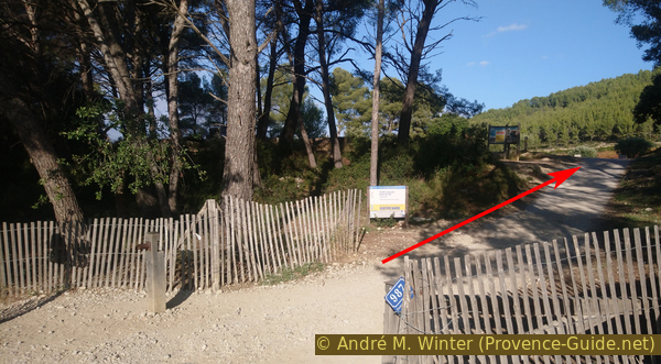
Coming from the port of La Madrague, walk up the narrow Avenue de l'Abbé Dol in a southerly direction, an arrow points towards Sentier des Vignes. Go past the roundabout and after a bus stop and a narrowing of the lane, a path starts on the left that then runs along a vineyard and under the old house La Bastide de la Nartette. In about ten minutes we are at the starting point.
With the Navette des Quartiers, get off at the Hauts de la Madrague stop and follow the above description as from La Madrague.
Access by car
Saint-Cyr is located between Marseille and Toulon, more precisely between La Ciotat and Bandol. There is a freeway exit north of town. Then follow the signs to the centre, then to Les Lecques and finally to La Madrague. Pass La Madrague Port, then straight ahead at the following roundabout to exit the city. When you reach a kind of saddle, on the right side we see the prohibition signs on the access road to the Don Bosco school. On the left is the start of the hike and you can park on the left before and after.
Useful parking spaces
Near the start of the walk as described above along the Chemin de Nartette.
Please note that there are different paid parking zones in the city between March and October inclusive.
No reproduction is permitted without the written consent of the author. (id5843)
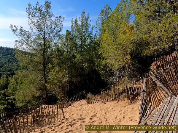
The path in the upper section of the dune
Hints
The tour is described clockwise as we end up descending over the sand dune to the south. Going the other way is a much more strenuous endeavor.
As on the beach, you have to empty the sand from your shoes when you leave the dune area.
The round is short, you may add a much longer tour from the same starting point: Pointe du Défens and Port d'Alon.
The whole region is a zone with a high risk of forest fires. In summer, but also in other seasons when it is very dry or by strong winds, access to the forest areas can be regulated. As a result, the roads may be closed to traffic and/or the trails prohibited to hikers. Current information: Map of access to the forests of the Var (also english). The map shows the colours green, yellow, orange and red which correspond to levels of danger. The affected area is: Monts Toulonnais (1).
The sections
- Nartette - la Gâche
- La Gâche - sand dune - Nartette
Section 1: Nartette - la Gâche
➙ 3 km ... 45 min ➚ 170 m ➘ 25 m ↝ easy
90% forest roads, without marks
5% cross country, without marks
5% easy trails, without marks
The clues
- La Nartette, 70 m
- La Pinède, 100 m
- La Gâche, 215 m
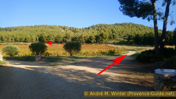
We circum-hike the vineyards of the Bastide de la Nartette to the north and walk along forest roads and clockwise through the slopes of La Gâche hill. At the end it gets a bit steeper.
We go up to the right of the vineyard and turn left behind them.
This field and the house in the middle are special: they belong to the Conservatoire du Littoral and are managed as they were in the early 20th century.
No reproduction is permitted without the written consent of the author. (id5824)
Access to Nartette vineyard
La Bastide de la Nartette dates from the 16th century and is the oldest building in the municipality after the Château de Baumelles. This farm was built on the slope near a small spring that also gives it its name. The Indo-European base NRT denotes a place where water is found.
Historically, there weren't that many vines in Provence. Mainly grain was grown, also here at La Nartette. The vine and the olive trees, along with the vegetables, were only grown around the dwellings. There is still a threshing floor from the time when grain was grown.
No reproduction is permitted without the written consent of the author. (id5825)
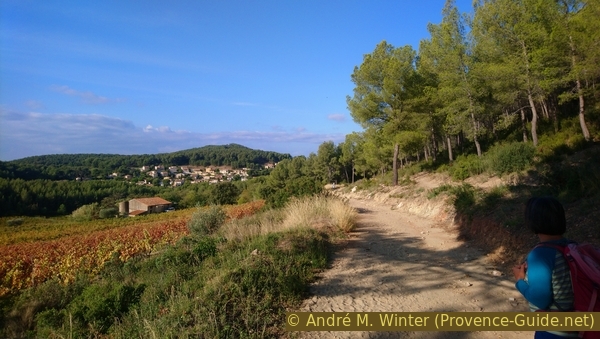
Nartette vineyard and La Gâche
The large field is sloping and has been tiered with dry stone terraces (restanques) to keep rainwater and soil in place. The vines are traditionally cultivated and result in the Cuvée Conservatoire du Littoral.
North of the vineyard we walk on sand for the first time, it comes from the dune over which we will go down at the end of the tour.
No reproduction is permitted without the written consent of the author. (id5826)
The sandy path above the Nartette vineyard
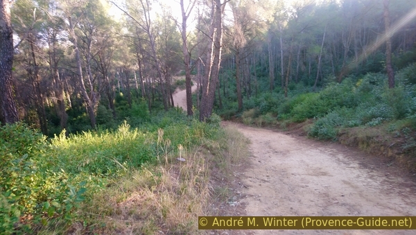
The path then leads on a wide forest path into a pine forest. We always follow the main path that goes around the hill. We can see the villas through the trees on the left. After a saddle there is a short descent, but in general the route is rather uphill.
A little over five minutes after leaving the vineyard and before a steeper climb, there is an opportunity to descend to the left to a first sandy area.
In the period before the villas by the sea were built, the north wind Mistral lifted sand and brought it here and to the top of La Gâche.
No reproduction is permitted without the written consent of the author. (id5827)
Forest road west of La Gâche
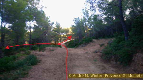
We return to the wide forest road and continue in a north-easterly direction, always taking the right forest track at the junctions. We come to an open area with a first extinguishing water tank marked SCM2. Here we turn right, the path climbs in two switchbacks to another tank marked SMC1. You can already see some rocks on the top left.
No reproduction is permitted without the written consent of the author. (id5828)
Forest road north of La Gâche
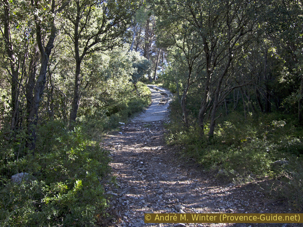
At the second extinguishing water tank we turn left. The path becomes narrower and steeper. Above it is partially concreted. This way we get to a small rocky cirque, where we enter.
No reproduction is permitted without the written consent of the author. (id5829)
Forest road in the La Gâche cirque
The ridge consists of jagged rock pinnacles in the northern and eastern parts. Here is also the natural summit of La Gâche.
No reproduction is permitted without the written consent of the author. (id5830)
La Gâche cirque
Arriving in the flat part of the cirque, we can climb off the path to the northern part of the ridge to find an ideal view near an antenna.
No reproduction is permitted without the written consent of the author. (id5831)
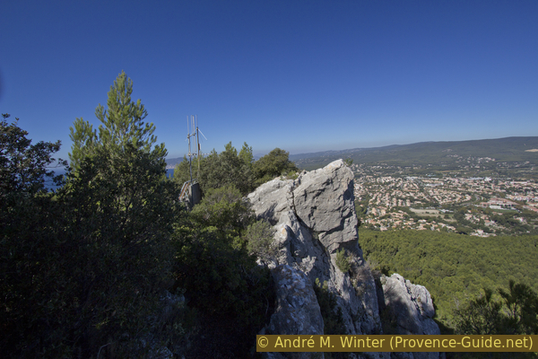
Antenna on La Gâche north summit
To the west and left of the antenna you can see the Plage des Lecques beach and Saint-Cyr.
No reproduction is permitted without the written consent of the author. (id5832)
View on La Ciotat gulf
Famous villages lie to the north.
No reproduction is permitted without the written consent of the author. (id5834)
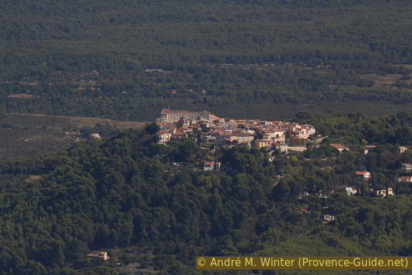
Le Castellet
On the other side of the antenna, the view extends to the Château des Baumelles, among others.
No reproduction is permitted without the written consent of the author. (id5835)
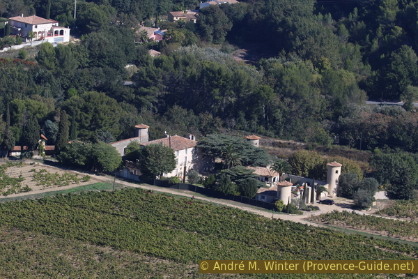
Château des Baumelles
We follow the cliff edge to the right for about fifty meters before descending back into the cirque to head south to a more easily accessible vantage point.
No reproduction is permitted without the written consent of the author. (id5836)
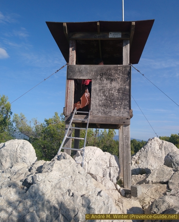
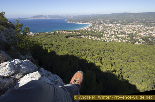
La Gâche lookout
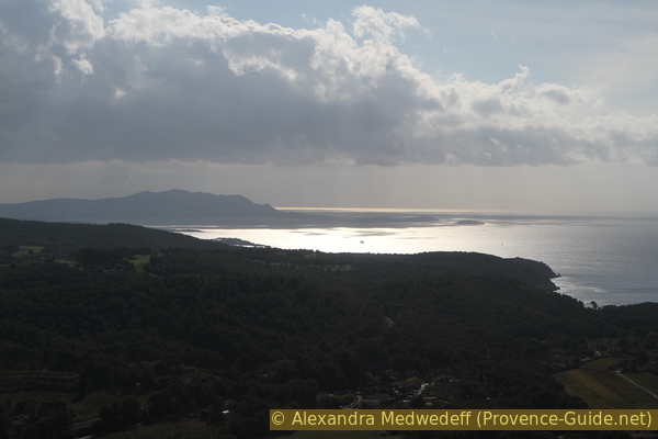
Coming out of the forest we already have a good view towards Bandol and Port d'Alon. But if you climb into the small watchtower, you also have an ideal view of the large peninsula of Saint Cyr. This has no official name, the Cap du Défens is the most prominent point in the south.
No reproduction is permitted without the written consent of the author. (id5837)
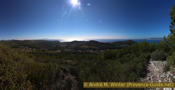
Saint-Cyr peninsula
In the southeast lies Cap Sicié with its large wooded elevation.
No reproduction is permitted without the written consent of the author. (id5838)
Cap Sicié on the left
To the west lies La Ciotat with the striking Bec de l'Aigle and beyond the Cap Canaille.
No reproduction is permitted without the written consent of the author. (id5839)
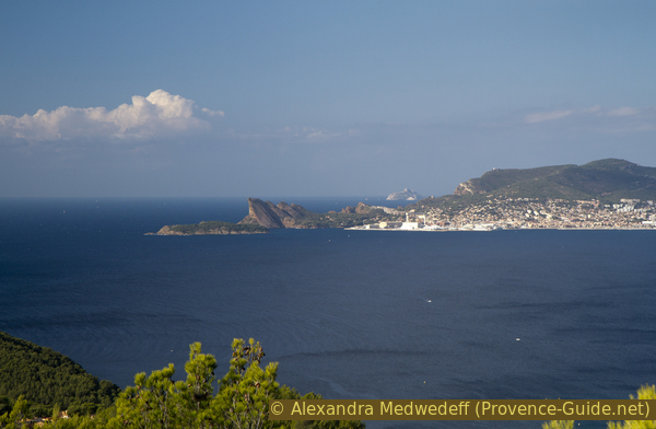
La Ciotat on the right
Section 2: La Gâche - Dune de Sable - Nartette
➙ 0,9 km ... 25 min ➚ 10 m ➘ 155 m ↝ easy
75% easy trails, without marks
25% forest roads, without marks
The clues
- La Gâche, 215 m
- Sand dune
- La Nartette, 70 m
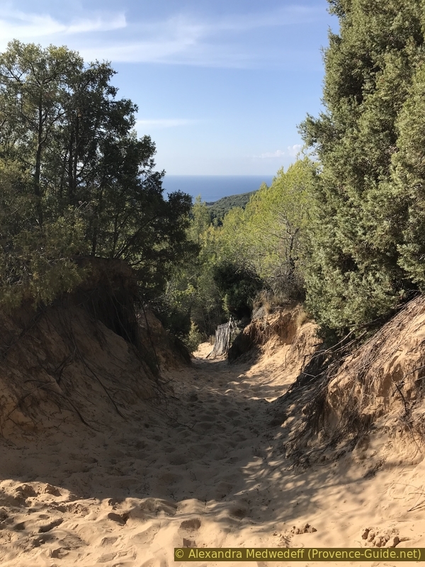
In this section we descend the Dune de la Gâche. It's a curiosity of first order, but little known. Below we explain the formation and threats of the dune.
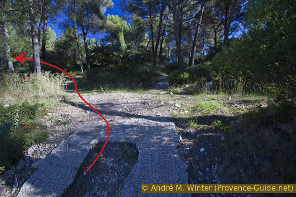
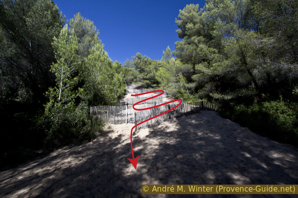
From the viewpoint, continue along a path between rocks and bushes, keeping the general direction to the west. Sometimes we notice sand on the way. After a few minutes we go down in a saddle and then without changing direction uphill for a short time. Now it's time to turn left and look for a sign. The dune begins just below.
No reproduction is permitted without the written consent of the author. (id5840)
La Gâche dune
However, it is not a dune in the classic sense. The strong north wind Mistral lifted the sand from the nearby Plage des Lecques beach and deposited it north of La Gâche. We saw the remains of these sand deposits in section 1. However, the wind is so strong that it also blew the sand over the ridge and the small pass we just came over. This lighter sand therefore covers part of the southern slope. The strength of the Mistral is undoubtedly enhanced by a siphon effect in the Géménos area.
No reproduction is permitted without the written consent of the author. (id5841)
Saint-Cyr dune
Today the supply of sand from the north is prevented by the houses on the beach. That is why the dune and the very specific plants that live here are threatened. Each grain of sand that slides down is no longer replaced at the top.
For this reason it is not allowed to simply run down. You always have to dodge sideways or zigzag between the barriers, which also help to fix the sand. The upper part is the steepest, here you have to stay on the side and make a detour to the left. Further down you can walk directly in the sand as long as you follow the given path. Protected zones have been created in the bypassed areas to save plants such as Crucianella maritima, beach grass and lucerne.
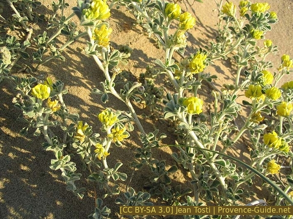
Medicago marina
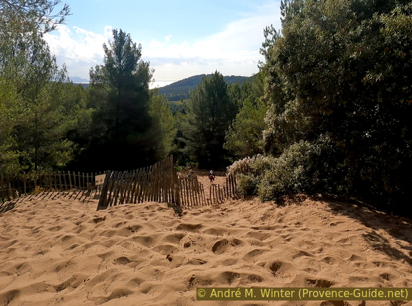
Further down, the sand flattens out and you descend into a pine forest.
Finally we come back to the well-known vineyard. In a few minutes we are back at the starting point.
No reproduction is permitted without the written consent of the author. (id5842)
View back on the dune
Sources and additional information
It is better to use a good topographical hiking map: this tour is on the IGN map "Aubagne, La Ciotat, Massif de la Sainte Baume", scale 1:25000, 3245ET.
If you don't want to bother with a paper map, you can also use mapping apps on your cell phone. On the one hand, it is the Cartes IGN app from the official map service. However, it requires access to the data network and this is sometimes difficult in canyons or remote locations.
Alternatively, you can use apps that store data directly on the device. They're generally not free, but they don't cost much. We mainly use OSMAnd, here it is possible to add contour lines, relief shading, markings and others. To store this data on your phone you need a lot of space.
Of course, one needs access to satellites for the GPS signal with any app. In some canyons this is not the case. Therefore, do not rely on the position shown, but read the map on your phone as you would read it on paper. Most apps are available for Android and iPhone. The applications usually allow us to record the route travelled and also view the GPS files offered for each of our hikes.
This page has been seen 3166 times since 20 March 2024.