The wild coast of Cap Sicié
Steep and difficult coast next to the beaches of Six-Fours-les-Plages
hike
difficult
5 h 45 min
near
yes
no
mountain
Introduction
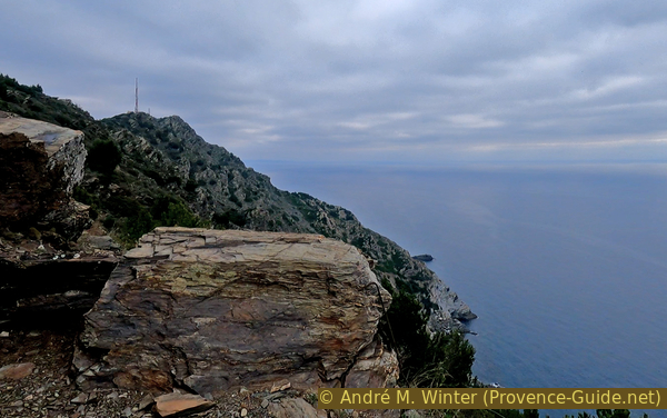
The footpath along the French Mediterranean coast is known for its scenic stretches along the water. But this area proves that things aren't always so lovely. It's really wild here and the terrain is alpine. The slopes are rocky and steep. We reach over 330 m above sea level. First of all: there is no access to cosy beaches and bays on this hike. You can only get to the water if you extend the hike north towards the bay of Fabrégas at the end. With the heights reached, the view is of course grandiose: there are several worthwhile panorama points. A chapel and ruins of coastal surveillance are along the way.
Walking the coastal path and getting back to the starting point via a different route is not always easy. Here, however, it works out to a large extent because some paths run parallel, although they are very different. Those closer to the water are much more difficult, more exposed and more at risk of falling rocks. Because of these sections, this tour is marked as difficult, but all tricky areas can be bypassed on easier routes. Be sure to follow the hints below and the comments in the individual sections!
The facts
12,8 km total distance
5 h 45 min walk time
920 m total elevation
orientation easy, but few signposts
mark 90% of the total distance
35% easy trails
10% moderate trails
10% hard-surfaced quiet side streets
10% forest roads
10% dirt roads
10% difficult trails
5% stairs
5% Trails with scramble passages
5% exposed trails
<5% cross country
dangers exposed path, blocked but passable section
children only with sufficiently experienced adults
useful picnic stuff
required hiking boots, hiking equipment and water
GPS coordinates (WGS84) of start and end point 43.066282,5.820271
downloads ![]()
![]()
No reproduction is permitted without the written consent of the author. (id3255)
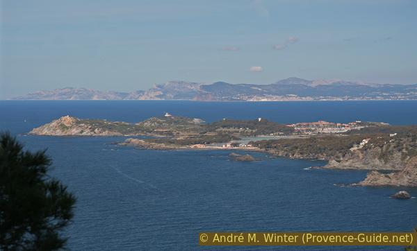
View of the Embiez Islands
With the heights reached, we will have a view of a large part of the Var coast and even Bouches-du-Rhone.
Public transport
The nearest train stations are Toulon TGV station and the La Seyne/Six Fours and Ollioules/Sanary regional train TER PACA (only french) stations. From these stations and in the direction of Cap Sicié, which stands out on the sea between Six-Fours-les-Plages and Seyne-sur-Mer, there is the Réseau Mistral (only french) transport network that covers the greater Toulon area. These bus lines allow you to get close to the starting point in La Lèque at the port of Le Brusc.
ligne = bus line
vers = to
gravures = engravings
abri sous roche = cave
Two bus lines head for the area:
Line 72 comes from the beaches, from the centre of Six-Fours or even Toulon with about 4 connections per day. It is best to get off at Roches Blanches, then continue walking for about 1 km along the Chemin de Mouries (signs point to Cap Sicié and Notre Dame de Mai), then turn right (same signs). At the next crossroads we change to the Chemin de la Lèque (no longer follow the previous destinations on the signs). The tour starts at the beginning of the Chemin des Cargadoux. Altogether additional 1,6 km and 40 min one way.
Line 87 makes it possible to come from Les Sablettes and from the centre of Six-Fours, here with around 20 connections per day. Get off at the harbor master's office (Capitainerie) in Le Brusc and take the Montée du Gros Pin (sign Espace naturel du Mont Salva), then the Chemin de la Gardiole. After about 700 meters, the road turns right and soon left again. We are now on the Chemin de la Lèque. After another left-right bend, we have to keep to the right and take the Route de la Lèque until we come across the Chemin des Cargadoux, where the tour begins. Altogether additional 2,4 km and 1 hour one way.
If you don't want to do a circular tour and avoid the rather demanding descent before reaching Cap Sicié, you can continue north along the east coast of the cape and take line 81 from Fabrégas to the town centre of La Seyne. From the ruined coast watchtower at the top of Cap Sicié to Anse de Fabrégas it is approximately 4 km and 1 hour. Description of the path: first go down the bends of the gravel road through the Terres Gastes until you come to the loop in front of the tunnel portal of the entrance to the sewage treatment plant. Go down this curved road (sign AmphitriA, traffic ban with barrier) and take a little visible path on the right just before the tunnel entrance. The path first leads strictly eastwards downwards, parallel to the road further up. Further down we come across a gravel road again. Turn left here and after 20 metres turn right again downhill. This is how we get on the official and marked coastal footpath, on which we turn left again north to the villas above the Bay of Fabrégas. Unfortunately, you have to walk through a hairpin bend through the private complex of houses on the Chemin de Baou Rouge, but this is the only way to get to the small beach. From here, perhaps after a break, up the Route de Fabrégas to the large roundabout, terminus of line 81 to La Seyne. A description of trails on this side with photos and a map can be found at Trails on the east side of Cap Sicié (only french).
No reproduction is permitted without the written consent of the author. (id3269)
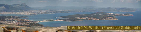
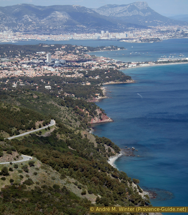
Bay of Toulon and Saint-Mandrier
Here is a view to the east, as you have it later along the hike.
Access by car
The centre of Six-Fours is not clearly discernible. A major road crosses the town from the beaches of Six-Fours in the west to the town of La Seyne in the east. Several roundabouts are arranged here, at one the main road makes a slight bend, the cooperative and the pharmacy (Pharmacie du Pont du Brusc) stand out. Turn south here (signs Le Brusc, Chapelle ND de Mai, Cimetières) and continue on Avenue Laennec for a while. When the road bends to the right, leave it and follow the signs (Chapelle ND de Mai, Massif du Cap Sicié, Déchetterie). Now stay on the Chemin de Mouries, which turns right. Shortly after, we continue straight on, although the signs (Chapelle ND de Mai, Massif du Cap Sicié) point to the left. We are now on the narrower Route de la Lèque, which leads us to a small crossroads with a yellow post box. The dead end Chemin des Cargadoux is our path. From now on it makes sense to look for a parking space in the bushes on the left and right of the road, because the road will be unpaved after 200 m and a barrier follows soon after.
Useful parking spaces
Access to the starting point is possible by car, but there is little parking. The only official car park is at the end of the Route du Brusc (Corniche des Îles, in the far south-west of the peninsula). From here you have to walk back to the port and take the routes described under public transport (line 87) to the starting point of the tour. In the low season, you can try to drive closer to the starting point, there are a few parking possibilities. The Chemin des Cargadoux is the access to the hike. This road turns into a forest track with barriers at the end. Here you can park on the sides.
Hints
This stretch of coast is very wild, steep and fully south facing. With full sun it can get very hot here in all seasons, in midsummer midday should be avoided. As the trails run very high above the sea, it is also possible to hike in strong sea winds. You are less protected from Mistral, as you are also on the high ridge line for a long time.
The section between Montjoie and the radio mast at Notre-Dame de Mai Chapel is exposed and partly built into the rock, but poses no problem for hikers. The situation is quite different between the ruined coast watchtower and the installations at the cape below. There is a risk of falling rocks, the path is steep and slippery. You have to be careful not to throw stones on hikers further down.
The whole region is a zone with a high risk of forest fires. In summer, but also in other seasons when it is very dry or by strong winds, access to the forest areas can be regulated. As a result, the roads may be closed to traffic and/or the trails prohibited to hikers. Current information: Map of access to the forests of the Var (also english). The map shows the colours green, yellow, orange and red which correspond to levels of danger. The affected area is: Mont Toulonnais (1).
The sections
- La Lèque to Montjoie: easy dirt road and easy path with detours to caves and rock carvings
- Montjoie to Notre-Dame du Mai chapel via the lower coastal path and the Cap Vieux coastal defences on a mountain path
- Chapel of Notre-Dame du Mai to the Coast Guard Tower on the crest
- Coastal watchtower, Cap Sicié front and back
- Coastal watchtower to Montjoie: Gravel road and paths along the crest
- Montjoie to la Lèque: back on the way there
No catering facilities along the route.
No reproduction is permitted without the written consent of the author. (id3259)
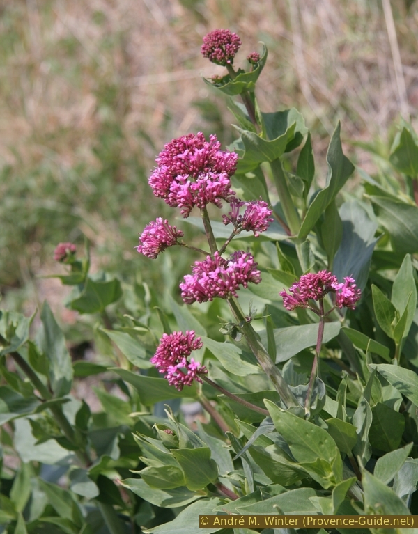
The red spurflower blooms here in spring
Section 1: La Lèque - Montjoie
➙ 2,8 km ... 1 h 10 min ➚ 160 m ➘ 105 m ↝ difficult
25% hard-surfaced quiet side streets, few marks
<5% forest roads, with marks
5% easy trails, without marks
25% forest roads, with marks
15% Trails with scramble passages, without marks
30% easy trails, with marks
The clues
- On the Chemin des Cargadoux to the barrier
- Detour down to a natural shelter
- Follow the forest road and then the path marked in yellow
- Detour upwards for historical engravings
- Climb via the Point de l'Éperon and continue to the junction at Montjoie, 150 m
Sketch map above under public transport.
No reproduction is permitted without the written consent of the author. (id5889)
Down to the rock shelter
At the end of the asphalt band, there is a bumpy gravel road that is closed to traffic after a few meters. At the barrier, there are signs that explain the paths at Cap Sicie more badly than right.
A few meters after the first barrier, an unmarked path branches off to the right to Plage de la Fosse beach. There is a small detour here: we first take the flatter path on the left and then the somewhat steeper path on the right downhill.
In a few minutes you come to small semi-caves that served as a shelter. The rock Dolmen de la Lèque is wrongly called.
Then back up to the forest road and turn right here.
No reproduction is permitted without the written consent of the author. (id5890)
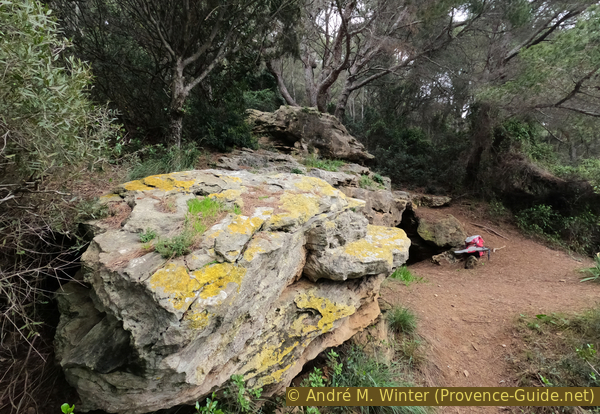
Rocks with small caves
The dirt road progressively narrows and turns left at a right angle into the Vallon de la Fosse. When we come out of the valley again, we cross a barely noticeable ridge. Here we must discern the path that pulls up left. It leads to important historical rock carvings from the 18th century. The trail is clear, but not marked as the IGN map suggests. The location of the rock engravings is not specifically marked on site, ideally you should follow the guide below and the GPS track.
No reproduction is permitted without the written consent of the author. (id5891)
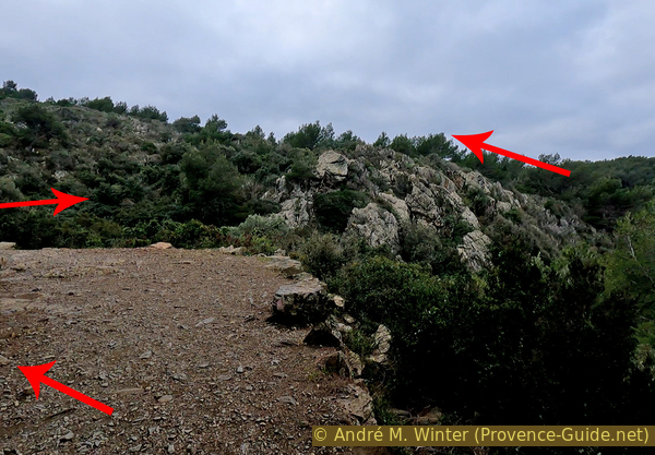
Right angle of the path and valley to be crossed
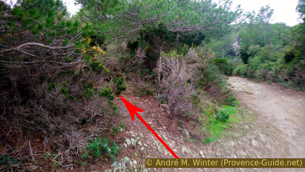
In order to reach the engravings, the linear distance is 180 meters and an altitude difference of 35 meters has to be overcome. There are few clues. After five minutes, the most important is a rock bar that is crossed. Under some stunted trees we climb a few more meters to find a flat area to the right of the path. These are overgrown with low bushes and there is also some rubbish lying around.
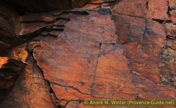
In front, we see that we are on a cliff of rocks burned by the sun. We have to descend about four meters to the bottom of the rocks. Here are the most remarkable engravings on Cap Sicié.
No reproduction is permitted without the written consent of the author. (id5892)
Up to the rock carvings
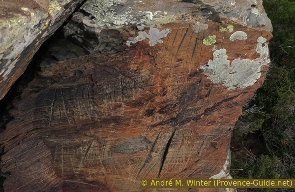
These are mainly merchant ships from the mid-18th century. One engraving represents a church. They are very similar to the engravings seen on the walls of old penal colonies or prisons such as the Tarascon Castle.
These naval graffiti mostly feature lateen sails, suggesting that these ships are of type shebecks that combined sails and oars for near-shore voyages. The details of the rigging are very faithful to the original. Other engravings depict tartans and schooners.
No reproduction is permitted without the written consent of the author. (id5893)
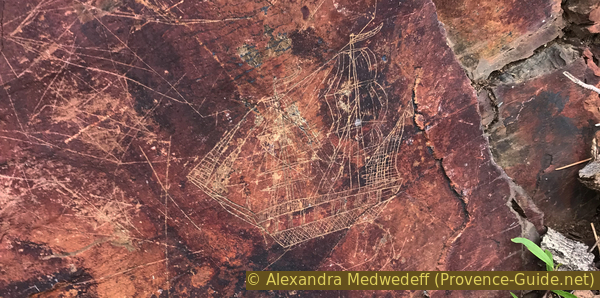
Carving of a large sailing ship
In addition to ships, there are also depictions of people in fighting postures and on horseback. Scattered on these rocks are also animals and simple signs.
This is not the only engraving site on Cap Sicié, but it is the most complete and accessible one. These engravings were only rediscovered in the early 1990s and there is still no detailed scientific studies of them. What is certain, however, is that several epochs overlap, which is made clear by the different naves and the different stages of erosion of the carvings.
The rare excavations at the foot of the rocks have given no clue as to the origin of the engravings. They are probably too elaborate to be the work of local fishermen. The proximity of Toulon, with its military port and penal colony, suggests that the engravings originated maybe from there.
No reproduction is permitted without the written consent of the author. (id5894)
Carving of a church
It is possible to go further up the ridge to find parallel lines on some rock faces 50 meters further in a similar position. They seem to have served as natural grindstones.
No reproduction is permitted without the written consent of the author. (id5895)
Natural sharpening stone
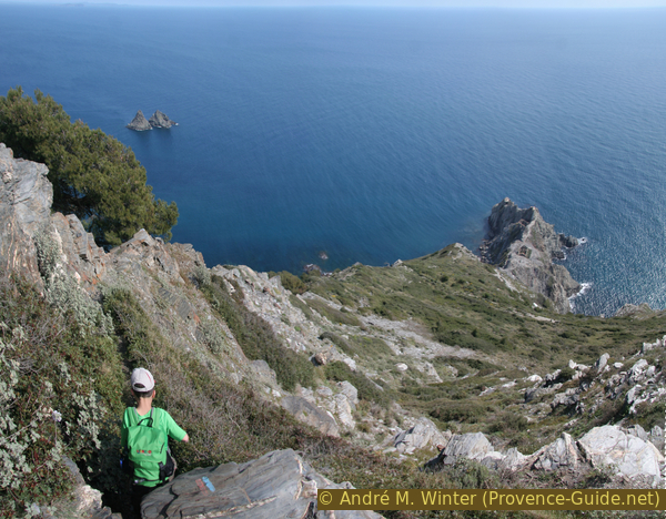
However, we go back down to the main path and turn left here to walk on the ridge above the Pointe de l'Éperon and Montjoie. Barely 30 meters further, at an unmarked junction, follow the markings, keep to the right and proceed onto the ridge line. Here you have a good view back to the Embiez Islands, to La Ciotat with its Bec de l'Aigle and if the weather is good to the Calanques of Marseille with Calanque de Morgiou.
Above the Pointe de l'Éperon, the path turns left and descends a little. From there we can already see the cliffs of Cap Sicié, where we will spend the rest of the tour on paths of all levels of difficulty. After another climb, there is another bifurcation: on the left is the Roumagnan ridge (this is our way back), on the right we go (at first) less steeply into the slope.
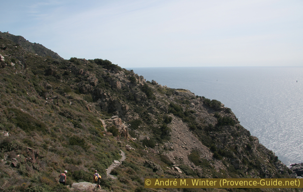
No reproduction is permitted without the written consent of the author. (id3256)
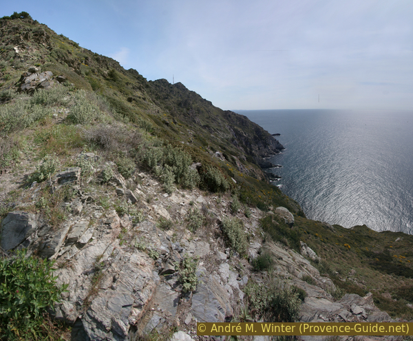
South slope of Cap Sicié after Montjoie
We take the path in this exposed southern slope.
Section 2: Montjoie - Batterie du Cap Vieux - N.D. du Mai
➙ 2,6 km ... 1 h ➚ 300 m ➘ 150 m ↝ average
60% moderate trails, old marks
10% cross country, without marks
15% exposed trails, old marks
5% easy trails, few marks
10% dirt roads, few marks
The clues
- Turn right at the junction at Montjoie
- Crossing the slope without much ups and downs
- There and back to the coastal defences at Cap-Vieux
- Steep uphill through the rock to the transmitter and the chapel
Exposed path with deep views. There is no trail to the ruins of the coastal defence system at Cap-Vieux, but it is easy. Possibility of bypassing the section above behind the ridge, turn left at Montjoie, this corresponds to Section 5 in reverse.
pylône = transmission mast
ND du Mai = Church Notre-Dame-du-Mai
batterie = old coastal defences
pointe = cape
The path fork is in front of a flatter area. Our later way back can be seen on the left. A sign informs that the path straight ahead is no longer maintained, but it is not forbidden to walk here. It's like an invitation to explore this wild stretch of coast. So we go straight ahead, past the yellow X mark.
The path climbs a little more on the slope, then descends to stay at around 150 metres above sea level. The sea continues to accompany us, without going down. Below the path, the slope drops even more steeply to the water, opening up magnificent deep views of the surf.
No reproduction is permitted without the written consent of the author. (id3258)
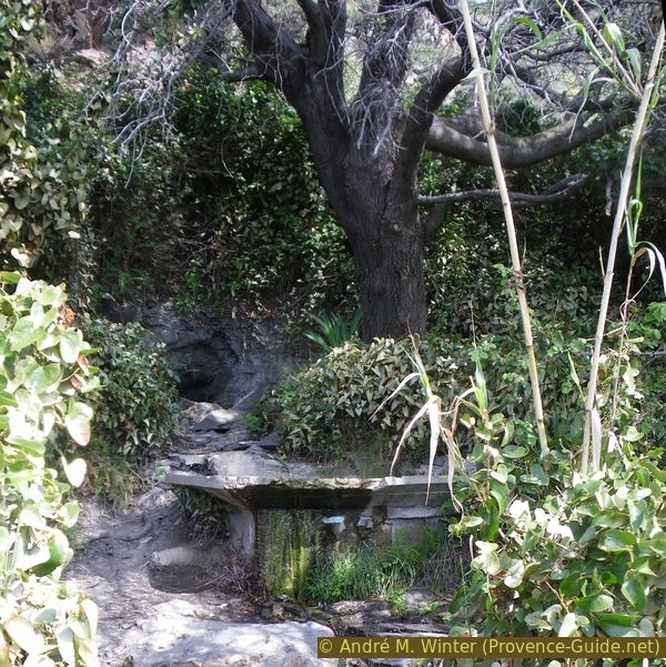
Source at Coudouré at Cap Sicié
Above an inconspicuous cape (Pierre de l'Autel), the path bends to the left. Here the landscape becomes more barren, more rock peeks out through the sparse vegetation. This ambience is not desolate, because you can also see interesting geological outcrops and bizarre forms of erosion. If you come here in spring, everything is adorned with a sea of flowers!
In this wild and sloping landscape, about 10 minutes after the cape, the Pierre de l'Autel follows on the left just above the green reed grass. There is actually a small spring here that supplies water when there is not a long dry period. The source is contained in a basin. The water looks good, but we advise against drinking it.
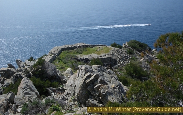
20 minutes after the source, we reach the ridge above the Pointe du Cap-Vieux. The remains of a military coastal defence system can be seen on a flat rocky outcrop, as can be found several ones along the Mediterranean coast. They mainly date from the 18th century. Only the wide sea-side wall, behind which the cannons were set up, is visible.
No reproduction is permitted without the written consent of the author. (id3260)
Crest over the Cape Pointe du Cap Vieux
Here you can descend to the old coastal defences. That even makes sense, because the leveled area is grassy and you can take a break in the slipstream at the wall. We leave the former marked path where it rises steeply towards the TV antenna. There is no real way to descend, you have to look for the easiest way through. The rocks here are big and not wobbly. Don't go too far to the left (east), because here it gets steeper and more crumbly. You aim roughly at the clearly visible platform. Important here: remember the way through for the way back, because there are not so clear clues in the other direction.
No reproduction is permitted without the written consent of the author. (id3262)
Former coastal defenses at Cap Vieux
Along the path with old marks and on the way down to the military platform, you keep seeing a curious semicircular construction with no visible road access under the rock wall by the water.
This isn't James Bond's secret flop-house, the big holes aren't launch pads for ICBMs. It is the treatment plant called Amphitria of the greater Toulon area. It is well hidden, but visible to us hikers.
No reproduction is permitted without the written consent of the author. (id3261)
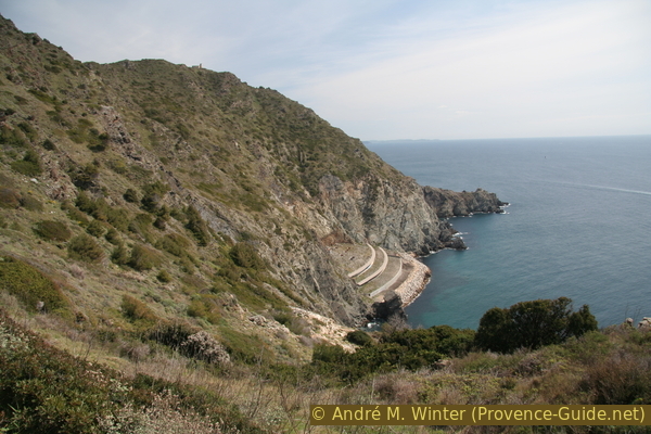
Wastewater treatment plant Amphitria and the Cap Sicié
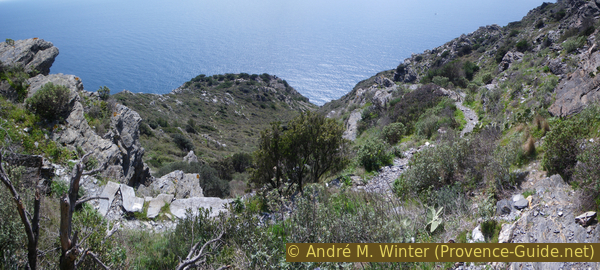
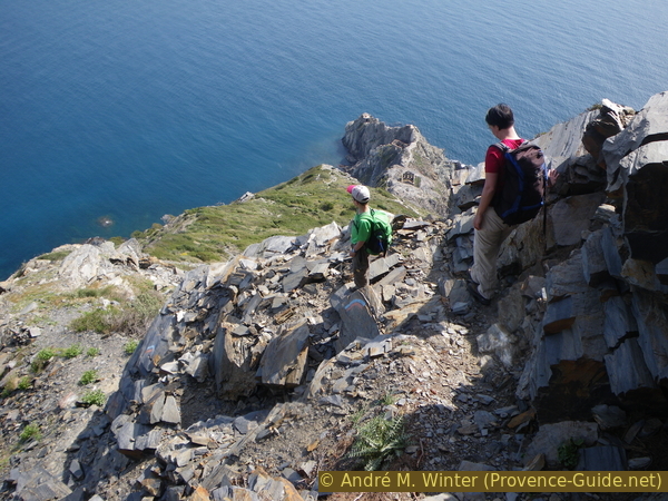
After the break at Cap-Vieux you have to clench your teeth. It now goes up 200 metres vertically along the fall line. This takes place in three stages: the first is the ascent to the path back over the rocks and under the pine trees.
The second is the rocky climb to the transmitter, it's an exposed trail and you have to be careful where you step.
The third section is an easy almost flat path on the plateau.
No reproduction is permitted without the written consent of the author. (id3264)
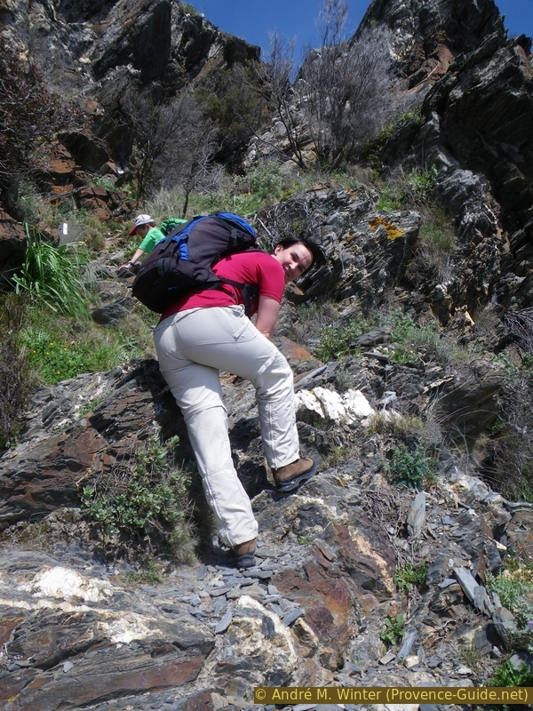
Hiker on the demanding path south of the transmitter
When it's hot, take it slow.
The eye of the interested geologist will remain alert despite the sweaty ascent.
No reproduction is permitted without the written consent of the author. (id3263)
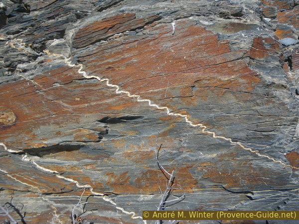
Phyllade (phyllite) with quartzite inclusions
Only in retrospect does it become clear how steep the ascent actually is and where the path leads through!
No reproduction is permitted without the written consent of the author. (id3265)
Above the Cap Vieux
On the way to the transmitter, you can see back to the west coast with the islands (photo).
At the top of the plateau, we leave the path on the crest (our way back) on the left, continue to climb behind the large antenna and reach the Notre-Dame du Mai chapel from behind.
No reproduction is permitted without the written consent of the author. (id3266)
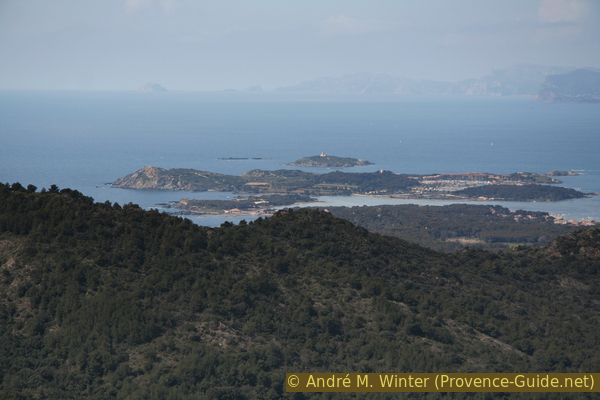
Îles des Embiez islands
The Chapel de Notre-Dame du Mai, also known as La Bonne Mère or Notre-Dame-de-Garde, is a formerly well-known local pilgrimage site. The small church was built in 1625 after a lightning strike destroyed a watchtower without harming the guards.
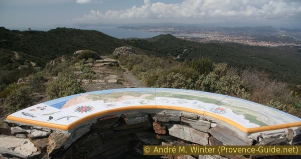
In front of the chapel's east-facing facade is a small concrete platform with a 360° panoramic panel.
No reproduction is permitted without the written consent of the author. (id3268)
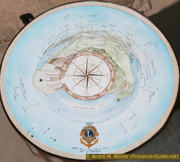
Orientation panel at the chapel
Section 3: Notre-Dame du Mai - Sémaphore
➙ 0,8 km ... 15 min ➚ 30 m ➘ 50 m ↝ easy
100% easy trails, few marks
The clues
- Go east from the chapel without crossing the road on the left
- Proceed to the destroyed Coast Guard Tower
The picture shows the stage destination, seen from the chapel.
No reproduction is permitted without the written consent of the author. (id3267)
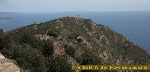
Eastern highest point of Cap Sicié with ruins
de = from
pylône = television antenna
sémaphore = coastal watchtower
station d'épuration = sewage treatment
ND du Mai = church Notre-Dame-du-Mai
Easy trail along the ridge, do not go out onto the gravel track that runs parallel.
Between the road and the ruins of the coast watchtower there is another panorama board at point 330 metres on the IGN map.
No reproduction is permitted without the written consent of the author. (id3270)
Orientation board at point 330 metres
The coast watchtower at Cap Sicié is badly damaged, as is the building further down on the left.
From here you can see the eastern coast of the peninsula, but also on Saint-Mandrier and the Coudon mountain in the background.
No reproduction is permitted without the written consent of the author. (id3271)
East coast of Cap Sicié and Les Sablettes isthmus
Section 4: Sémaphore - Cap Sicié - Sémaphore
➙ 1,9 km ... 1 h 40 min ➚ 350 m ➘ 320 m ↝ average
30% difficult trails, old marks
40% stairs, without marks
30% difficult trails, old marks
The clues
- Descend from the coast watchtower to the ruins at the bottom of the cape
- Again up the same path and on the gravel road back to the chapel
Now we have reached the wildest but also most interesting section. How often does a warning need to be given here: this section crosses dangerous and unsecured terrain. There is a red and blue marked path, with experience and awareness the descent to the ruins at the bottom of Cap Sicié is viable.
The slope is slippery and loose rock may have slipped further before your way through. You have to check again and again whether you can go on. Never jump over a difficult section! Firstly you don't know how well the landing point will hold, secondly and this is almost more important: you must be able to turn back at any time because there is no alternative to this path. If an impassable point follows later, you and other hikers must be able to cross all the previous tricky points again on the return route.
No reproduction is permitted without the written consent of the author. (id3272)
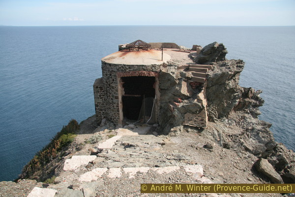
Ruin at former coast guard tower
On the right it passes the trail that is still easy here.
vers = to
pointe = cape
portail = gate
poste photoélectr. = generator
sémaphore = coastal watchtower
ND du Mai = church Notre-Dame-du-Mai
The small map shows the steep descent to the front Cap Sicié with a red dashed path. Until about 2018 it was possible, albeit officially forbidden, to proceed from the ruins to the right and right to Cape Pointe des Jonquiers. Since then, however, erosion has progressed so far that the path has been completely eroded. The loose rock on the east side is constantly in motion, walking through it is strongly discouraged!
If you want to avoid this not entirely safe loop, there are two options from the watchtower: go back and switch to section 5 or end the tour in Fabrégas, see public transport above.
No reproduction is permitted without the written consent of the author. (id3273)
Deep view of the Cap Sicié
Marks are blue-red here.
Let's tackle this difficult section: It's 300 metres downhill and that in a linear distance of only 500 metres! Pass the coast guard Tower on the left, below it on the right in front of the roofless ruins. Some parallel paths lead to the steep ridge that forms Cap Sicié. You pass the last walls. The path becomes noticeably steeper. It meanders through amounts of splintered slate rock.
There is a fork here, the two paths come together again further down. However, the one on the left, closer to the ridge and marked blue-red, may be in a better condition. The rock cracks under the action of the wind and the salt water. Our path leads through the stony labyrinth in tiny hairpin bends. You almost always stay to the right but close to the steep ridge line.
No reproduction is permitted without the written consent of the author. (id3274)
In the crumbly section down to Cap Sicié
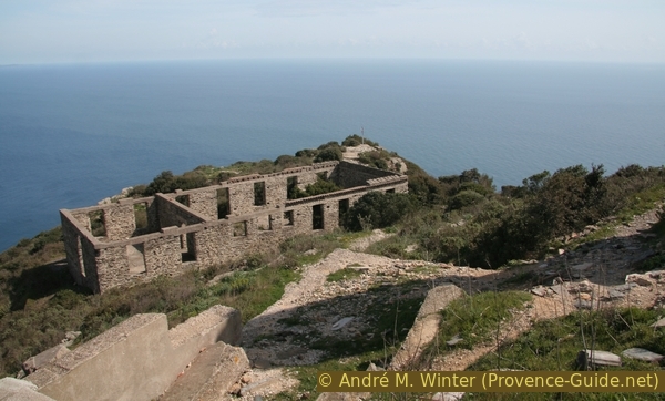
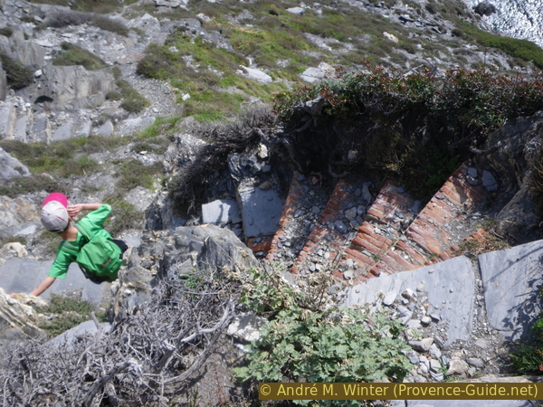
When it gets a little less steep, the rest of a formerly paved path begins. It leads further and further down to the upper ruins on the cape (two houses of which only the walls are still standing, at about 50 metres above sea level).
Here the path gets much better as it is no longer exposed to the rockfall of the slope. After an old and unsecured loading ramp, you pass a rocky outcrop with a beacon that is still active. At 20 metres above sea level we are standing in front of a tower with a large hole underneath: this is an old freight elevator. Attention, nothing is secured here, be sure to watch out for children!
No reproduction is permitted without the written consent of the author. (id3276)
Old stair down to Cap Sicié
These facilities are left from an old military electric directional searchlight used to support former artillery positions. A power generator and fuel cisterns were housed on site in the buildings above. The course of the lines is still visible. At the base of the lower freight elevator was the searchlight position and the combat post. You can no longer get there on foot, not even via the steep ramp further up, you would have to dock with a boat.
There is another very similar facility further east on the peninsula of Giens near Hyères near Escampo-Barriou. The derelict and ruined installations look desolate, but it's still fascinating what inaccessible stretches of coast they were built on back then.
No reproduction is permitted without the written consent of the author. (id3277)
Old freight elevator at Cap Sicié
It is clear that one will hardly be able to go further from the front of the Cape. So we have to go back up to the second ruined house and loop the path in front of it to the right. You can see immediately that the slope consists of much finer grey rock. This is not a good sign for slope erosion and trail condition. No one has rehabilitated this fundamentally interesting path, perhaps because it doesn't lead to a beach with a bar? But investments have been made in barriers designed to discourage hikers. The door is massive and defensive, but you can still get past it. The picture is from 2010, since then a fence has been installed left and right, but it has been broken through. A hike description approaching this passage from the other side 2021 with photos and a map can be found at Trails on the east side of Cap Sicié (only french).
But as described above, we do not continue here and thus return to the ruins at the cape and start the arduous climb back towards the chapel.
No reproduction is permitted without the written consent of the author. (id3278)

No way between Cap Sicié and Pointe des Jonquiers
Again and again you can see the striking rocky islands Les Deux Frères (Two Brothers). Like the coast we are on, these rocks are rugged and it would be difficult to dock a boat.
No reproduction is permitted without the written consent of the author. (id3281)
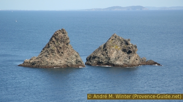
Rochers des Deux Freres
As we have walked enough on narrow paths, we take the road back to the chapel. This is the usual approach from La Seyne to the Notre-Dame-du-Mai chapel and encouraging graffiti is painted on rocks on the ground. It's still going up. We have to climb over 300 metres above sea level again.
No reproduction is permitted without the written consent of the author. (id3284)
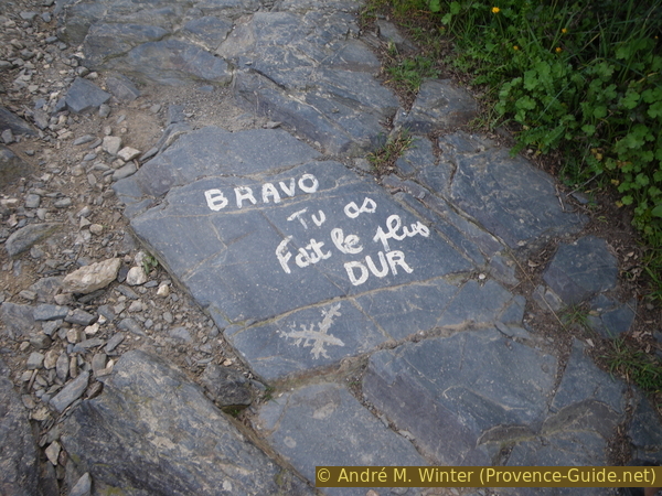
Bravo, the worst is over
Section 5: Sémaphore - Pylône - Montjoie
➙ 2,4 km ... 50 min ➚ 50 m ➘ 150 m ↝ easy
40% dirt roads, few marks
60% easy trails, with marks
The clues
- Follow the forest road past the chapel and the television tower
- Take the path you used on the way there, but turn right after 100 m
- Stay on this marked trail to Montjoie, with a detour in the middle
Back at the top of the ridge this time.
No reproduction is permitted without the written consent of the author. (id3285)
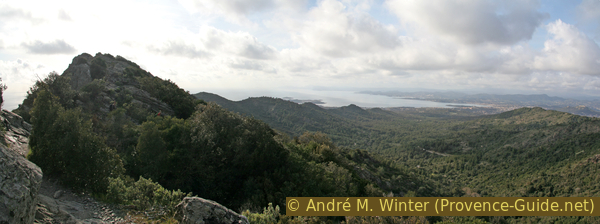
Montjoie ridge in the Cap Sicié massif
pylône = transmission mast
ND du Mai = church Notre-Dame-du-Mai
poste de tirs = fire control centre
pointe = cape
This upper trail follows the north of the ridge line, but still offers some sea views. There are a few counter climbs, but basically it's downhill, sometimes rugged and through washed-out ravines.
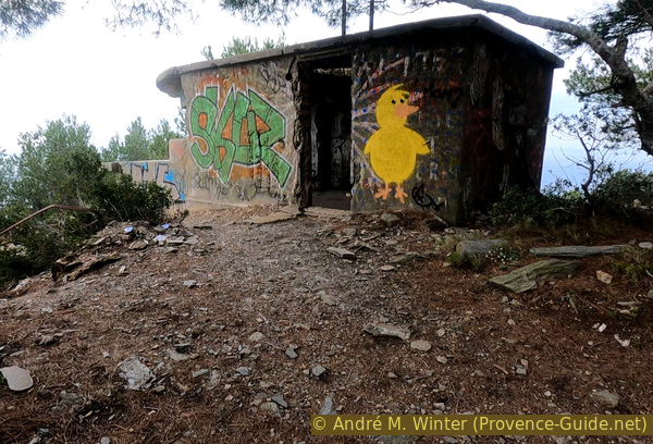
After about twenty minutes of easy walking, a path branches off to the right, which we ignore. 30 meters further a level path leads to the left. We follow this and come across a ruin with strange openings. It is a former control post for directing gunfire and telemetry.
No reproduction is permitted without the written consent of the author. (id5896)
Former firing and telemetry direction station
This is the last chance for us to look back down the rugged slope.
We now return to the main path and before that we continue leisurely to the west, i.e. to the left. After about 10 minutes, however, it leads much steeper down the slope to the left. Finally, it also leads over steps. Below we get to the well-known path of the beginning of the tour.
No reproduction is permitted without the written consent of the author. (id5897)
Notre Dame de Mai chapel and Pointe du Cap Vieux
Section 6: Montjoie - La Lèque
➙ 2,3 km ... 45 min ➚ 45 m ➘ 130 m ↝ easy
45% easy trails, few marks
25% forest roads, with marks
30% hard-surfaced quiet side streets, few marks
The clues
- From Montjoie down and over the Pointe de l'Éperon
- Follow the white marked path
- North along the Chemin des Cargadoux
At the end just return the same way.
ligne = bus line
vers = to
We are now on the path of the ascent and thus come back to the starting point in Haute Lèque. Some will go back to their car, others will walk on to the bus, more detailed information can be found under public transport.
No reproduction is permitted without the written consent of the author. (id3275)
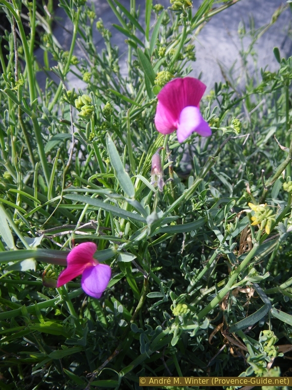
Flowering broad-leaved vetchling
Sources and additional information
This hike is inspired by this book: "Sentiers du littoral méditerranéen: Randonnées de Marseille à Saint-Tropez" ("Mediterranean coastal paths, hikes from Marseille to Saint-Tropez"), by Pierre Garcin and Nicolas Lacroix, Glénat publishers, Montagne Randonnée series, ISBN 987-2-7234-6259-4 (only in French). If you are interested in other sections of the coastal path, this book will help with good directions, lots of nice photos and maps. However, the coastal sections are described linearly from west to east and no round trips are offered.
It is better to use a good topographic hiking map: the tour is on the IGN map "Toulon, Le Gros-Cerveau, Mont-Faron", scale 1:25000, 3346OT.
If you don't want to bother with a paper map, you can also use mapping apps on your cell phone. On the one hand, it is the Cartes IGN app from the official map service. However, it requires access to the data network and this is sometimes difficult in canyons or remote locations.
Alternatively, you can use apps that store data directly on the device. They're generally not free, but they don't cost much. We mainly use OSMAnd, here it is possible to add contour lines, relief shading, markings and others. To store this data on your phone you need a lot of space.
Of course, one needs access to satellites for the GPS signal with any app. In some canyons this is not the case. Therefore, do not rely on the position shown, but read the map on your phone as you would read it on paper. Most apps are available for Android and iPhone. The applications usually allow us to record the route travelled and also view the GPS files offered for each of our hikes.
This page has been seen 4430 times since 20 March 2024.
No reproduction is permitted without the written consent of the author. (id3257)
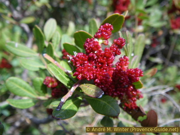
The mastic tree, a typical Mediterranean plant