Round tour of the west cape of Giens
Wild and unspoilt coast on the Hyères peninsula
hike
easy
2 h 45 min
yes
yes
no
mountain
Introduction
The Mediterranean Coastal Path (Sentier du Littoral méditerranéen) is one of the highlights of hiking in the region. There is also not one path, but many different sections with different characteristics and levels of difficulty. On all sections it remains the same that you walk on old paths, as close as possible to the water and through the most beautiful stretches of the coast. Giens is a large, flat peninsula, only at the southern cape does a small rock massif rise up. However, it is too big to be circumhiked comfortably in one day. The western end can be easily designed as a round trip, only a small section has to be crossed in the interior of the island. The paths are in good condition and well marked, they usually stay further behind the edge. The old facilities at the Pointe d'Escampo-Barriou are impressive. One can explore the ruins and descend to the water. There are several beaches along the way, in summer it makes sense to take bathing suits with you.
The facts
6,8 km total distance
2 h 45 min walk time
290 m total elevation
orientation easy
mark 85% of the total distance
70% easy trails
10% hard-surfaced quiet side streets
10% exposed trails
5% stairs
5% forest roads
dangers exposed path, derelict military installations
children yes
useful picnic stuff, swimwear
required hiking boots, hiking equipment and water
GPS coordinates (WGS84) of start and end point 43.039993,6.10397
downloads ![]()
![]()
No reproduction is permitted without the written consent of the author. (id3211)
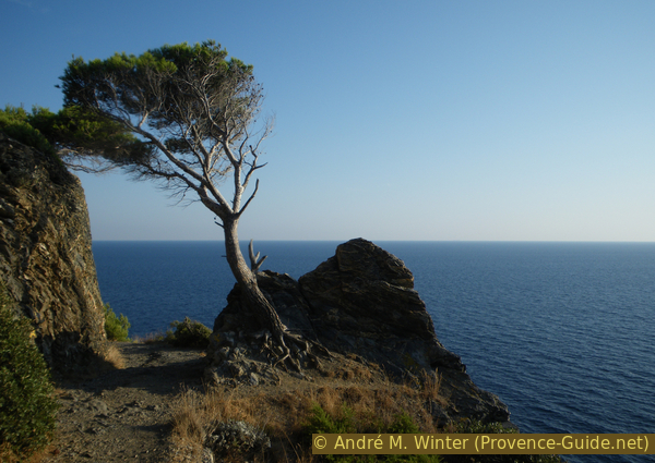
Scots pine on the coastal path of the Hyères peninsula
View on the sea, further behind lays Algeria...
Public transport
The bus line 67 departs from Hyères SNCF train station towards Presqu'île d'Hyères, 12 times a day in summer and around 6 times a day in winter. This is how you get to the village of Giens, which is about 3 km from the starting point. Unfortunately, line 68 does not cross the west-east southern part of the peninsula as often as the other line: 6 times in summer and only 2 times in winter (Tuesdays and Thursdays only). The best way to switch from one bus line to the other is at the Renée Sabran bus stop. The hike begins at the Le Four à Chaux stop on line 68. Timetables for these connections can be viewed at Réseau Mistral (only french).
The peninsula is flat and there are some bike paths. If you want to come here on a bike, it is better to take the road to the west of the old salt pans.
In winter, when you can only get to the village of Giens with line 67, you have to calculate an additional hike time of two times an hour. It is best to take the coastal path in the south of the peninsula to Les Darboussières beach, on the north coast you would have to follow asphalt roads all the time. To get to the Tour from Giens: go to Place Saint-Pierre, pass the church and at the end of the square, go down the Escalier Rompicuou stairs on the left. Bottom right and follow the narrow street Chemin du Béton between the villas. Coming from the Renée Sabran station, go straight ahead and go up Boulevard Édouard Herriot and go down the first street on the left (Chemin du Béton). In front of an archway with all sorts of prohibitions, go down to the left. At the end of the road begins the hiking trail that leads past the Port du Niel and the Pointe des Morts cape to the Plage des Darboussière. Turn right here and you are on the last short section of the hike described here. Return at the end of section 3.
Access by car
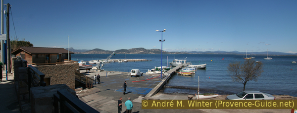
Hyères is a large city east of Toulon. From the wide avenue of palm trees in the center follow the signs to Giens, Les Îles. You drive along the industrial area, the airport, the pines of La Capte on the left and the old salt pans on the right. The road leads through a bland section and immediately encounters a large roundabout. Here on the right, follow the arrows to La Madrague. Now you are back at the sea and after a small port on the right you should look to find a place for your car to park. The tour starts at the following crossroads, here is also the bus stop Le Four à Chaux.
Useful parking spaces
In La Madrague, after the shops and the port, there is a dusty car park to the left of the road. The only other option: the car park at the end of Chemin de la Table Ronde, accessible opposite the exit to the port. There are no other parking spaces. In summer you should come as early as possible.
No reproduction is permitted without the written consent of the author. (id3204)
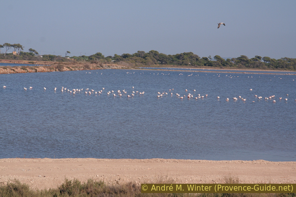
Flamingos at the Étang des Pesquiers
The Hyères peninsula consists of former salines.
Hints
This hike leads mostly through the low maquis in the coastal area. You can find shade, but it won't really cool you down in summer. However, there is often a stiff breeze. You can often descend to the water. There are neither drinking water nor shelters along the way.
Signed locally as Sentier du Littoral, the trail is managed and maintained by the Conservatoire du Littoral, a government nature conservation agency. In some areas there are barriers that force people to take detours because they want to green up bare areas again. Such low fences are mainly seen up to the Pointe des Chevaliers. Sometimes they look like railings, but they are in no way fall protections, there is nothing to be seen in the rockier areas. After the Pointe des Chevaliers there are only markings and no more safeguards. It is particularly steep around the ruins at Escampo-Barriou.
This loop is designed to complement the Loop around the Eastern Cape of Giens. Nevertheless, the tours do not connect well. The main reason is a large section that has to be bypassed over a wide area. It's not a military area, it's a hospital, but that doesn't make things any better.
The whole region is a zone with a high risk of forest fires. In summer, but also in other seasons when it is very dry or by strong winds, access to the forest areas can be regulated. As a result, the roads may be closed to traffic and/or the trails prohibited to hikers. Current information: Map of access to the forests of the Var (also english). The map shows the colours green, yellow, orange and red which correspond to levels of danger.
The sections
- North coast with beaches from La Madrague to Pointe des Chevaliers
- Steep west coast from la Pointe des Chevaliers to Pointe d'Escampo-Barriou
- Exposed south coast from Escampo-Barriou to Plage des Darboussières
- Through the peninsula to the starting point from Plage des Darboussières to La Madrague
No catering facilities along the route.
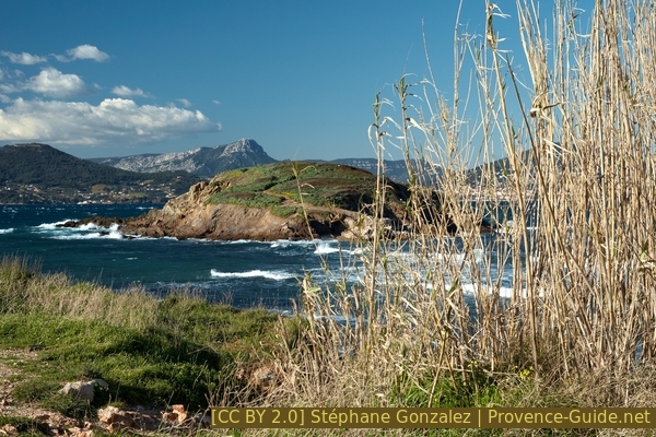
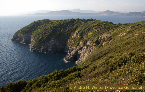
Île de la Redonne island and Le Coudon mountain in the background
Section 1: Calanque du Four à Chaux - Pointe des Chevaliers
➙ 1,6 km ... 45 min ➚ 25 m ➘ 20 m ↝ easy
100% easy trails, few marks
The clues
- Proceed to the path on the coast
- Walk along the north coast to the cape at Île Longue
- Continue to the Pain de Sucre at the Pointe des Chevaliers
We leave the last beaches behind to get into the wilder part of the peninsula.
No reproduction is permitted without the written consent of the author. (id3205)
Calanque du Four a Chaux in Giens
île = island
calanque = bay
zone militaire = military area
After the small port of La Madrague and after the car park, there is a small crossing with a bus stop (Four à Chaux). A short road leads to the sea on the right, but it is closed off with a thick gate. However, there is a footpath to the left of the gate and along the fence over old concrete terraces. Not far behind is the wide bay of the Calanque du Four à Chaux on the north-western shore of the Giens peninsula.
No reproduction is permitted without the written consent of the author. (id3206)
Last beach on the north coast
The ground here is earthy and the shallow beaches are only below the edge of the terrain. You can either walk down the beach or more easily up the wide path. This continues west, in summer this is the footpath to the beaches of this short stretch of coast. Before that, in the coastal area, a first island: the round Île de la Redonne.
The path descends to a final smaller beach and then becomes a bit more challenging. Here only the hikers go further to the western side of the peninsula
No reproduction is permitted without the written consent of the author. (id3251)
Northwest coast of Giens
You step on a nameless cape, in front of which there are a number of other islands. These rocky islets make the hike interesting in stormy weather. The first is Île Longue, behind is Île de la Ratonnière.
At the cape the path turns left and now we head south along the rocky west coast. It's now a little more uphill and downhill. Here there is another possibility to descend through a shallow valley to the sea, later that will be impossible. Do not go left into the interior of the island, here there are only private, military and forbidden areas.
No reproduction is permitted without the written consent of the author. (id3207)
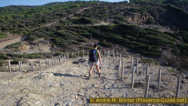
Greening trials on the coastal path
Down in the surf area, rocks are thrown around, the coast section no longer offers nice beaches. The path leads through low maquis, sometimes you can leave the path and look down over the edge of the rock, but the rock is not solid everywhere.
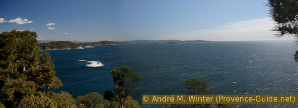
We come to another cape, in front of it there is a white rock with the name Pain de Sucre (Sugar Loaf) in the water. The Pointe des Chevaliers is the peninsula's most westerly cape, with good views westwards on the Cap Sicié and Saint-Mandrier peninsula. The white dissymmetric summit to the right is Le Coudon.
No reproduction is permitted without the written consent of the author. (id3208)
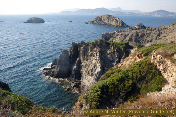
Île de la Ratonnière and Île Longue islands
Section 2: Pointe des Chevaliers - Escampo-Barriou
➙ 1,7 km ... 45 min ➚ 110 m ➘ 100 m ↝ average
60% easy trails, few marks
20% exposed trails, few marks
20% stairs, without marks
The clues
- Continue on the marked hiking trail
- Circle the steep bay of Calanque du Blé
- Forward to the ruins of Escampo-Barriou
The way stays higher now.
No reproduction is permitted without the written consent of the author. (id3210)
Pointe des Chevaliers cape in retrospect
The coast here is very steep and rugged. The Calanque du Blé is a deep basin where westerly currents crash against the rocks. Our coastal footpath runs high above it, the plant cover is a little denser and higher here, so you walk through tunnels in the bushes. The path follows the natural conditions, some times it is very close to the abyss.
No reproduction is permitted without the written consent of the author. (id3209)
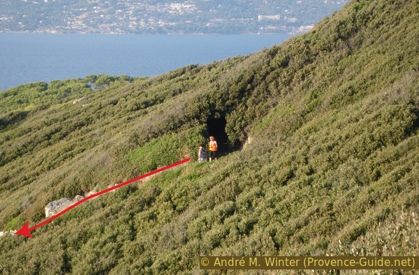
Plant tunnel on the coastal trail in Giens
pointe = cape
zone militaire = military area
escalier = steps
embarcadère = pier
poste lanterne = historic lighthouse
After skirting the rocky cove, the path descends to the Pointe des Salis, the south-west cape of Giens. The names of the promontories and coves here are confusing because on Cape Pointe des Salis stand the ruins of the Phare d'Escampo-Barriou lighthouse, although Cape Pointe Escampo-Barrio is the next promontory. To confuse things even more, there is also a beach called Plage d'Escampo-Barriou, but it's even further east behind the Pointe du Rabat.
No reproduction is permitted without the written consent of the author. (id3212)
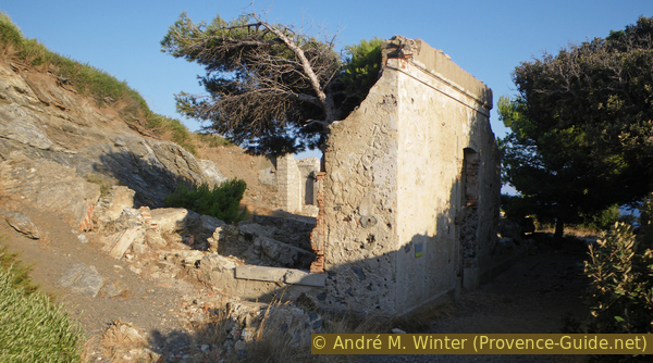
Ruins on the Pointe d'Escampo Barriou
But even without paying attention to the names, we come to a crossroads at the remains of walls and ruins. The coastal path continues to the left above, straight ahead you pass a ruined building, followed by flat areas with remains of military installations. But it pays to go here, the installations closer to the cape are in better condition than up here.
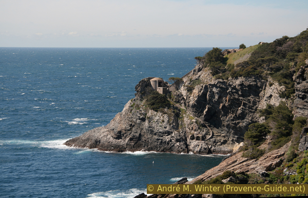
The facility was originally a lighthouse operated by a local power station before electrification (hence the name photo-electric post, the elevators were used to supply fuel). These facilities were also armed and the destroyed areas higher up were last used in World War II.
The more interesting areas, the stairs and ramps are only poorly secured. After flat areas, you are faced with a steep brick ramp, where an inclined lift used to be installed. What remains today is a narrow stairway that descends to the top of an underground vertical elevator. Above it is a platform with a comprehensive view. There is another very similar facility further west on Cap Sicié.
No reproduction is permitted without the written consent of the author. (id3213)
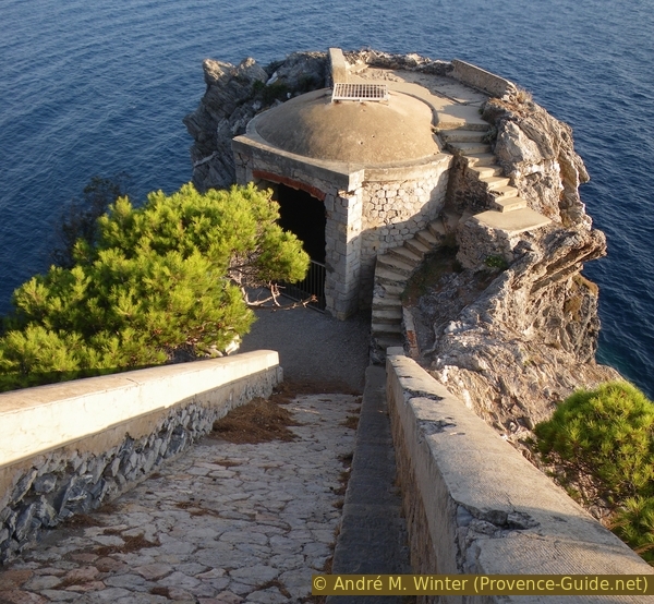
Lift and ramp on Pointe Escampo-Barriou
But that's not all, you can also descend to the old jetty if you first climb over a wall. The steps there consist of large blocks of lime, which lead here in a large arc over the rather rugged rock. So you almost go into a sea grotto and come to an old shelter just above the water. However, the place is not suitable for swimming.
Then back up to the fork in the path.
No reproduction is permitted without the written consent of the author. (id3214)
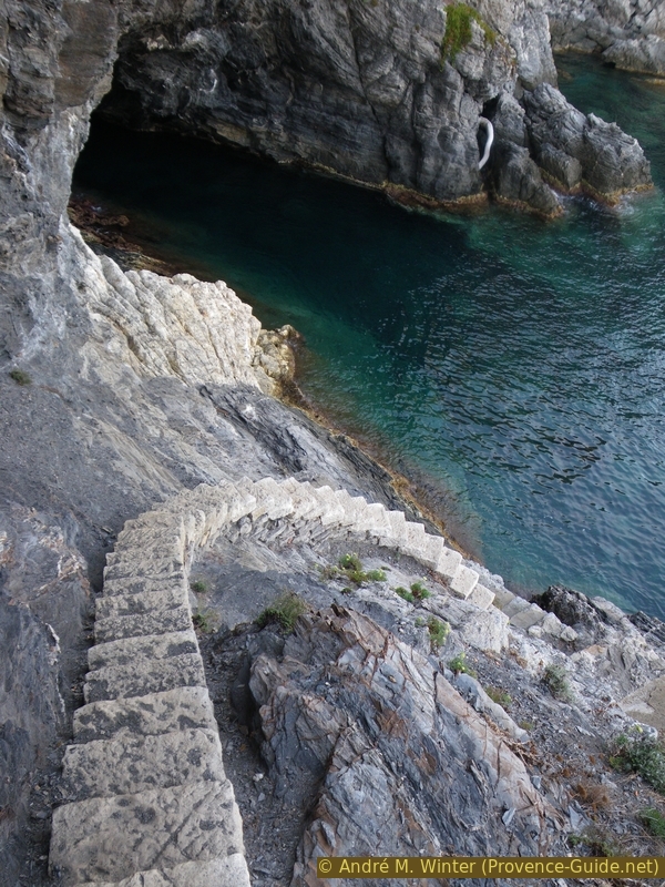
Stair in the Calanque d'Escampo-Barriou
Section 3: Escampo-Barriou - Plage des Darboussières
➙ 2,4 km ... 1 h ➚ 135 m ➘ 150 m ↝ average
85% easy trails, few marks
15% exposed trails, few marks
The clues
- From now on further east
- Pass the Cape Pointe du Rabat
- Pass the Plage d'Escampo-Barriou beach
- Pass over the Pointe du Pignet cape
- Continue to Plage des Darboussières beach
The south coast is more strenuous, the path goes up and down, it is more exposed and the path can be slippery. But here we are still away from the hordes just looking out for short ways to the beach.
No reproduction is permitted without the written consent of the author. (id3252)
View back on the facilities at Escampo-Barriou
Immediately after the cape with the ruins, the path gets worse because the rock is more crumbly here. Apparently, the course has been relocated several times and the path now leads quite high above the Pointe Escampo-Barriou. Descents to the water are not possible here. From the Pointe du Rabat there is a good look back at the stairway to the sea at the previous cape.
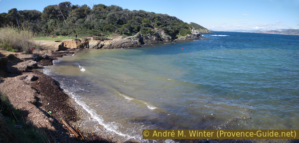
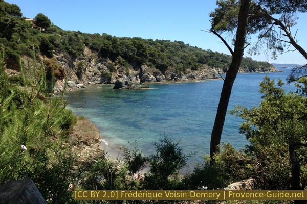
The Pointe du Rabat is a wooded cape, the trails are better here. Only when descending to the Plage d'Escampo-Barriou beach (also Plage du Pontillon) do you have to scramble over rocks. It is advisable to take advantage of the beach for a longer break, it is the only beach on the section and also the last before the Plage des Darboussières. There will be a lot more people there because it's quick and easy to get here from La Madrague. As before, do not take any paths to the left and inland, there is a military restricted area at the top.
After that, the path is easier, even if it is bumpy at times. We keep going east and also circle the Pointe du Pignet. This is the last little cape to pass, further along the coast is more straight.
No reproduction is permitted without the written consent of the author. (id3253)
South coast of the peninsula of Giens
calanque = bay
pointe = cape
chemin = path
sentier littoral = costal trail
plage = beach
zone militaire = military area
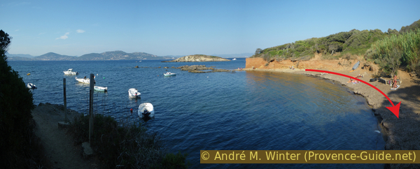
We come to the bay with the Plage des Darboussières and now there are two options: at the level of the Pointe de la Galère, cut straight north, this is an unmarked path through the pine forest. Or go further to the beach. It gets quite busy here in the summer, even if the strip of sand is quite narrow, but the water here is always crystal clear and it's worth the little detour in the off-season.
Bay of the Plage des Darboussières
Section 4: Plage des Darboussières - La Madrague
➙ 1,1 km ... 20 min ➚ 20 m ➘ 20 m ↝ easy
30% forest roads, few marks
70% hard-surfaced quiet side streets, without marks
The clues
- Up the road behind the Plage des Darboussières
- Pass the parking lot
- On the larger road to the left
- Return to the starting point
The last section of the tour is a classic dusty way to a beach.
A map to this section is slightly higher on this page.
No reproduction is permitted without the written consent of the author. (id3254)
Port of La Madrague
After a few minutes you will come to the beach car park and continue along Chemin de la Table Ronde to avenue René de Knyff. This is the extension of the Route de la Madrague. Opposite are the jetties of the small port.
Sources and additional information
This hike is inspired by this book: "Sentiers du littoral méditerranéen: Randonnées de Marseille à Saint-Tropez" ("Mediterranean coastal paths, hikes from Marseille to Saint-Tropez"), by Pierre Garcin and Nicolas Lacroix, Glénat publishers, Montagne Randonnée series, ISBN 987-2-7234-6259-4 (only in French). If you are interested in other sections of the coastal path, this book will help with good directions, lots of nice photos and maps. However, the coastal sections are described linearly from west to east and no round trips are offered.
It is better to use a good topographical hiking map: the tour is on the IGN "Hyères, Île de Porquerolles" map, scale 1:25000, 3446OT.
If you don't want to bother with a paper map, you can also use mapping apps on your cell phone. On the one hand, it is the Cartes IGN app from the official map service. However, it requires access to the data network and this is sometimes difficult in canyons or remote locations.
Alternatively, you can use apps that store data directly on the device. They're generally not free, but they don't cost much. We mainly use OSMAnd, here it is possible to add contour lines, relief shading, markings and others. To store this data on your phone you need a lot of space.
Of course, one needs access to satellites for the GPS signal with any app. In some canyons this is not the case. Therefore, do not rely on the position shown, but read the map on your phone as you would read it on paper. Most apps are available for Android and iPhone. The applications usually allow us to record the route travelled and also view the GPS files offered for each of our hikes.
This page has been seen 881 times since 20 March 2024.
No reproduction is permitted without the written consent of the author. (id3215)
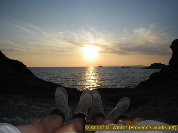
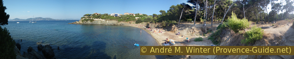
Legs of hikers in the sunset over Cap Sicié