Through the oak forests to the Notre-Dame de Bellevue chapel
From Tavernes over the dry valleys to the panoramic view mountain
hike
easy
3 h 30 min
yes
yes
no
mountain
Introduction
Provence is the land of mountain chapels that offer magnificent views of beautiful surroundings. This is also the case with Notre-Dame de Bellevue on the hill north of Tavernes. It can be reached quickly via an old straight Way of the Cross. But this is not very exciting and inevitably very hot with a purely southern orientation. There is a way to get to the chapel via the Ubac de la Colle and at the same time explore what gives Provence Verte its name: the oak forest and the fountains. We approach by taking a detour through the olive groves to the west of Tavernes.
We are here in the limestone region and pass very dry and deserted valleys. We notice the numerous trees overgrown with lichen. Even if everything seems dry, there is still water. It flows under the dry creek bed as groundwater and appears in the form of light fog during the night.
On Thursday mornings you can get your snack at the Tavernes market!
The facts
10,8 km total distance
3 h 30 min walk time
330 m total elevation
orientation challenging in the long unmarked section
mark 35% of the total distance
40% hard-surfaced quiet side streets
25% forest roads
15% in the riverbed
5% hard-surfaced city alleys
5% dirt roads
5% easy trails
5% cross country
dangers of heat in summer, hunting in autumn
children if they have appropriate walking experience
useful picnic stuff
required hiking boots, hiking equipment and water
GPS coordinates (WGS84) of start and end point 43.593238,6.014366
downloads ![]()
![]()
No reproduction is permitted without the written consent of the author. (id3745)
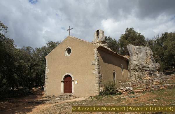
Notre-Dame de Bellevue chapel
The rock forms the apse and supports the bell tower.
Public transport
There is no viable public transport for this hike. Only school transport is available. It ist useful to complain about at the tourist offices of the region.
Access by car
Tavernes is on a plain north of Brignoles and Barjols. The tour begins and ends just west of the centre near the post office and on a bend in the main road.
Useful parking spaces
There is a central car park west of the centre near the post office and on the bend in the D554 road and other spaces near the school and next to the cemetery. The latter is in the course of the tour.
Hints
There is no spring with drinking water on the route, so make sure you have enough to drink! A large part of this tour is not marked, one must pay enough attention to all crossings and should not hesitate to use the GPS file provided. With the exception of the Way of the Cross leading downhill, most of the tour takes place on old paths and abandoned forest roads.
We are in a rural part of Provence where the locals love to go hunting, especially in autumn. The presence of hunters can be easily recognized by the number of cars (often white) parked at points that can also be reached without a four-wheel drive. The hunters, dressed in fluorescent safety vests, are often positioned in groups along the forest roads and open areas, rarely far from the cars. Don't hesitate to shout if you think you're in the presence of an active hunter. In the area covered, this may affect the Souates forest road and the Route de Bury, which we follow for a short moment.
The whole region is a zone with a high risk of forest fires. In summer, but also in other seasons when it is very dry or by strong winds, access to the forest areas can be regulated. As a result, the roads may be closed to traffic and/or the trails prohibited to hikers. Current information: Map of access to the forests of the Var (also english). The map shows the colours green, yellow, orange and red which correspond to levels of danger. The affected area is: le Haut Var (3).
The sections
- Tavernes - Puits du Suy: forest and dry valleys
- Puits du Suy - Chapel N.-D. de Bellevue: the ascent
- Chapel N.-D. de Bellevue - Tavernes: steep descent and the village
Bistros and restaurants are only available in the village of Tavernes. A grocery store is located in the main square.
No reproduction is permitted without the written consent of the author. (id3731)
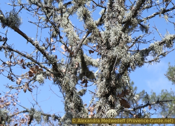
Oak branches with lichen
Section 1: Tavernes - Puits du Suy
➙ 5,3 km ... 1 h 30 min ➚ 180 m ➘ 55 m ↝ average
20% hard-surfaced quiet side streets, faulty marks
10% dirt roads, without marks
35% forest roads, without marks
30% in the riverbed, without marks
The clues
- Tavernes, 365 m
- Height spot 409 m
- Puits du Suy, 485 m
We leave the village through the olive groves to go further into the Provençal forest and the dry valleys.
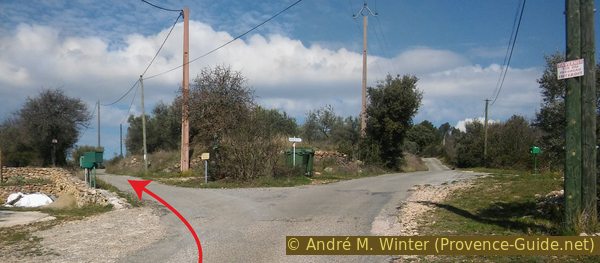
poste = post office
The tour starts in the bend west of Tavernes. One immediately leaves the main road to head north onto Chemin de Braou, here in the form of a narrow road between a detached house and the rest of the town centre (30 km/h sign). The Notre-Dame de Bellevue chapel is also signposted here.
No reproduction is permitted without the written consent of the author. (id3728)
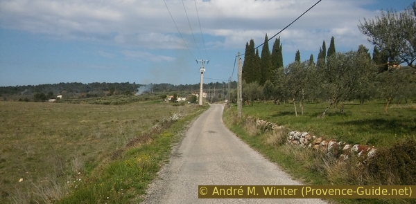
Chemin de Braou and the cypresses of the Way of the Cross
You will stay on this small street for a quarter of an hour, first under an avenue of plane trees, then more openly. You pass the cemetery and keep turning west. There are fields and olive groves on both sides of the road. On a long straight stretch, cypress trees stand on the right, indicating the old Way of the Cross that leads up to the chapel. This is where we will come down at the end of the tour.
In an ascent is a fork, we take the narrower road on the left, it is the Chemin du Grand Clos. After a few metres this becomes a dirt track between rows of olive trees, which are still actively cultivated here. After a depression (the slope is concreted), the path leads up into the forest. You always stay on the path to the west and ignore the driveways to two houses on the right. The one with the fence by the wayside is guarded by geese.
No reproduction is permitted without the written consent of the author. (id3729)
Fork between Chemin du Grand Clos and Chemin de Braou
In the forest and after the houses, the forest road becomes more impassable, it is now oriented a little more to the north-west, not without making a few curves. After the junction of forest roads on the right hand side, an old path leads to the left of the forest road more directly in a westerly direction. We take this for about 300 metres. The path then leads to the right on a rough and steep forest road in a slope. We continue on this forest road, which turns north to take us into one of the many dry valleys in the region.
No reproduction is permitted without the written consent of the author. (id3730)
Chemin du Grand Clos leads into the forest
cote = elevation point
The continuation of our path is a vague forest road that more or less follows the valley floor. We go on it in a downward direction (here south-west) and ignore the paths that appear on the right.
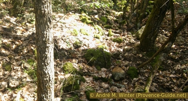
In these valleys we find the typical Provencal oak forests. They are often covered with lichens, witnesses to the presence of water, even if everything seems dry.
No reproduction is permitted without the written consent of the author. (id3732)
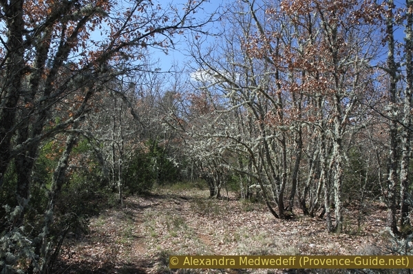
Dry valley north-west of Grand Clos
Our next stage is a confluence of dry valleys. On the IGN map this point is marked with 409 metres and here we turn right to hike up the parallel valley.
The valleys are so remote that they don't even have names. In earlier times it was customary to give precise names to places where water could be found. These places still bear these names today, but not here due to the lack of water.
No reproduction is permitted without the written consent of the author. (id3733)
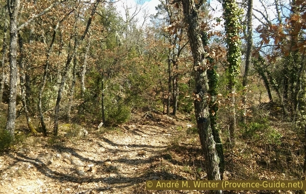
Valley north of elevation point 409
We walk up the valley along the meanders of the dry riverbed, we follow the north-north-east direction. Gradually, the stony river bed turns into a forest road. Valleys and forest roads come down from the left, but we stay on the valley floor.
No reproduction is permitted without the written consent of the author. (id3734)
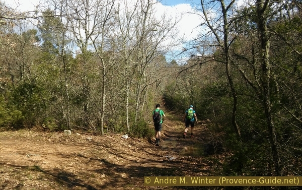
Forest road south of Les Souates
puits = well
virage = curve
cote = elevation point
ubac = north slope
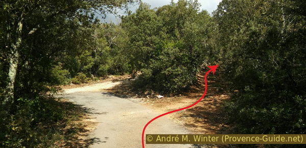
At elevation 441 metres non the IGN map, we still stay to the right and then turn east. The forest road now rises noticeably and leads to a tight right-hand bend at height mark 480 metres. On the outside of the curve there is another less-used forest road, which we now take.
No reproduction is permitted without the written consent of the author. (id3737)
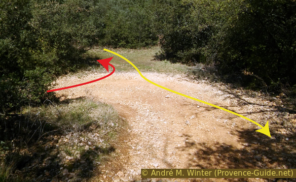
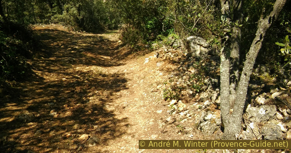
Curve of the forest road at Les Souates
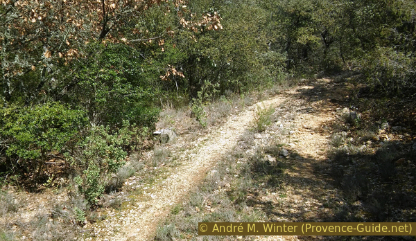
View of the path leading to Puits du Suy. Here it is overgrown with grass.
A few metres after this crossing, the forest road begins a long right turn. Even in the curve, the forest road rises more clearly. At that moment you can make out a pile of gray bricks to the left, or what used to be an ancient path just ahead of these bricks. This path is still marked on the IGN map, but it is very difficult to see in nature. We go down between the bushes into a hollow and then find an old well on the right under the bushes.
No reproduction is permitted without the written consent of the author. (id3735)
Gray bricks indicating the approach to Puits du Suy
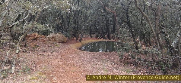
You have to descend a few meters before the bricks.
If we look under the makeshift lid, we quickly see that there is water.
Neither the well nor the place are anything special, but these are wells that made it possible to cultivate dry and calcareous soils. You can also see some old cultural terraces here and there in the maquis. Not only are these terraces built to hold back the earth, but they often take advantage of the shape of the outcropping rock. So the cultivated soil can be significantly deeper than the walls are high.
No reproduction is permitted without the written consent of the author. (id3736)
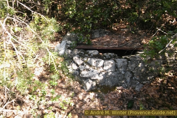
Puits du Suy well
Section 2: Puits du Suy - N.-D. de Bellevue
➙ 2,5 km ... 1 h ➚ 140 m ➘ 25 m ↝ average
20% forest roads, with marks
65% hard-surfaced quiet side streets, without marks
15% cross country
The clues
- Puits du Suy, 485 m
- Curve with bridge, 470 m
- Notre-Dame de Bellevue, 625 m
Ascent over the northern slope to the chapel.
The meadows around the well are overgrown with macchia and forest, but you can take a break directly on the forest road. Then we go back to the crossroads in the curve and continue the ascent on the previous forest road. After about 400 metres we find a paved road: it leads north to the Hameau de Bury and south to Tavernes. We turn right, it goes slightly downhill here. We follow the loops of the road and descend into a valley further east.
No reproduction is permitted without the written consent of the author. (id3738)
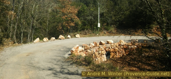
Curve of the Route de Bury with bridge
Immediately after the curve, a path branches off to the left.
pont = bridge
ligne électrique = power line
citerne = water tank
chemin de croix = Way of the Cross
The road crosses the valley in a right turn and a few metres later we enter a wooded valley that turns left at a right angle from the road. A path leads up the valley floor and we enter a dark and dense forest. After about 200 metres the path is completely lost and we continue without a trail in the same direction, always a little uphill. We pass big heaps of stones that were piled up during the past centuries when people tried to turn the dry land into pastures. At the moment when you think you can't go any further and when the slope becomes much steeper, you're already on the embankment under a paved road that you have to climb up. There we continue to the left. Do not continue across the raod into the deforested area, this forest track leads nowhere.
No reproduction is permitted without the written consent of the author. (id3739)
Connection trail between Route du Bury and forest road at Ubac de la Colle
If you don't want to mess around in the garrigue, you can avoid this shortcut by continuing south on the road to the crossroads with the fire cistern. There you turn left onto another road that is partially paved. This extends the path length by around 600 metres.
Less than 100 metres after coming up from the shortcut, the road leads to a junction with multiple branches. There you have to take the first forest road that leads up to the right, roughly in a north-north-east direction. Here are some patches of blue paint instead of a marker to find the spot.
No reproduction is permitted without the written consent of the author. (id3740)
On the right the start of the forest road at Ubac de la Colle
You go up into a dense forest (at least until the clearing continues here too) and quite straight. At the moment when the forest road flattens out, you see a power line.
No reproduction is permitted without the written consent of the author. (id3741)
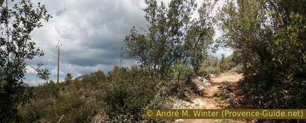
Forest road at Ubac de la Colle and power line
Here you have to take the first forest road on the right, which branches off to the south-east. Don't go straight ahead, all paths end in the impenetrable forest. The course of the old path on the IGN map at Ubac de la Colle is wrong!
No reproduction is permitted without the written consent of the author. (id3742)
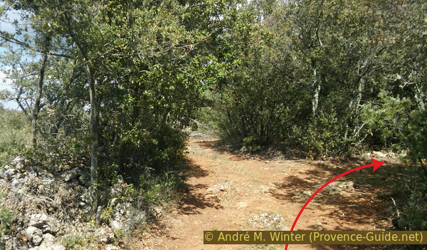
Fork towards ND de Bellevue on the right
Our forest road climbs and makes some curves to get to the top of the hill, always taking the most visible forest road at the crossroads. It makes an abrupt turn to the left (a cattle trough on the right) and a little later an old wall appears on the right. We can turn right at the corner of the wall.
No reproduction is permitted without the written consent of the author. (id3743)
Cattle trough on the forest road near Notre-Dame de Bellevue
From now on, coming from the north, we will go straight towards the Notre-Dame de Bellevue chapel.
No reproduction is permitted without the written consent of the author. (id3744)
Arriving at Notre-Dame de Bellevue
There is a bench in front of the chapel for a well-deserved break.
In 1692 a Dominican friar thought he saw a chapel at the top of the hill north of Tavernes. But then he realized it was just a rock. In this error he saw a sign and built a sanctuary that became the destination of numerous pilgrims. The rock serves as the chapel's bell tower and, since 1779, has held the bell that came from the old Barjols hospital. It is possible to climb up to the right side of the bell tower (railing), from there you have a view over the roof of the chapel.
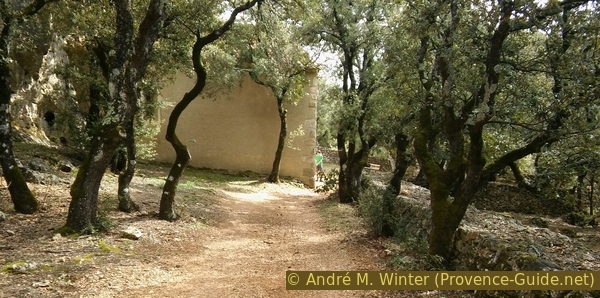
To the right of the chapel there is a house with bricked-up openings.
It served as a hermitage: built in 1643, a year after the chapel, with the funds of Jean de Pontevès, Count of Carcès, who settled here monks of the Royal Monastery of Saint-Maximin. Subsequently, they were replaced by Dominicans until 1856. They also built the dry stone walls to better farm the area.
No reproduction is permitted without the written consent of the author. (id3746)
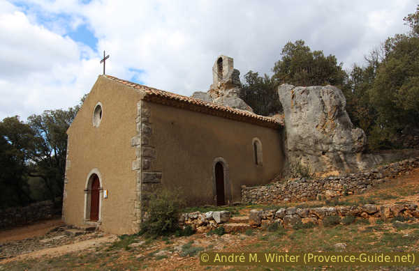
Notre-Dame de Bellevue and the rock of the apse
Some may have noticed that the view is missing, even though it was advertised for this tour and also appears in the name of the chapel itself. For the view you have to continue in front of the chapel and walk a bit south to the edge of the plateau. There a wayside cross awaits us and another bench with a panorama to the south and you have the village of Tavernes at your feet.
No reproduction is permitted without the written consent of the author. (id3748)
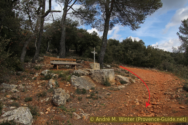
Bench and cross under the chapel N.-D. de Bellevue
View of the mountains Gros Bessillon and Petit Bessillon, the Mont Aurélien and up to the Sainte-Victoire.
No reproduction is permitted without the written consent of the author. (id2929)
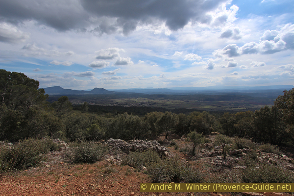
Mountains Gros Bessillon and Petit Bessillon, below Tavernes
Section 3: N.-D. de Bellevue - Tavernes
➙ 3,1 km ... 1 h ➚ 10 m ➘ 250 m ↝ easy
15% easy trails, with marks
10% forest roads, with marks
50% hard-surfaced quiet side streets, few marks
25% hard-surfaced city alleys, without marks
The clues
- Notre-Dame de Bellevue, 625 m
- Tavernes, 365 m
Direct descent to the village.
You should oil your knees well for the last section, as the descent is very steep and rugged. The slope is constant: you cover 230 metres in altitude over a distance of 1,7 km. The old Way of the Cross only exists with a few stations at the top.
Half way down the path widens and later it is also paved. Below, after the cypresses and at the wayside cross, we turn left back to the village.
No reproduction is permitted without the written consent of the author. (id3747)
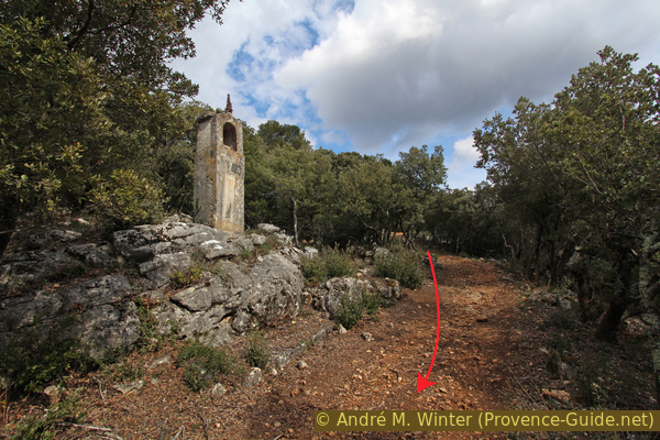
Station of the Cross of the chapel ND de Bellevue
At the end of the avenue Chemin de Braou there is a possibility to go concentrically on the rue du Cimetière into the village. Taking the second street on the left, you turn onto rue du Puits Neuf with its colored houses arranged around the church. Halfway it is better to take a passage to the Place de l'Église to get to the Place de la Mairie. Two bars are available here to quench your thirst.
No reproduction is permitted without the written consent of the author. (id3750)
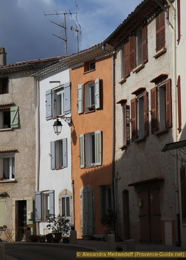
Houses in the centre of Tavernes
The D71 crosses the village without a real pavement, so it is better to take rue du Puits Neuf again next to the Café du Commerce and exit the village on rue du Cimetière towards the bus or car park.
Sources and additional information
It is better to use a good topographical hiking map: this tour is on the IGN "Gréoux-les-Bains" map, scale 1:25000, 3343OT.
If you don't want to bother with a paper map, you can also use mapping apps on your cell phone. On the one hand, it is the Cartes IGN app from the official map service. However, it requires access to the data network and this is sometimes difficult in canyons or remote locations.
Alternatively, you can use apps that store data directly on the device. They're generally not free, but they don't cost much. We mainly use OSMAnd, here it is possible to add contour lines, relief shading, markings and others. To store this data on your phone you need a lot of space.
Of course, one needs access to satellites for the GPS signal with any app. In some canyons this is not the case. Therefore, do not rely on the position shown, but read the map on your phone as you would read it on paper. Most apps are available for Android and iPhone. The applications usually allow us to record the route travelled and also view the GPS files offered for each of our hikes.
This page has been seen 1820 times since 20 March 2024.
No reproduction is permitted without the written consent of the author. (id3751)

Bell Tower and Bar Central from Tavernes