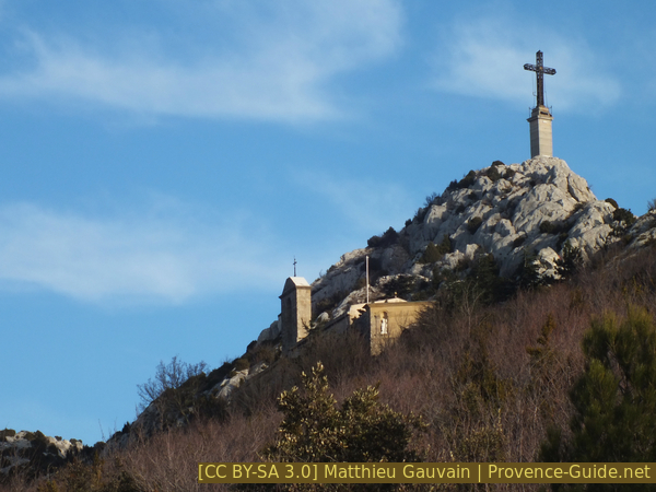
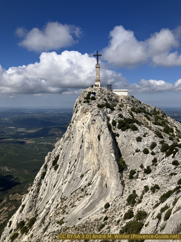
Cross of Provence on the Sainte Victoire mountain by the Pas du Moine
Direct route without climbing, descent via the Costes Chaudes ridge
hike
average
4 h
yes
yes
shelter
mountain
Introduction
The Montagne Sainte Victoire is an emblematic massif of Provence and its fame radiates far beyond. Clearly visible from the city of Aix-en-Provence, it has been painted many times by Paul Cézanne. This limestone mountain, with its almost vertical southern slope, is not only beautiful, it is also an El Dorado for walkers, climbers and other nature lovers. Many people climb it, but it is not a mountain to be underestimated. Regardless of the access chosen, there are 700 meters to ascend. Then it is high in a fairly flat country, therefore very exposed to the wind, particularly to the Mistral. This has demanding consequences. The wind blows on the ridge and the paths are also mostly on these exposed areas. You have to be careful not to fly away and then it can be very cold up there, is particularly the case in winter, we leave in a t-shirt and at the top it is -5°C with a crazy wind. Who says wind also says danger of forest fires, see hints.
This rocky bar extends east-west, you can cross it on the ridge on the GR9 long distance hiking trail, there are some possibilities to ascend on the Montagne Sainte Victoire from the north, which is much less steep. But on the south side, the passages are rare or fall into the difficult climbing category. The Pas du Moine saddle, which we will take to ascend, is the passage without climbing closest to the priory under the Croix de Provence, we pass on a rocky ramp well hidden in the stony slope. For the return we will follow the western ridge called Costes Chaudes and pass again the Cézanne refuge to return to the starting point at the Pont de l'Anchois (also called Plan d'En Chois).
The facts
11,6 km total distance
4 h walk time
750 m total elevation
orientation easy, but without continuous marks
mark 85% of the total distance
55% easy trails
35% dirt roads
5% moderate trails
<5% cross country
<5% exposed trails
<5% Trails with scramble passages
dangers parts exposed to the abyss and at the same time to the wind
children yes, if they follow the instructions in the dangerous parts
useful picnic equipment
required mountain shoes, hiking equipment and water
GPS coordinates (WGS84) of start and end point 43.523178,5.568041
downloads ![]()
![]()
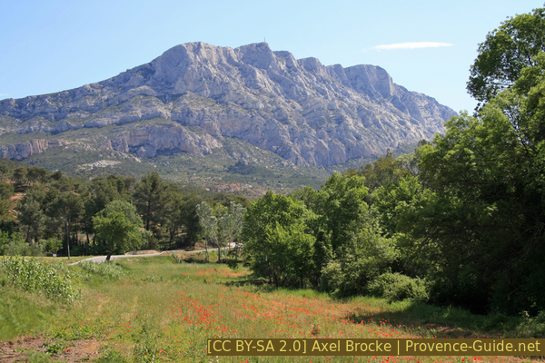
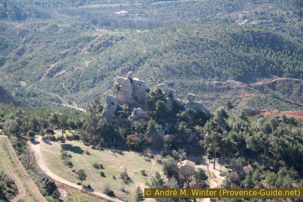
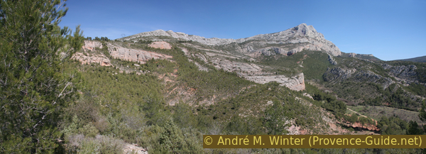
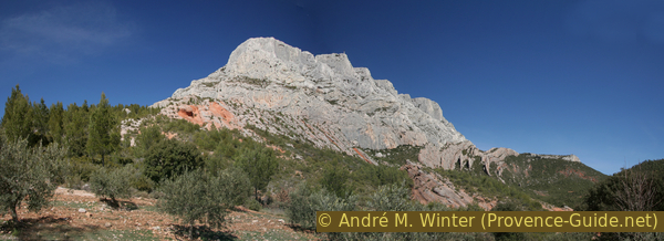
Montagne Sainte-Victoire seen from the D17 road
In the middle our destination: the Croix de Provence summit cross.
Public transport
The area south of the mountain is served by an inter-urban line from the Pays d'Aix region. The bus line 110 goes around the city of Aix-en-Provence then passes as close as possible the south of the Montagne Sainte Victoire to lead to Puyloubier via Le Tholonet, Saint-Antonin-sur-Bayon and Beaurecueil. It is at the Le Bouquet stop, between the last two named stops, that you will have to get off to start the hike at the Pont de l'Anchois. There are around fifteen connections per day during the week and 6 connections on weekends, between 8 am and 8 pm. Information under La Métropole Mobilité (only french), look for line 110 or the Le Bouquet stop under "horaires".
Access by car
The site is east of Aix-en-Provence and it is on the D17 road (Avenue des Écoles Militaires) that you leave Aix and arrive at the start of the hike 5 km behind The Tholonet village. Coming from the east or south, exit the A8 motorway immediately after the La Baraque toll barrier (exit 32), then follow the signs to Le Tholonet. At Pont-de-Bayeux turn right and follow the directions to Beaurecueil. At the roundabout again towards Le Tholonet then at the junction turn right on the D17 towards Saint-Antonin. After 2 km we are at the start of the hike.
Useful parking spaces
There are two car parks to the left of the road, one before and one after the Pont de l'Anchois. They will probably be full during the weekends when you come too late. Do not park on the shoulders, you will automatically be hauled off, the danger is too great that the road may be blocked for firefighters in the event of a forest fire. There are several other car parks along the D17, all of which have marked paths up to Refuge Cézanne which is at the start of the hike described here. These alternatives are detailed below.
Hints
This hiking tour leads over exposed places and follows the windswept crest line for a long time. The ascent from the former monastery to the cross is easy, but definitely problematic for people who are not free from giddiness. These points are particularly important with children. Some narrow passages have smooth limestone. Be sure to bring warm clothing, even if it is pleasantly warm down below, we are climbing just under 1000 m above sea level. Climate and path conditions correspond to those of the high mountains! In winter, the temperatures are negative very quickly, parts of the path are also on the shady side behind the ridge and therefore possibly icy.
At the top of the former monastery, there is a shelter that has been renovated. You can make a fire here, but you would have to carry wood upstairs. The so-called Refuge Cézanne is closed, you can no longer shelter here.
You may also find this other hike of interest: Montagne Sainte Victoire from the north.
The whole region is a zone with a high risk of forest fires. In summer, but also in other seasons when it is very dry or by strong winds, access to the forest areas can be regulated. As a result, the roads may be closed to traffic and/or the trails prohibited to hikers. Current information: Map of access to forests and exposed areas in Bouches-du-Rhône (also english). The map shows the colours green, yellow, orange and red which correspond to levels of danger. The affected area is: Sainte-Victoire.
No reproduction is permitted without the written consent of the author. (id3104)
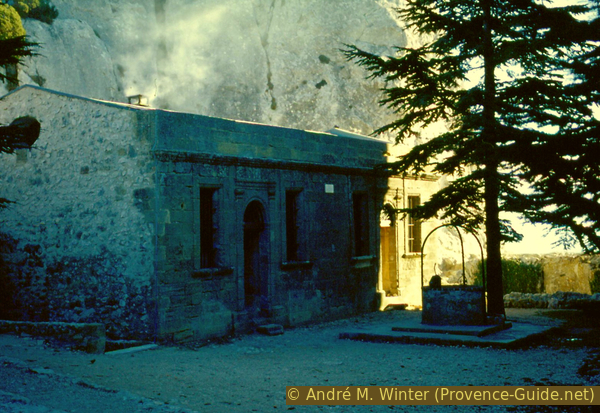
Shelter by the chapel on the Montagne Sainte-Victoire
The sections
- Pont de l'Anchois bridge - Refuge Cézanne - Pas du Moine saddle - Cloister
- Up to the big Croix de Provence cross
- Long descent via Costes Chaudes on Sentier Imoucha trail
- Via Les Roques Hautes and Refuge Cézanne back to Pont de l'Anchois bridge
No source of drinking water on the way, shelter at the former monastery.
Section 1: Parking - Ref. Cézanne - Pas du Moine - Prieuré
➙ 2,9 km ... 1 h ➚ 520 m ➘ 20 m ↝ average
5% cross country
20% dirt roads, with marks
60% easy trails, with marks
5% Trails with scramble passages, with marks
10% exposed trails, with marks
The clues
- From the car park via a forest road to the Refuge Cézanne
- Continue up north
- Keep right and walk towards the first rock face
- Keep left and ascend over the Pas du Moine ramp
- After the ridge, turn right on the normal path to the cloister
The most direct trail to the cloister.
From the car park west of the Pont de l'Anchois bridge, go up the dirt road to start the hike. From the lower parking lot (there is also the bus stop) you have to go under the trees up to the field path. You can't see it from below, tend to keep left, otherwise you'll end up in a wild ditch. Or go west along the road for about 100 m to the other car park, turn right up here.
No reproduction is permitted without the written consent of the author. (id3287)
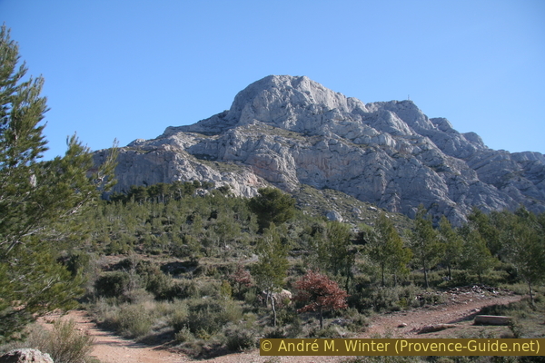
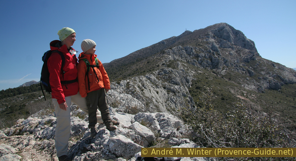
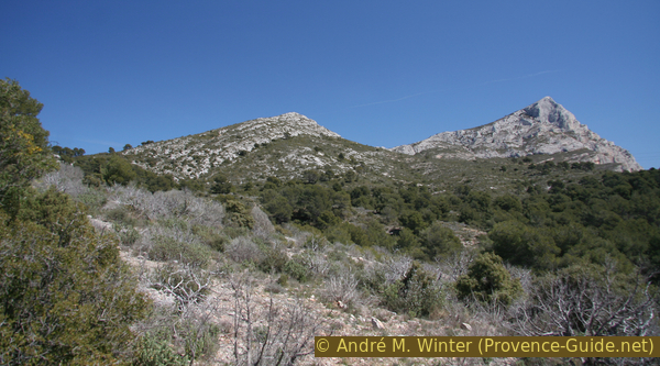
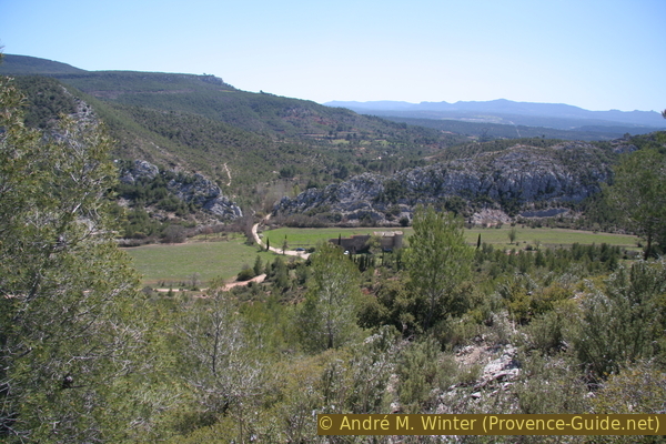
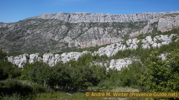
Bau Cézanne and Croix de Provence
View of our mountain from the approach.
vers = to
arrêt = stop
pont = bridge
With these minor arrivimg problems resolved, head straight north and uphill to the closed Refuge Cézanne. You follow a rutted field path and can cut off some hairpin bends on marked sections (point 1b). Don't trample anywhere, the vegetation in the barren area has already difficulties enough without inconsiderate hikers. At the closed shelter (point 1c), there is a striking rock ensemble with a cross on it.
The section is marked in red.
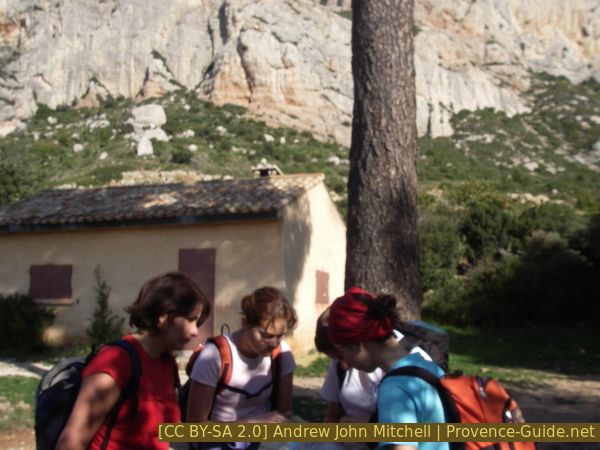
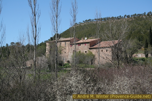
Rest at the Refuge Cézanne
Coming from other car parks or stops:
Further west is a bus stop at the campsite north of Beaurecueil and not far from there north of the D17 road is the l'Aurigon car park. From here, follow the signs to Refuge Cézanne. There is either a field path in front of the parking lot to the right of the access road, or you go to the back to the picnic area and then turn right. That adds 3 km and 1 hour, but much less on the way back. A small map shows the situation in Section 3.
Further east there is a bus stop and car park at the Écomusée Maison de Sainte-Victoire: either across the road straight up the embankment and along the paths over 200 m along the road to the west and take the marked path from there. This takes you to the car park at the Pont de l'Anchois bridge, where the hike described begins. 1.5 km more one way, see also the grey dotted path on the small map above.
pas = (here) saddle
chemin = path
GR = long-distance trail
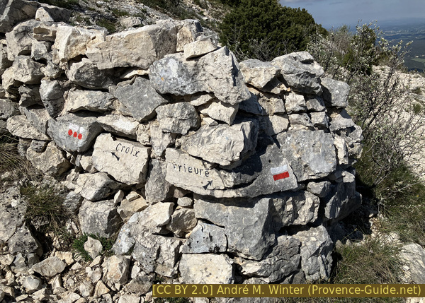
croix = cross
prieuré = priory
From the Refuge Cézanne (1c), we continue to ascend towards the north, following the red marking, leaving behind us the striking rock with the cross. The dirt road becomes a path. This main path is also lined with many side paths, which together lead up into a cirque. It is better to stay on the marked main path, the other tracks usually lead to the start of climbing tours. It goes on uphill and so, keeping a little to the left, we cross the first rock wall. The path then turns right again and seems to be aiming for the insurmountable smooth rock of the Bau Cézanne.
No reproduction is permitted without the written consent of the author. (id3288)
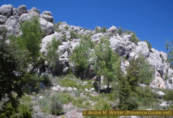
Rocks at Refuge Cézanne
Before you get to this second rocky obstacle, you can choose at a junction (1d): on the left the easier but longer Pas de l'Escalette (marked with red dots on site) or on the right the Pas du Moine (1f, further marked in red): our choice. A short, steep ascent in a rock gully awaits us. It looks a bit wild, but we got through here with our 8-year-old son without any problems. You have to take your time and look for the handles: there are enough of them. You can secure the spot with a rope, but it would have to be at least 30 metres long due to the lack of fixed points at the top. In any case, this is the type of scrambling that is better not attempted on the descent with inexperienced climbers.
No reproduction is permitted without the written consent of the author. (id3289)
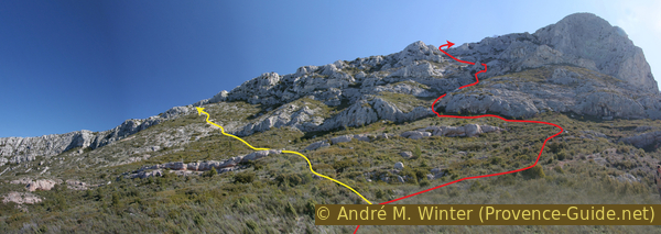
Costes Chaudes, Pas du Moine and Bau Cézanne
The diagonal yellow line to the left of the center of the picture is the path to the Pas de l'Escalette, our path over the Pas du Moine saddle is further to the right and red.
We then move in a wild rocky landscape. You pass a natural semi-cave and wonder where the path leads to. But there is a rock ramp that helps overcome this obstacle. Now the most difficult sections are behind us, the path meanders through rocks becoming flatter. Finally, we cross the ridge line at a large cairn, it marks the entrance to the Pas du Moine (1f) from above.
No reproduction is permitted without the written consent of the author. (id3290)
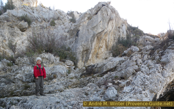
Our 8 year old son in the ramp at Pas du Moine
We are now on the main path to the monastery and the Croix de Provence (2b). The path is now marked in blue. Normally you will meet many other hikers here who have chosen the easier climb via the Sentier Imoucha. We will descend there later.
No reproduction is permitted without the written consent of the author. (id3291)
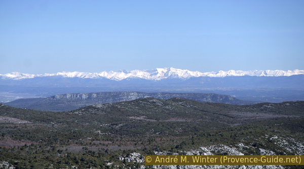
In spring there is still snow in the Alps
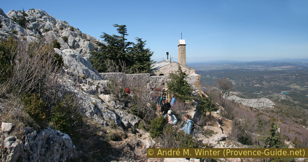
The further way is easy, the former small monastery and the cross are in sight. However, there are still around 200 vertical metres to go. The trail isn't as varied as the previous section and some will break a sweat here. After a third to the monastery, the path turns slightly away from the ridge. In winter, you come here in a permanently shady area, from here you definitely have to put on an extra layer of clothes.
A few minutes later, the GR9 long-distance hiking trail joins from the bottom right. Our marking changes and becomes white-red.
The small monastery and the big cross Croix de Provence
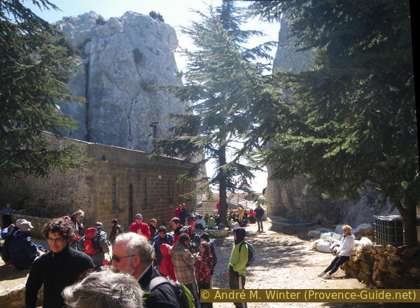
The way to the monastery is a real pilgrimage route, it was actually once and even today you are rarely alone here. At the top, you enter the area through a stone gate. Immediately to the left is the mostly closed chapel. In front of it is a large area made up by the former monks, old monastery buildings, a large tree and a cistern. The area stretches south to a kind of panoramic terrace with a stunning view of the south face, the ascent path and, theoretically, the sea.
The site is guarded and the chapel is open when the Provençal flag flies above. In season it is on Thursdays and Sundays depending on the availability of volunteers.
No reproduction is permitted without the written consent of the author. (id3292)
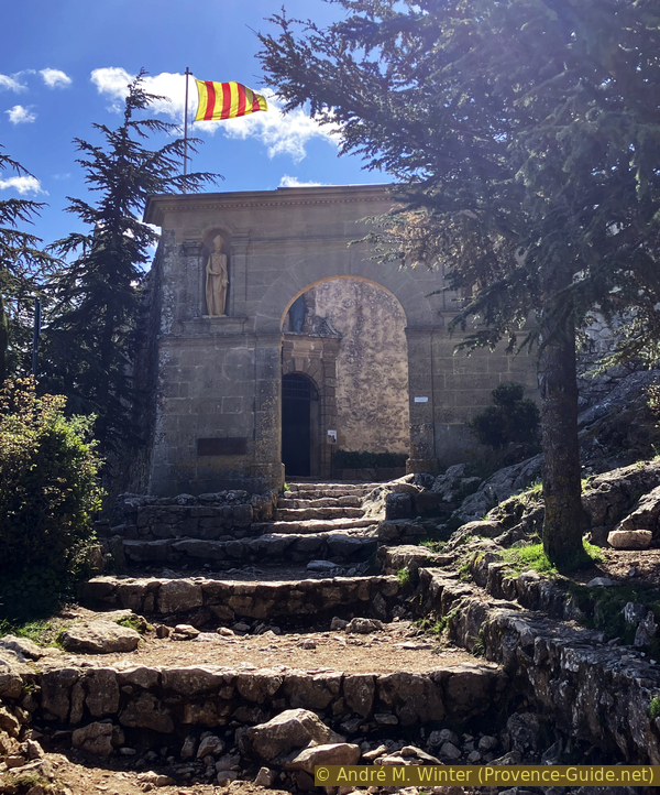
Archway to the chapel area
The area seems peaceful in the rugged limestone landscape. In winter, the large shelter is a welcome protection from the cold wind. The building has been renovated, you can sleep on the wide benches if you have mats andsleeping bags with you. The old fireplace has been relocated and given a taller chimney so you can heat (and barbecue) better, but you still have to bring your own wood. However, you should not believe that you can create cosy warmth with the open fire in the large stone house, good sleeping bags are recommended.
In winter, it is better to ascend from Vauvenargues if you want to take wood with you (see Montagne Sainte Victoire from the north). Here you climb through a dense forest and sometimes along the path of the Chemin des Venturiers (GR9) you can find cut logs that generous people put aside for the precise purpose of heating up in the shelter (especially around Christmas). But you can also find firewood in small nets to buy in most supermarkets in the region.
No reproduction is permitted without the written consent of the author. (id3293)
At the Notre Dame de la Victoire chapel
Section 2: Prieuré - Croix de Provence - Prieuré
➙ 0,6 km ... 15 min ➚ 40 m ➘ 40 m ↝ easy
100% moderate trails, with marks
The clues
- Out through the gate and immediately to the right
- Ascend to the cross
- Again down the same path to the chapel area
It's not far to the cross.
No reproduction is permitted without the written consent of the author. (id3294)
Notre Dame de la Victoire chapel seen from the way to the cross
Next to the entrance portal, a path continues outside under the wall. This path passes quickly on rocks to the east above the former monastery. Shortly before the cross there is a fork: on the left you could do the long-distance hiking trail GR9 over the entire ridge to the Pic des Mouches (the actual summit of the Montagne Sainte Victoire), on the right you are after a few minutes directly under the cross (and by closed shelter, as well as the ruin of a firefighter look out). The monumental 19 m high cross dates from 1875.
On the photo, the impressive cross is seen from the eastern secondary peak, but we are climbing from the other side.
Croix de Provence seen from the east
The markings are good, which usually shows that there are a lot of people walking here. On the way back, which we lay out more extensively, we also come through sections that are less frequented.
Marking under the Croix de Provence
Section 3: Costes Chaudes & Sentier Imoucha
➙ 4 km ... 1 h 15 min ➚ 30 m ➘ 490 m ↝ average
75% easy trails, with marks
25% easy trails, without marks
The clues
- Descend to the Pas du Moine saddle
- Continue down to the Pas de l'Escalette
- Over the ridge of the Costes Chaudes
- Continue along the Sentier Imoucha trail
- After the power line left
- Exit the Vallon de la Dispute
For the way back we look further west, with beautiful views back on the great mountain.
No reproduction is permitted without the written consent of the author. (id3295)
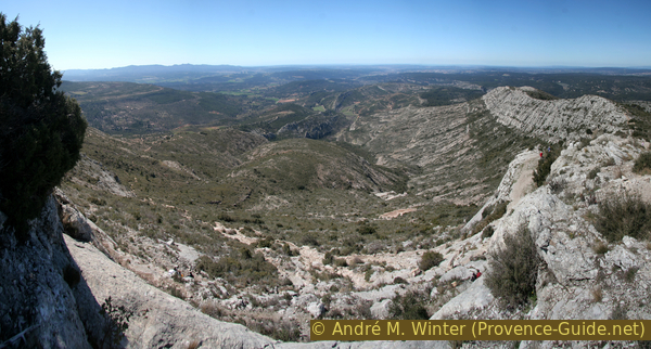
Crete du Marbre, Roques Hautes and Costes Chaudes
The path descends over the Costes Chaudes on the right and later through the smaller ridges in the center of the picture.
The descent is easy. Especially on hot days, the experienced hiker will have started early in the morning and will see the others panting when the sun is already high in the sky. We pass the Pas du Moine (3b) but continue along the ridge and follow the blue mark. A quarter of an hour later, we come to the Pas de l'Escalette (3c). This is an easier path that runs parallel to our ascent. You could shorten the tour here and descend to the starting point via the Refuge Cézanne. But we advise against it: firstly, you would miss interesting sections, especially the impressive views back on the mountain. Secondly, quite a lot of people walk on this trail in both directions. Among them are sometimes poorly equipped Sunday hikers, we've seen people with espadrilles here! So let's bypass this area...
No reproduction is permitted without the written consent of the author. (id3296)
We enjoy the view from the Costes Chaudes
sentier = trail
vallon = small valley
costes (côte) = prov. for rock bar
roques = (here) rocks
vers = to
arrêt = stop
crête = ridge
mas = prov. for farmhouse
The western ridge of the Montagne Sainte-Victoire, after the steep descent, continues over a less pronounced ridge of rock called Costes Chaudes. Our path runs directly on it, the cliffs are less abrupt, but you still have to be careful, because often two paths run parallel: the actual path to the right below the ridge line and variants to the left closer and more airy at the edge. You shouldn't forget to turn around every now and then, in the afternoon the sun should optimally set the scene for the Montagne Sainte-Victoire.
No reproduction is permitted without the written consent of the author. (id3297)
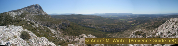
Montagne Sainte-Victoire, Barre du Cengle and Chaîne de l'Étoile
From higher up, the ridge of the Costes Chaudes looked flat, but on site we see that the descent continues. The water surface of the Lac du Bimont reservoir glitters at the bottom right. Especially in summer, it is tempting to descend to the cool water. The path Sentier Imoucha, which we are on here, would actually lead quite close to a side arm and to the dam. However, since the lake is artificial, it has very steep banks, the water level is variable and the valleys are narrow. This is not very inviting for bathing.
No reproduction is permitted without the written consent of the author. (id3298)
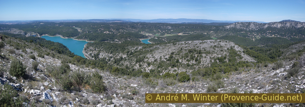
Lac du Bimont, Mont Ventoux and Massif du Concors
Our ridge gets lost in the loose forest of the garrigue. We come under a high-voltage power line (3d), that's an important clue! One can go left directly under the power cables in the Vallon de la Dispute valley, but the path may be overgrown. It is better to walk about 250 m further ahead left (3e) down an old forest road. The forest is lighter here, but there are no markings. The photo was taken on this trail below Sentier Imoucha.
No reproduction is permitted without the written consent of the author. (id3300)
Costes Chaudes and Montagne Sainte Victoire
In spring, irises with very short stalks shoot out of the ground.
No reproduction is permitted without the written consent of the author. (id3299)
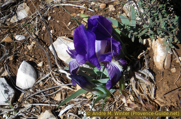
Iris lutescens
We descend along a forest road that seems to have been made to clear the undergrowth. Below we cross a dry valley and climb again slightly to get to another rocky edge. Here we can only go to the right. Everything that looks like a way in aerial photos are just nasty and steep gullies. It is better to continue west until you come to a forest road that crosses at an angle (4a) and turn left here.
Section 4: Roques Hautes - Refuge Cézanne - Parking
➙ 4,1 km ... 1 h 30 min ➚ 160 m ➘ 200 m ↝ easy
75% dirt roads, with marks
10% easy trails, with marks
10% easy trails, without marks
5% cross country
The clues
- Continue on the forest road
- A large loop can be abbreviated
- Bypass the Mas des Roques Hautes on the left
- After the rock breakthrough left
- Up the forest road, two hairpin bends can be shortened
- After the saddle, the Refuge Cézanne is in sight
- Back to the starting point on the ascent path
Return through lesser-known sections of the area.
No reproduction is permitted without the written consent of the author. (id3301)
Limestone ridges west of the Montagne Sainte-Victoire
We now follow this forest road, it leads us down to the south-east. Follow the markings and if they are not visible, rather take the paths on the left (4b). So you can cut a loop of the forest road. Our path leads back to it later. So we follow the valley floor down.
At Roques Hautes, when you see a farmhouse on the right in front, we come to an unusually flat and farmed level. When it was wet wetter, streams filled up these areas. Further ahead you can also see a beautiful gorge. Here the river has cut the ridge of the Crête du Marbre at a right angle.
No reproduction is permitted without the written consent of the author. (id3302)
Breakthrough in the ridge under the Mas des Roques Hautes
Access to the yard is obviously undesirable, so we shouldn't turn right. We have to go straight through to the breakthrough in the rock ledge. To do this, you first have to go slightly to the left (4c) to thread a narrow path between the field on the right and the rock on the left. We take the path to the breakthrough valley and then immediately turn left. From here it goes uphill again, the forest road lies between a rock face on the left and a small mostly dry stream and a greener ridge on the right (Harmelins). We have to go further up this valley until the road makes a bend (4e) to the right.
No reproduction is permitted without the written consent of the author. (id3303)
Mas des Roques Hautes
vers = to
arrêt = stop
pont = bridge
de = from
In the hairpin bend (4e) we go straight ahead on a less distinctive and unmarked path. It continues along under the rock face. After about 300 m, you come across the forest road (4f) again, we have cut off two big hairpin bends. It continues straight ahead in the same direction. Since the breakthrough it's been uphill, it's about 160 meters of counter ascent, which you can feel in your legs.
No reproduction is permitted without the written consent of the author. (id3304)
Spherical eroded limestone near Roques Hautes
Further on, the incline becomes less and slowly we return to familiar territory. We see the great mountain again from the perspective at the beginning of the tour and shortly afterwards we recognize the rocks at Refuge Cézanne. From here back to the starting point as on the ascent route.
No reproduction is permitted without the written consent of the author. (id3305)
Costes Chaudes and Roques Hautes
Sources and additional information
This walk is inspired by this website: Les Amis de Sainte-Victoire (Saint Victoire Friends Association, only french). All regular ascents around the mountain are described with good pictures.
It is better to use a good topographical hiking map: the tour is on the IGN map "Étang-de-Berre, Istes, Marignane, Martigues", scale 1:25000, 3244ET.
If you don't want to bother with a paper map, you can also use mapping apps on your cell phone. On the one hand, it is the Cartes IGN app from the official map service. However, it requires access to the data network and this is sometimes difficult in canyons or remote locations.
Alternatively, you can use apps that store data directly on the device. They're generally not free, but they don't cost much. We mainly use OSMAnd, here it is possible to add contour lines, relief shading, markings and others. To store this data on your phone you need a lot of space.
Of course, one needs access to satellites for the GPS signal with any app. In some canyons this is not the case. Therefore, do not rely on the position shown, but read the map on your phone as you would read it on paper. Most apps are available for Android and iPhone. The applications usually allow us to record the route travelled and also view the GPS files offered for each of our hikes.
This page has been seen 6346 times since 20 March 2024.
No reproduction is permitted without the written consent of the author. (id3306)
Looking back at the Montagne Sainte-Victoire