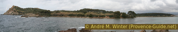
Petit Gaou and Grand Gaou islands
Small islands with a wild coast
walk
easy
1 h
yes
yes
yes
walk
Introduction
There are still free access treasures on the Côte d'Azur. The Islands of Petit Gaou and Grand Gaou are connected by bridges to the mainland, traffic is prohibited there. The site is well known to locals, people come here especially in the evening for the sunset. In winter, it plunges here into the sea. It is better to come on a windy day, a stormy sea makes the hike even more memorable.
The facts
4 km total distance
1 h walk time
30 m total elevation
orientation easy
mark 0% of the total distance
55% easy trails
45% hard-surfaced quiet side streets
dangers exposed rocky coasts
children yes
useful picnic stuff
required trekking boots, hiking equipment and water
GPS coordinates (WGS84) of start and end point 43.07465176950117,5.800176396431144
downloads ![]()
![]()
Public transport
The nearest train stations are Toulon TGV station and the La Seyne/Six Fours and Ollioules/Sanary regional train TER PACA (only french) stations. From these stations and in the direction of Cap Sicié, which stands out on the sea between Six-Fours-les-Plages and Seyne-sur-Mer, there is the Réseau Mistral (only french) transport network that covers the greater Toulon area. These bus lines allow you to get close to the starting point at the port of Le Brusc.
Line 87 makes it possible to come from Les Sablettes and from the centre of Six-Fours, here with around 20 connections per day. Get off at the stop Port dz Brusc and continue along the sea shore. You can also continue to the Le Brusc terminus, but in this case you cannot stop at the fishing boats that lie along the coast.
Access by car
The centre of Six-Fours is not clearly discernible. A major road crosses the town from the beaches of Six-Fours in the west to the town of La Seyne in the east. Several roundabouts are arranged here. The one to the west and lined with several palm trees allows you to reach the Brusc. Pass the Port de la Coudoulière and continue south. The road then passes behind various small capes before returning to the sea at Port du Brusc. Pass the small fishing port and take the Quai Saint Pierre car park which follows along the road.
No reproduction is permitted without the written consent of the author. (id6505)
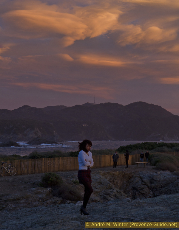
Wman in the cold wind on Petit Gaou
Useful parking spaces
The starting point is at the Quai Saint Pierre car park south of the fishing port of Le Brusc. You can also continue to Le Brusc where there is another car park, but in this case you cannot stop at the colourful fisher boats attached along the coast. All car parks are chargeable during the summer season.
Hints
It's the ideal walk at the end of a holiday or weekend to take a breath of fresh air.
Access to Île du Grand Gaou is only possible between 8 and 20h, sometimes a little longer in summer. Le Petit Gaou has not such limits.
There are also a few beaches on the Ile du Grand Gaou. In the southern part there are rocks and coves where you can observe the marine life well with mask and snorkel.
The photos of this page were taken during different visits between 2010 and 2021, but always in winter and in strong winds.
The whole region is a zone with a high risk of forest fires. In summer, but also in other seasons when it is very dry or by strong winds, access to the forest areas can be regulated. As a result, the roads may be closed to traffic and/or the trails prohibited to hikers. Current information: Map of access to the forests of the Var (also english). The map shows the colours green, yellow, orange and red which correspond to levels of danger.
The sections
- From Port de Brusc to the island of Petit Gaou.
- Loop around Grand Gaou Island and back to the starting point.
Section 1: Petit Gaou
➙ 1,4 km ... 25 min ➚ 10 m ➘ 10 m ↝ easy
55% hard-surfaced quiet side streets, without marks
10% easy trails, without marks
5% hard-surfaced quiet side streets, without marks
30% easy trails, without marks
The clues
- Quai Saint Pierre car park, 2 m
- Venus emerging from the Flots, 7 m
- Bridge between the two islands, 2 m
The outward walk to the islands and around the Île du Petit Gaou.
Continuing south of Port du Brusc, you pass the Six-Fours-les-Plages Yacht Club and then really begins the Corniche Des Îles. We see the Îles des Embiez opposite and the more we turn with the road also the Grand Gaou island.
Late at night, of course, you see only dark silhouettes.
No reproduction is permitted without the written consent of the author. (id6496)
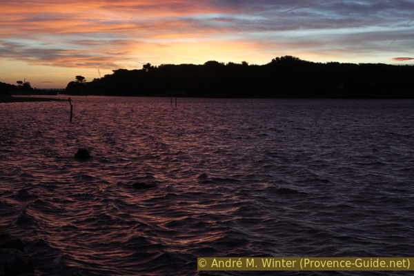
Rade du Brusc after sunset
Directly at the edge of the road, protected in the Rade du Brusc, are attached several very colorful small boats called pointus. These small fishing vessels have historical sites as for example also in Fabrégas bay.
However, we continue to walk in a straight line. We pass the large, often full car park and the terminus of the bus line. We can now continue in a straight line or along the sea. Further on follows a bridge which brings us to the Petit Gaou island. We pass to the left of a last restaurant building, we pass a barrier and now we are on the small island.
No reproduction is permitted without the written consent of the author. (id6489)
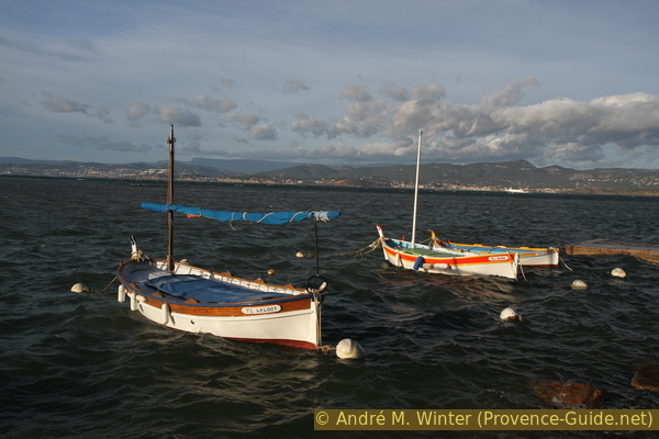
Fisher boats along road Corniche des Îles Paul Ricard
The advantage of spending the evening here is to have the best view of the rather wild coast of Cap Sicié. You can also see the Notre-Dame de Mai chapel and the transmitter antenna from here. We can pass it on the tour of Cap Sicié whose starting point is identical to the one of this tour.
No reproduction is permitted without the written consent of the author. (id6490)
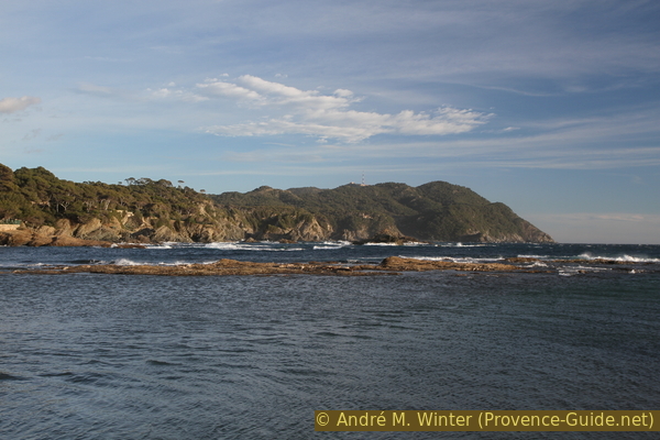
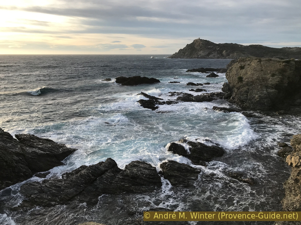
Cap Sicié south coast as seen from Petit Gaou island
This statue by the Swiss-born artist Robert Forrer was inaugurated in 1961. His gaze turned towards Le Brusc, which is logical, since it is Venus emerging from the waves.
The statue suffers from erosion like the rocks of the coast.
No reproduction is permitted without the written consent of the author. (id6495)
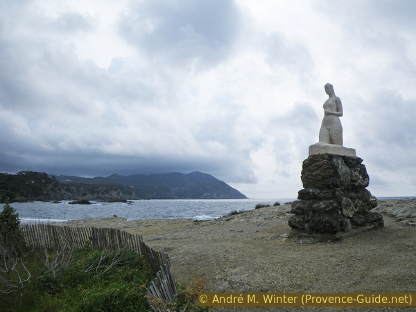
Vénus sortant des Flots
The south coast of these islands is jagged by erosion. It does not rise many meters, but this height is enough to shelter from most waves. This place is the most interesting when there is a strong east wind in winter.
No reproduction is permitted without the written consent of the author. (id6494)
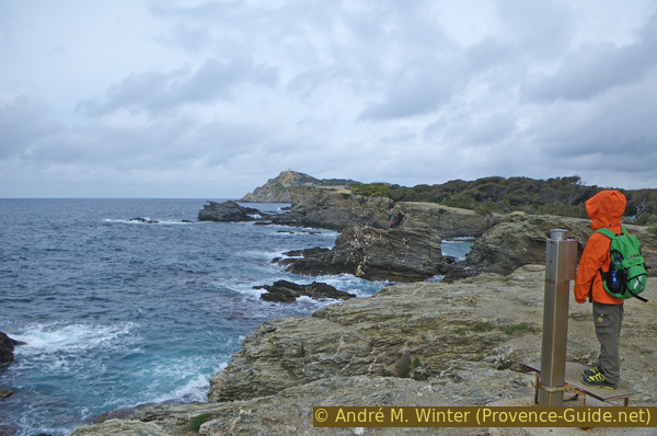
Petit Gaou island south coast and Île des Embiez behind
The small island is covered with bushes in the centre. On its edge, several small points allow you to move forward to see the coast from different angles.
We quickly went around this first island, so let's go over the footbridge to see the other one, which is actually bigger.
No reproduction is permitted without the written consent of the author. (id6491)
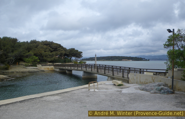
Pedestrian bridge between Goau islands
Section 2: Grand Gaou
➙ 2,7 km ... 40 min ➚ 15 m ➘ 15 m ↝ easy
60% easy trails, without marks
40% hard-surfaced quiet side streets, without marks
The clues
- Bridge between the two islands, 2 m
- South coast
- Détroit du Grand Gaou, 0 m
- Bridge between the two islands, 2 m
- North coast
- Quai Saint Pierre car park, 2 m
We go around the big island and return to the starting point.
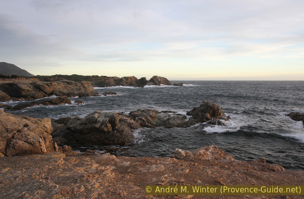
The south coast of Île du Grand Gaou is similar to that of Île du Petit Baou. The capes are a little higher and of course the island is about four times larger. That still doesn't make it a big island.
There are toilets on the island, they are indicated on the map at the top of the page. However, they are closed out of season.
Turn left after the bridge to reach the south coast.
No reproduction is permitted without the written consent of the author. (id6497)
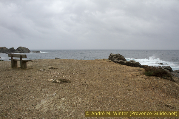
Bench with a view
We now see a little better on the tower on the Island of Embiez. This island is not accessible by a footbridge, although the strait is really not wide.
No reproduction is permitted without the written consent of the author. (id6499)
View from Grand Gaou to Île des Embiez island
On the first cape in the south of Grand Gaou, you can see both sides: the Island of Embiez and Cap Sicié.
No reproduction is permitted without the written consent of the author. (id6500)
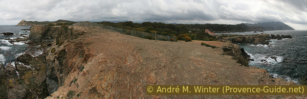
Grand Gaou island panorama
Looking back towards Petit Baou, we see that these islands are very flat.
No reproduction is permitted without the written consent of the author. (id6498)
View from Grand Gaou to Petit Gaou
The famous strait Détroit du Grand Gaou is a shallow ford.
There is no bridge to the Îles des Embiez because they were bought in 1958 by Paul Ricard, the pastis baron. It is today a touristic used island with hotels and a large port.
No reproduction is permitted without the written consent of the author. (id6501)
Détroit du Grand Gaou
Embiez means "the combination of both". It is formed by the meeting of the islands of Tour Fondue and Saint-Pierre, initially linked by a bank of alluvium as seen in the Rade du Brusc. Between these two islands were salt marshes, from 1960 the marina was dug there.
No reproduction is permitted without the written consent of the author. (id6502)
Île des Embiez island
The northern part of the island is much flatter and wooded. The path borders a rectangular area devoid of vegetation in the centre. It seems that there were military installations here during the Second World War.
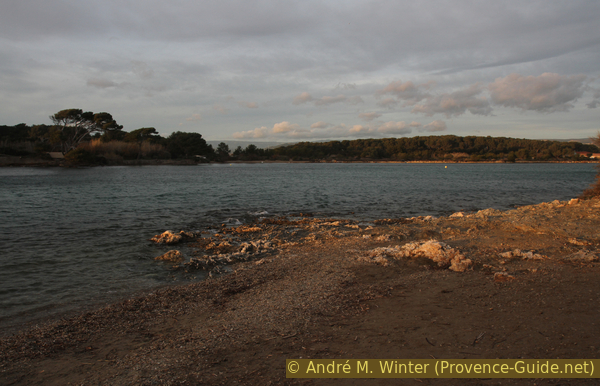
Our path stays a little behind the coast. When we reach it, we see that the entire northern part is a long beach overlooking the very shallow Rade du Brusc.
To the north shines the coast of Sanary and the limestone mountain ranges of the Toulon area.
No reproduction is permitted without the written consent of the author. (id6503)
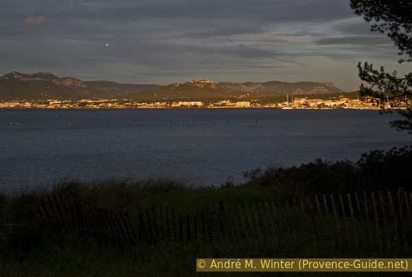
View on Sanary
When you are here in the evening, it is of course a good idea to return to the south coast of Petit Gaou for the sunset. Otherwise, continue straight after the bridge, pass to the left of the restaurant building and return to the starting point in about ten minutes.
No reproduction is permitted without the written consent of the author. (id6492)
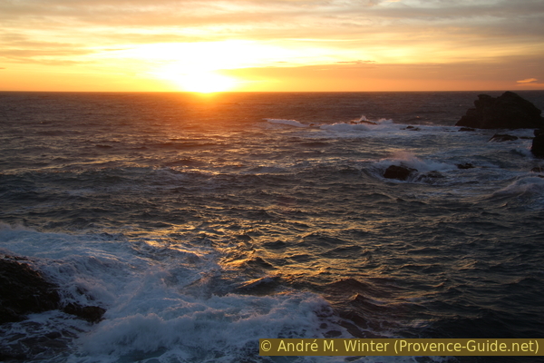
Winter sunset on Petit Gaou island
Sources and additional information
It is better to use a good topographic hiking map: the tour is on the IGN map "Toulon, Le Gros-Cerveau, Mont-Faron", scale 1:25000, 3346OT.
If you don't want to bother with a paper map, you can also use mapping apps on your cell phone. On the one hand, it is the Cartes IGN app from the official map service. However, it requires access to the data network and this is sometimes difficult in canyons or remote locations.
Alternatively, you can use apps that store data directly on the device. They're generally not free, but they don't cost much. We mainly use OSMAnd, here it is possible to add contour lines, relief shading, markings and others. To store this data on your phone you need a lot of space.
Of course, one needs access to satellites for the GPS signal with any app. In some canyons this is not the case. Therefore, do not rely on the position shown, but read the map on your phone as you would read it on paper. Most apps are available for Android and iPhone. The applications usually allow us to record the route travelled and also view the GPS files offered for each of our hikes.
This page has been seen 2989 times since 20 March 2024.
No reproduction is permitted without the written consent of the author. (id6504)
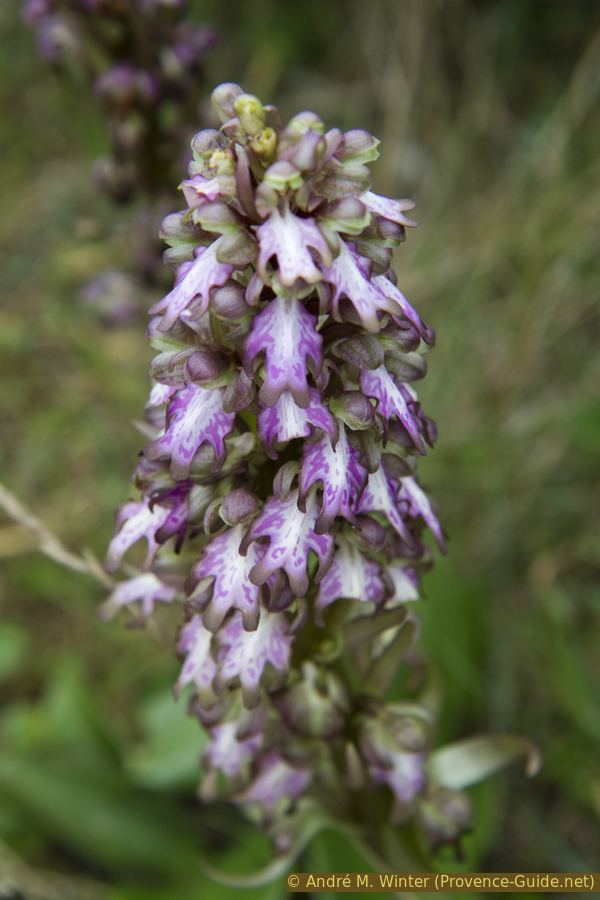
Himantoglossum robertianum in january