Sirenian fossils at Col des Lèques
Short hike to fossils let in place
walk
easy
1 h 15 min
no
no
no
walk
Introduction
Here you can go see 35 million year old fossils that have not been transferred to museums. Those were left on site as petrified bones of the ancestors of the current sea cows. We are here at 1200 meters above sea level as the Alpine uplift still persists today.
The facts
4,1 km total distance
1 h 15 min walk time
140 m total elevation
orientation easy
mark 100% of the total distance
70% easy trails
20% forest roads
15% dirt roads
dangers ice in winter
children yes
useful picnic stuff
required trekking boots, hiking equipment and water
GPS coordinates (WGS84) of start and end point 43.865694,6.464246
downloads ![]()
![]()
Public transport
The express bus line 51 if Zou! (only french) runs twice a day between Nice and Grenoble and therefore also between Castellane and Senez. Between these two lays the Col des Lèques saddle, but there is no stop. You can ask the driver to be dropped off there, but that does not exempt you from having to deal with the return because it will not be possible to stop a bus passing. Apart from this possibility, there are only taxis from Castellane (15 minutes and 10 kilometres).
Access by car
We are on one of the important passes of the Route Napoléon, more specifically between Castellane and Digne-les-Bains. The road is called D4085 until Barrême and N85 until Digne.
Useful parking spaces
Directly at the pass is a free car park with approximately 25 spaces, a dozen other spaces are located along the road. It is right next to a campsite.
Hints
It's a short hike that you can also do on the drive-through these parts of the Alps.
Loops are possible, but they are all necessarily much longer than this walk there and back.
The whole region is a zone with a high risk of forest fires. In summer, but also in other seasons when it is very dry or by strong winds, access to the forest areas can be regulated. As a result, the roads may be closed to traffic and/or the trails prohibited to hikers. Current information: Access map to the forests of Alpes de Haute Provence (also english). The map shows the colours green, yellow, orange and red which correspond to levels of danger. The affected area is: Préalpes de Digne.
No reproduction is permitted without the written consent of the author. (id6348)
Protected fossils
The sections
- Way up from the saddle to the fossils under La Grau mountain.
- Back on the same way.
Section 1: Col des Lèques - Siréniens
➙ 2 km ... 40 min ➚ 95 m ➘ 45 m ↝ easy
15% dirt roads, few marks
20% easy trails, few marks
20% forest roads, with marks
50% easy trails, with marks
The clues
- Col des Lèques saddle, 1150 m
- Prés des Lèques meadows, 1140 m
- fossil site, 1200 m
A way up over alpine meadows and crossing a few ravines.
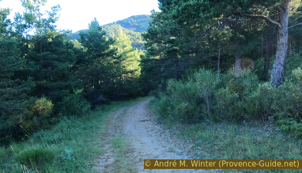
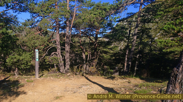
At the departure car park there are explanatory panels for hikes, including this one. We start on the dirt road in a north-east direction, we are guided by fences on both sides.
No reproduction is permitted without the written consent of the author. (id6322)
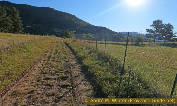
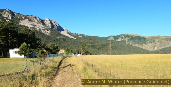
Farm track north of Col des Lèques saddle
We normally stay on this track traced by tractor wheels to descend into a hollow above the houses of Haute Sionne. Out of season and when the left fence is folded down, you can however pass on a path on the meadow on the left. This avoids losing altitude. We follow the forest on the left, then we continue straight to come back on the marked path.
No reproduction is permitted without the written consent of the author. (id6323)
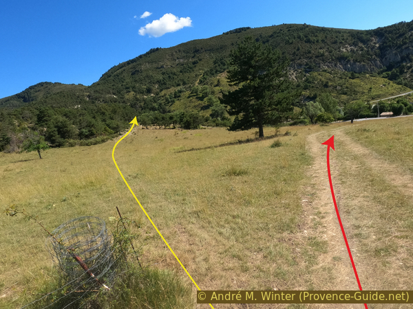
Junction north of the Col des Lèques saddle
Looking back, you can see Cadières de Brandis mountain. This is the other doable tour from the pass.
No reproduction is permitted without the written consent of the author. (id6329)
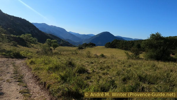
Meadows at Col des Lèques and Cadières de Brandis mountain
View south while we are walking north-west.
However, we continue to climb the long meadow. Either on the track of the tractors, or on the path in the hollow.
No reproduction is permitted without the written consent of the author. (id6330)
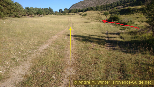
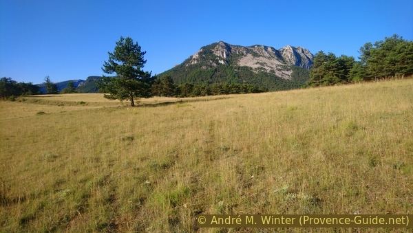
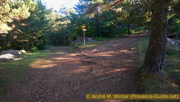
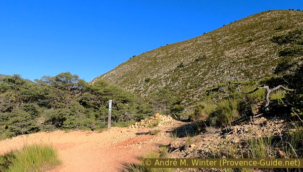
Tracks on Pré des Lèques meadows
Arrived at the top of the meadow, we cross various agricultural tracks. We do not change direction and we enter the forest. Here we come to a signpost. We continue straight ahead.
On the right, we arrive in an hour at the rocky bar called Sommet de Fumée (smoke summit). A curious name for a mountain in an area prone to forest fires.
No reproduction is permitted without the written consent of the author. (id6331)
Junction La Fondue
We pass a lonesome ruin.
No reproduction is permitted without the written consent of the author. (id6332)
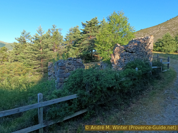
Ruin near La Fondue
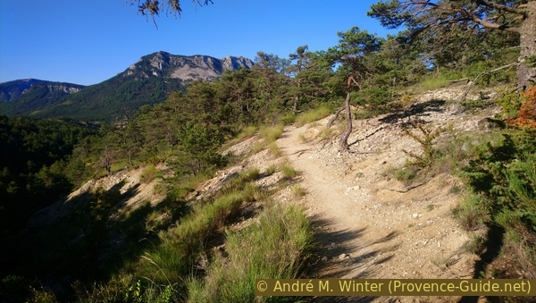
At times, you can see straight ahead on La Grau mountain. In the ravine at the foot of it are located the fossils.
No reproduction is permitted without the written consent of the author. (id6333)
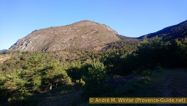
La Grau mountain
We enter a wooded cirque crossed by several ravines that we have to cross. The forest track gets narrower and narrower, it turns into a simple path further ahead.
No reproduction is permitted without the written consent of the author. (id6334)
Way to the fossils
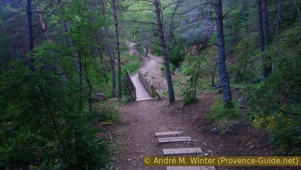
At each ravine, the path descends and then ascends. The two main ravines are laid out with steps and a pedestrian bridge at the bottom.
No reproduction is permitted without the written consent of the author. (id6335)
Footbridge over Ravin de Reissacier
Leaving the last ravine, we arrive at a free area without vegetation.
No reproduction is permitted without the written consent of the author. (id6336)
Our track after two ravines
We arrive at a ridge where we turn down left. The fossils are straight ahead, but the slope is too steep. It is bypassed by the left and the bottom.
No reproduction is permitted without the written consent of the author. (id6337)
Left on this last ridge
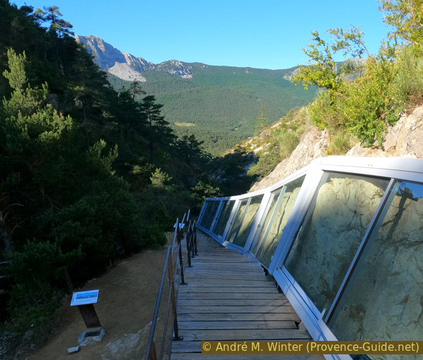
We cross the ridge at halfway and enter the last ravine under La Grau mountain, called Ravin de Tabori. We see the fossils protected by glass during the descent.
No reproduction is permitted without the written consent of the author. (id6338)
Turn right on the ridge
Arriving in the valley, we cross it and turn left. The Ravin de Tabori watercourse has unearthed two very different juxtaposed limestone layers at this location.
There is sometimes water in the ravine below. On the right bank, there is massive grey Jurassic limestone, 145 million years old. On the left bank the marls and yellowish sandy limestone are 35 million years old. Between the times these two strata were deposited, 110 million years elapsed, in which there remain no rock formations. This gap is due to an erosional phase resulting from the first regional folds: the Jurassic limestone was left bare and valleys were dug into it. Some 35 million years ago, the sea came back and the valleys were immersed. At this point, there was a cove at the bottom of which mud and sand deposited to form the yellowish rocks containing the fossil sirenias. These can now be found further below on the other side of the bank.
No reproduction is permitted without the written consent of the author. (id6339)
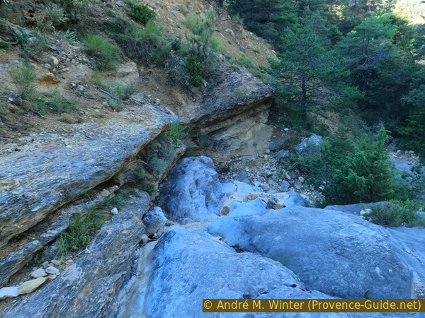
Fossil shore between Eocene and Upper Jurassic
We see the protected fossil area in front of us. It is advisable to go down first on the left towards the explanatory panels, then to go up along the glass panels.
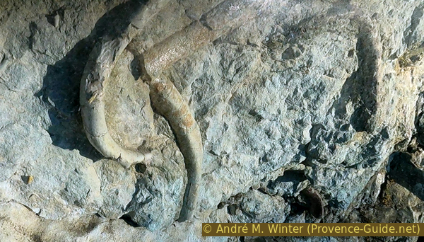
Sirenians are marine mammals also known as sea cows, since they ore herbiyarous. They live in warm coastal regions and feed on algae and other aquatic plants. The bones here belong to the Halitherium toulonense species, a very ancient relative of today's dugongs and manatees. This is one of the oldest sites with sirenian remains and it is unique for the large number of well-preserved fossils.
No reproduction is permitted without the written consent of the author. (id6341)
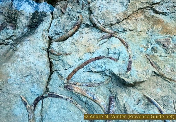
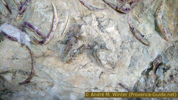
Eocene manatee ribs
As in most sirenia deposits, the ribs and vertebrae are the most abundant. The presence of other parts of the skeletons makes the site interesting. Among the most seldom pieces: four skulls, a lower jaw, a forelimb with the bones of the arm, forearm and hand. For such remains to be preserved, the corpses had to be very quickly buried in the sediment. The sudden arrivals of sand and mud in the creek can be the result of storms.
No reproduction is permitted without the written consent of the author. (id6340)

Replica of the valley with manatees from the Eocene by B. Nicolas
The number of fossils is diversified during the Eocene (56 to 34 million years). These animals lived where marine plants abound, so near the coast, along rivers and estuaries. Towards the end of the Eocene, more Dugong-like types of sirenians appeared, their front legs having become flippers and the tail transformed into a horizontal caudal fin. As with cetaceans, the movements were made by undulation from top to bottom.
No reproduction is permitted without the written consent of the author. (id6342)
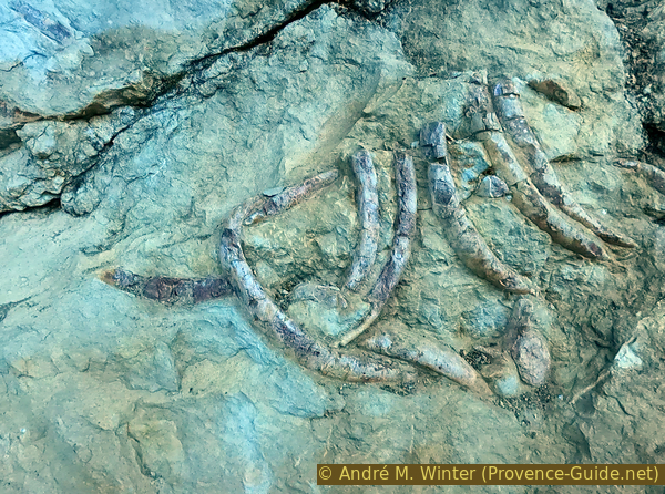
Sirenian rib cage
It takes a long time to recognize the different parts of the animals. They are not as well-preserved as the Ichthyosaur of La Robine north of Digne-les-Bains.
No reproduction is permitted without the written consent of the author. (id6344)
Eocene manatee ribs
We return to the starting point on the same way.
No reproduction is permitted without the written consent of the author. (id6345)
Eocene manatee ribs and jawbone
Section 2: Siréniens - Col des Lèques
➙ 2 km ... 35 min ➚ 45 m ➘ 95 m ↝ easy
50% easy trails, with marks
20% forest roads, with marks
20% easy trails, few marks
15% dirt roads, few marks
The clues
- fossil site, 1200 m
- meadows Prés des Lèques, 1140 m
- Col des Lèques saddle, 1150 m
Return by the same route.
We therefore go up towards the ravine, pass the ridge and the forest with the two footbridges. We come back to the full sun on the meadows which bring us back to the parking lot.
No reproduction is permitted without the written consent of the author. (id6346)
Pré des Lèques while walking back
Sources and additional information
It is better to use a good topographic hiking map: this tour is on the IGN map "Castellane, Lac de Castillon", scale 1:25000, 3542OT.
If you don't want to bother with a paper map, you can also use mapping apps on your cell phone. On the one hand, it is the Cartes IGN app from the official map service. However, it requires access to the data network and this is sometimes difficult in canyons or remote locations.
Alternatively, you can use apps that store data directly on the device. They're generally not free, but they don't cost much. We mainly use OSMAnd, here it is possible to add contour lines, relief shading, markings and others. To store this data on your phone you need a lot of space.
Of course, one needs access to satellites for the GPS signal with any app. In some canyons this is not the case. Therefore, do not rely on the position shown, but read the map on your phone as you would read it on paper. Most apps are available for Android and iPhone. The applications usually allow us to record the route travelled and also view the GPS files offered for each of our hikes.
This page has been seen 2126 times since 20 March 2024.
No reproduction is permitted without the written consent of the author. (id6347)
Back on Col des Lèques saddle