The Ichthyosaur of La Robine
Path to preserved fossil at location
walk
easy
1 h
no
no
no
walk
Introduction
The fossil record of the La Robine Ichthyosaurus is unique. The skeleton is almost complete and was left where it was found. It is part of the Réserve naturelle géologique de Haute-Provence (protected area for nature and geology), which comprises several sites. The protected area is the largest of its kind in Europe and is also one of the UNESCO Geoparks.
Ichthyosaurs were marine vertebrates that looked similar to current dolphins, and like them, they had to come to the surface to breathe. They were present on Earth for 150 million years but disappeared 39 million years ago for no clear reason.
In contrast to fossils of shellfish, which are very common (see ammonites etc.), complete fossils of marine predators are very rare. This is because in the sea an animal cannot fall into a clay pit like a land dinosaur. When these animals die, they are torn apart by others and the ocean currents scatter the pieces over long distances.
The facts
4 km total distance
1 h walk time
190 m total elevation
orientation
mark 100% of the total distance
100% easy trails
dangers
children
useful
required
GPS coordinates (WGS84) of start and end point 44.171298,6.25042
downloads ![]()
![]()
Public transport
You cannot reach the starting point publicly. It is located around 10 km north of Digne-les-Bains.
Access by car
Digne-les-Bains is located in a valley east of the Durance, the central town is well signposted from all directions. In the city, keep east of the bed of the Bléone and later the Bès. Leaving the town on the D900A road, you pass the junction for the village of La Robine, cross a bridge, go through a wider stretch of valley with a few houses and just a kilometre further on we come to the Ravin de Bélier car park. It is on the left just below the road.
On the approach from Digne, you can also stop at the Ammonite slab at Digne-les-Bains.
Useful parking spaces
The Ravin de Bélier car park has been specially designed for access to the Ichthyosaurus site.
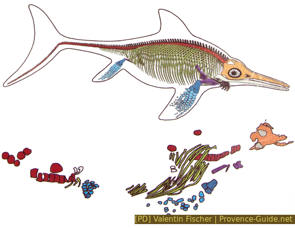
Comparison between reconstruction and find
No reproduction is permitted without the written consent of the author. (id4581)
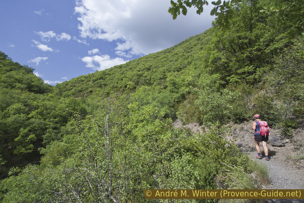
Ascent in the Vallon de St.-Vincent
Hints
Looking at a map, you might think it would be quicker and easier to get on via the southern valley. However, this is not desirable. It is private property and there is no parking. For this reason, you can not do a round trip.
The fossil find is protected by a small house and you can look inside through a large pane of glass. By sunshine, however, there are strong reflections. That's why the tour is also ideal when the sky is overcast.
The whole region is a zone with a high risk of forest fires. In summer, but also in other seasons when it is very dry or by strong winds, access to the forest areas can be regulated. As a result, the roads may be closed to traffic and/or the trails prohibited to hikers. Current information: Access map to the forests of Alpes de Haute Provence (also english). The map shows the colours green, yellow, orange and red which correspond to levels of danger. The affected area is: Préalpes de Digne.
The sections
- Ascent through the Ravin de Bélier valley and over the Col du Jas saddle, short descent to the site
- Back on the same way
Section 1: Parking - Ichthyosaure de la Robine
➙ 2 km ... 35 min ➚ 150 m ➘ 40 m ↝ easy
100% easy trails, with marks
The clues
- Ravin de Bélier car park, 710 m
- Col du Jas saddle, 840 m
- Excavation Site de l'ichthyosaure, 820 m
Ascent through a quiet valley and partly in the shade of a forest.
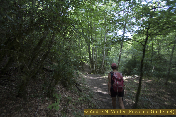
At the back of the parking lot are boards with maps of the location. The path leads behind it into the valley. You walk along a small creek. However, quite soon we climb up the south-facing slope. Some sections are hand-railed.
No reproduction is permitted without the written consent of the author. (id4580)
Ascent on the path in the Vallon de St.-Vincent
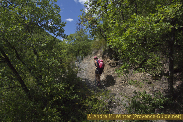
After a double hairpin bend, it becomes flatter and shady again, there is a bench here. But then it goes back up the sunny slope.
We cross the creek on a wooden bridge.
No reproduction is permitted without the written consent of the author. (id4582)
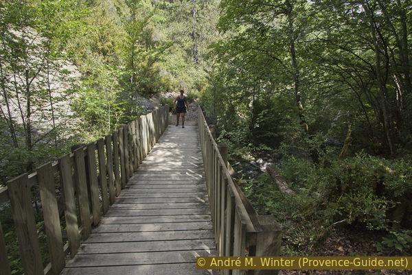
Footbridge over the creek in the St-Vincent valley
After changing to the other bank, we go in a higher and shadier forest. On this side, we also go up in hairpin bends to the Col du Jas saddle.
No reproduction is permitted without the written consent of the author. (id4583)
Dark north-facing forest
col = saddle
crête = ridge
On the other side of the ridge line, the vegetation is sparser again and we turn left. The terrain goes slightly downhill, our path leads to the south-east. On the right, you can see heavily eroded and bare dark marl, called Robine in France.
No reproduction is permitted without the written consent of the author. (id4584)
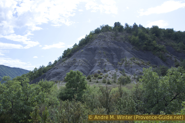
Erosion in the Serre de Clastre marl
The path is a bit wider in the valley floor, a small signpost points us to the left. The path on the right will be our way back.
Here we are on a small circuit that takes us to a good view of the Bès valley. Here you only see wooded slopes, no houses and no roads. The situation and the new design of the fossil site are explained on a board. All panels are exclusively in French.
No reproduction is permitted without the written consent of the author. (id4585)
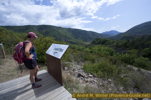
Information board and view of the Bès valley
After the board, the path makes a turn to the lower level and you finally get to the ichthyosaur site. A wooden terrace is in front of the house, which protects the fossils. However, there is no shelter against rain, hardly any shade and no water.
The panels explain: the location in the prehistoric process, the reason for the good condition of the find, the other fossils that can be found here and more detailed information on the Ichthyosaurus.
No reproduction is permitted without the written consent of the author. (id4586)
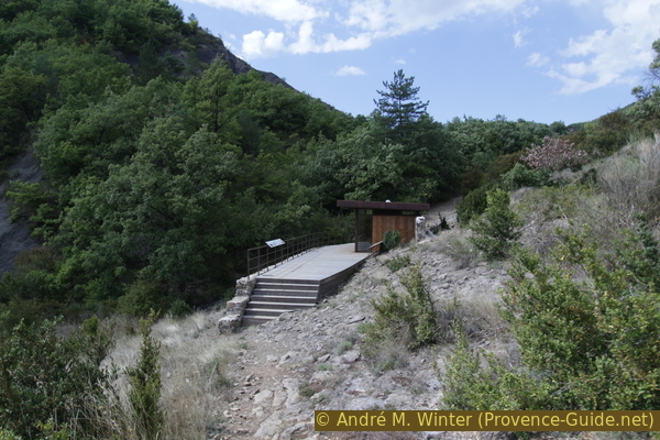
Establishment of the Ichthyosaurus fossil
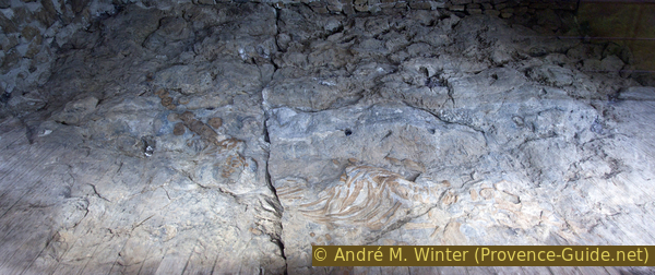
You can see the fossil find through a pane. The different colours are naturally caused by bacteria.
Next to the original in the ground there is a model of the find, here you can see the parts of the animal better.
No reproduction is permitted without the written consent of the author. (id4589)
Ichthyosaurus fossil
Section 2: Ichthyosaure - Parking
➙ 2 km ... 25 min ➚ 40 m ➘ 150 m ↝ easy
100% easy trails, with marks
The clues
- Excavation Site de l'ichthyosaure, 820 m
- Col du Jas saddle, 840 m
- Ravin de Bélier car parc, 710 m
Back over the saddle.
After the visit, we climb back up to the Col du Jas via the other end of the terrace and thus return to the parking lot on the same way.
Sources and additional information
It is better to have a good topographic hiking map: this tour is on the IGN map "Digne-les-Bains, la Javie, Vallée de la Bléone", scale 1:25000, 3440ET.
If you don't want to bother with a paper map, you can also use mapping apps on your cell phone. On the one hand, it is the Cartes IGN app from the official map service. However, it requires access to the data network and this is sometimes difficult in canyons or remote locations.
Alternatively, you can use apps that store data directly on the device. They're generally not free, but they don't cost much. We mainly use OSMAnd, here it is possible to add contour lines, relief shading, markings and others. To store this data on your phone you need a lot of space.
Of course, one needs access to satellites for the GPS signal with any app. In some canyons this is not the case. Therefore, do not rely on the position shown, but read the map on your phone as you would read it on paper. Most apps are available for Android and iPhone. The applications usually allow us to record the route travelled and also view the GPS files offered for each of our hikes.
This page has been seen 2321 times since 20 March 2024.