The Cabrone troglodyte dwellings by mountain bike
A short but very rough forest road with short steep sections
MTB tour
easy
30 min
no
no
shelter
5 % of the distance
Introduction
This is undoubtedly one of the shortest mountain bike tours. It's entirely on a forest track, but it presents some challenges that are jarring in the saddle. We could of course also go there on foot. We are aiming for an installation of an entire farm under several wide caves. The place is unique in its kind in the Luberon and in Provence.
The MTB rating gives the blue (easy) category because of the short duration. In reality it is rather difficult in certain passages.
The facts
2,5 km total distance
30 min movement time. incl. 10 min leave the bike and explore on foot
80 m total elevation
orientation easy
mark 0% of the total distance
65% forest roads
15% coarse gravel
15% difficult trails
5% easy trails
<5% hard-surfaced quiet side streets
dangers falling on difficult track
children no
useful picnic stuff
required Hardtail mountain bike and water
GPS coordinates (WGS84) of start and end point 43.956108,5.453171
downloads ![]()
![]()
Public transport
The starting point is not reachable by public transport. The regularly accessible point by bus is Apt, see timetables at Zou! (only french). From there by bike, it's at least 14 kilometres north on the D22 and D35 roads and 500 meters of elevation gain uphill.
Access by car
Coming from Marseille and the south-east (Var and Alpes-Maritimes), we reach Aix-en-Provence and continue towards Gap on the N296 road and the A51 motorway. Leave the motorway at the Pertuis exit, continue towards Pertuis, then take towards Cadenet at the following roundabouts and intersections. Reach the center of Cadenet and continue the signs towards Apt. In the town of Apt towards Sault. Later turn left towards La Garde d'Apt.
From Vaucluse and the western part of Bouches-du-Rhône, aim for Apt or Saint-Saturnin-lès-Apt then continue towards Rustrel. Then turn left towards La Garde d'Apt.
From Manosque, join Apt, but take towards Rustrel before. Later turn left towards La Garde d'Apt.
From the three previous departures, the road climbs in bends towards the Plateau d'Albion. Just after a particularly tight hairpin bend to the right, we spot a free space on the left.
From the upper Durance valley, take the Vallée du Jabron south of Sisteron towards Séderon. At the Col de la Pigère saddle, turn left towards Revest-du-Bion, then St. Christol, then Garde d'Apt. We descend the southern slope of the Plateau d'Albion. The road only begins to descend very slowly. Six minutes after La Garde d'Apt, we pass a final hairpin bend, then we follow the slope towards the west. Shortly after, there follows an open space on the right with a concrete track just behind.
Useful parking spaces
We park in the clear space to the right of the concrete track going uphill. There are also one or two places opposite going downhill along the split forest track.
No reproduction is permitted without the written consent of the author. (id7365)
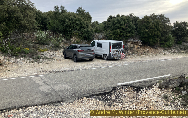
Parking on the D34 between Villars and Garde d’Apt
Hints
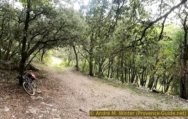
As mentioned above, the tour is very short. The forest track to follow is very changeable: concrete part, very large stones, exposed rock, sections washed out by rain, mud after storms. We climb in less than 10 minutes, but we think we have done much more.
It is of course possible to extend the tour via the multiple tracks that run along this southern slope of the Albion Plateau. We could thus start from lower (for example at La Fumeirasse) or go much higher (for example at Les Estfourniaux). The path which continues from Bergerie Cabrone towards the west is impassable for mountain bikes.
The whole region is a zone with a high risk of forest fires. In summer, but also in other seasons when it is very dry or by strong winds, access to the forest areas can be regulated. As a result, the roads may be closed to traffic and/or the trails prohibited to hikers. Current information: Map for access to the forests of the Vaucluse department (only french). The map shows the colours green, yellow, orange and red which correspond to levels of danger.
The sections
- Forest track upwards.
- Pause at Bergerie Cabrone.
- The same forest track down again.
No reproduction is permitted without the written consent of the author. (id7366)
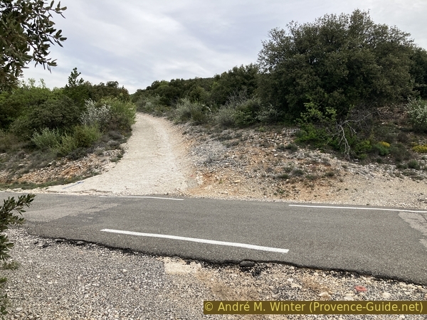
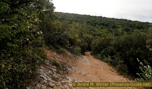
Departure of the track towards Bergerie Cabrone
Section 1: D34 - Bergerie Cabrone
➙ 1,2 km ... 10 min ➚ 62 m ➘ 10 m ↝ easy
↙ Colours of the sections like MTB rating but without the duration.
<5% hard-surfaced quiet side streets, without marks
15% coarse gravel, without marks
↖ very steep passages
25% forest roads, without marks
15% difficult trails, without marks
↖ very steep passages
45% forest roads, without marks
The clues
- Car park along D34 road, 750 m
- Ravin des Seysses, 810 m
- Bergerie Cabrone, 800 m
This is the climb, stay at the first two forks on the left and the third on the right. We always stay on a motorable forest road, but it is not suitable for a normal car.
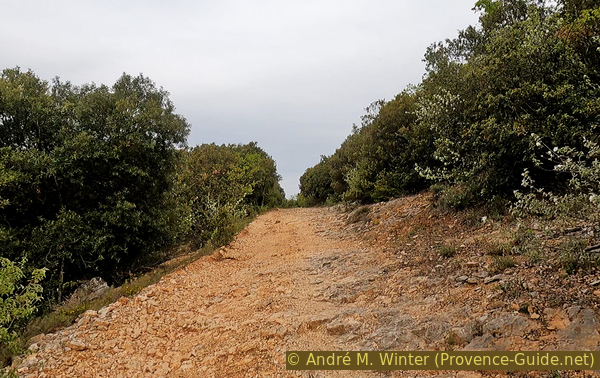
We climb the concrete ramp to the left of the small parking lot. The concrete may be covered with rubble. This easy cover doesn't last long.
The follwomg is as steep, but the road is made up of stones the size of tennis balls. The MTB tires grip well, but overall it is very bumpy.
No reproduction is permitted without the written consent of the author. (id7367)
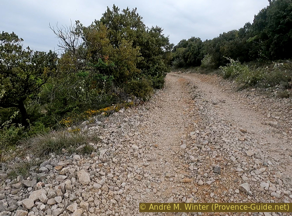
Track towards the Cabrone Bergerie with large stones
Before sweating seriously, we see a cabin on the left under the road. It is not a borie but a circular construction with mortar. It was a shepherd's or hunter's shelter. The roof is completely missing.
No reproduction is permitted without the written consent of the author. (id7368)
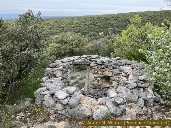
Stone hut with collapsed roof
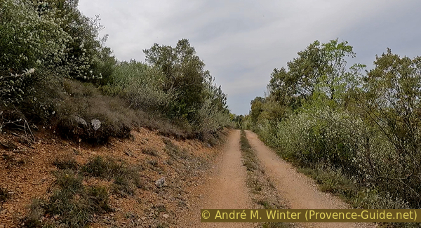
A little later there follows a fork where we keep left and a flat part begins. However, there is no point in accelerating and changing gears a lot. It remains dented and there are dry or filled water holes.
No reproduction is permitted without the written consent of the author. (id7369)
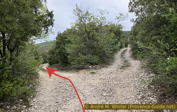
First junction on the track towards Bergerie Cabrone
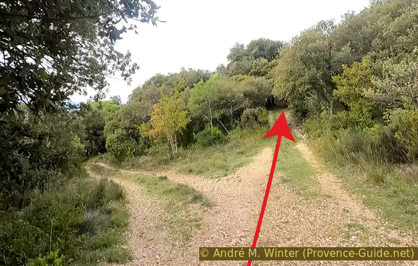
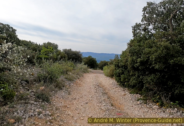
It starts to lead upwards again and the gravel starts to get a little bigger again. On the left then follows a flat and open space. The view is clear to the west. We see a rocky bar which protrudes in places from the low forest. The widest and smoothest part in the middle is the one under which the Bergerie Cabrone is located.
No reproduction is permitted without the written consent of the author. (id7370)
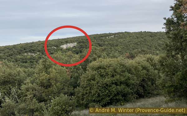
View towards the rocks of Bergerie Cabrone
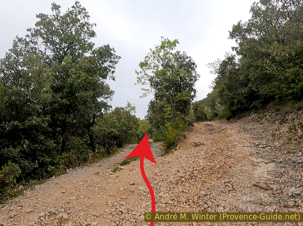
Afterwards, we ride peacefully and pass a significant turn to the left. Just after, a very steep passage on the rock begins. You have to go through it in one go because it's difficult to restart in the middle.
No reproduction is permitted without the written consent of the author. (id7371)
Rocky soil on the track towards Bergerie Cabrone
Beyond that point, it becomes easier and much flatter again. At the next fork, left again.
No reproduction is permitted without the written consent of the author. (id7372)
Second junction on the track towards Bergerie Cabrone
We pass a hairpin bend in the Ravin des Seysses which is very flat here. Shortly after, follow the sign Voie privée sans issue (private road and cul-de-sac). This is doubly true. This is a private site, but access is authorized. It's rare enough to be noticed positively here.
No reproduction is permitted without the written consent of the author. (id7373)
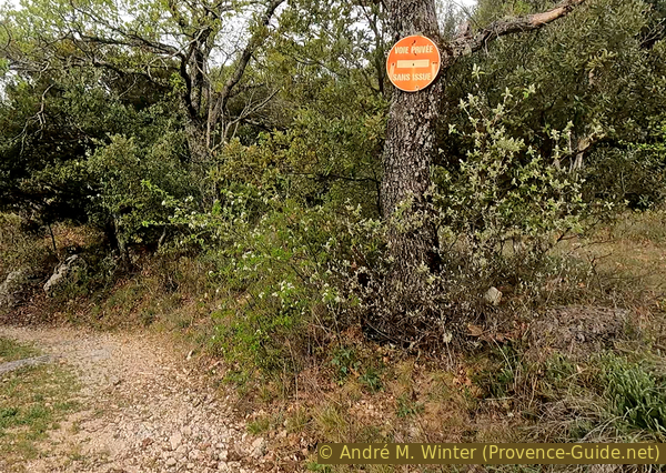
Private road sign
Apart from a few stones on the road, this last part is easy. The next fork is to take right and we are already under the rocky bar with the troglodyte installations below. Let's leave the mountain bike here. It is unnecessary and undesirable to perform acrobatics here.
No reproduction is permitted without the written consent of the author. (id7374)
Last junction on the track towards Bergerie Cabrone
Section 2: Bergerie Cabrone
➙ 0,1 km ... 10 min ➚ 10 m ➘ 10 m ↝ easy
100% easy trails, without marks
↖ leave the bike and explore on foot
The clues
- Bergerie Cabrone, 800 m
This troglodytic ensemble includes two large converted caves, a third serving as a cistern and a classic hut built in front.
We arrive from the top and first pass on caves left in their natural state. One only created installations in caves with flat ground and easy access.
No reproduction is permitted without the written consent of the author. (id7375)
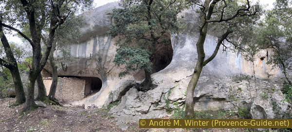
Open caves at Bergerie Cabrone
The first cave with installations is the largest. It houses the stable and a cabin added to the right without it reaching the natural ceiling.
No reproduction is permitted without the written consent of the author. (id7376)
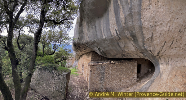
The troglodyte stable at Bergerie Cabrone
The interior of the troglodyte stable forms a large hall whose floor rises quickly. These stable sheltered sheep and goats, both of which can also climb the natural slope of the cave. An intermediate platform is built for goats. Cabre means goat in Provencal, the farm is called Cabrone.
No reproduction is permitted without the written consent of the author. (id7378)
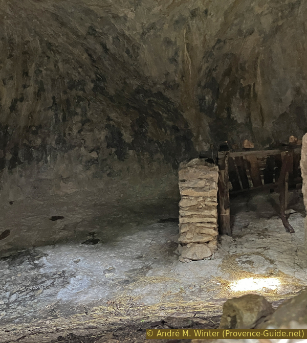
Interior of the troglodyte stable at Bergerie Cabrone
Above the cliff is a water collection system. These are mainly channels and a large basin. This water was needed because there is no permanent source nearby. The water diversion also prevents runoff onto the troglodyte constructions below. It is possible to see these elements chiseled in the rock by going up the path on the left under the stable and continuing to go left.
The little cave on the left is walled up more carefully. It houses a cistern with a drinking trough in front. This cistern is fed by the channels above.
No reproduction is permitted without the written consent of the author. (id7379)
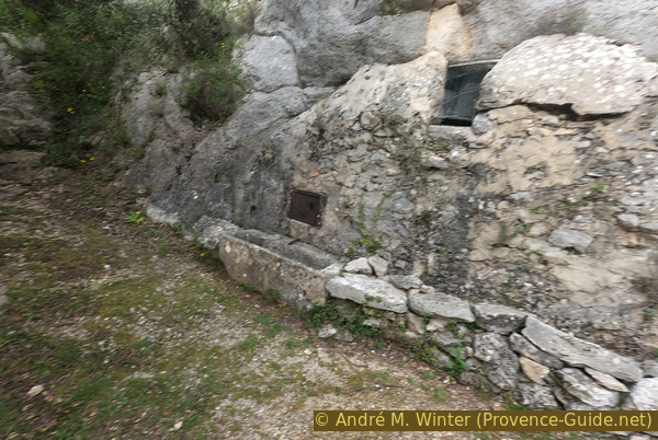
Dry fountain of the Bergerie Cabrone
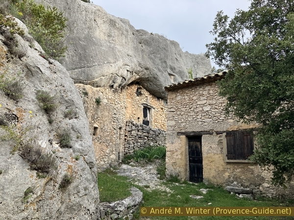
Between the cistern and the stable there is a two-part troglodyte dwelling which completely fills its cave. These are private and closed.
The hut built in front of the troglodyte sheepfold dates later as the construction in the rock. This corresponds to the need for more living space perhaps less humid and less cold.
This complex arrangement met the needs for long periods of self-sufficient life in the mountains.
No reproduction is permitted without the written consent of the author. (id7380)
Troglodytic dwelling and isolated cabin at Bergerie Cabrone
Section 3: Bergerie Cabrone - D34
➙ 1,2 km ... ➚ 10 m ➘ 62 m ↝ easy
↙ Colours of the sections like MTB rating but without the duration.
45% forest roads, without marks
15% difficult trails, without marks
↖ very steep passages
25% forest roads, without marks
15% coarse gravel, without marks
↖ very steep passages
<5% hard-surfaced quiet side streets, without marks
The clues
- Bergerie Cabrone, 800 m
- Ravin des Seysses, 810 m
- Car park along D34 road, 750 m
Time for the downhill. It will not be much faster than the climb because some passages are difficult.
We resume the easy part which passes through the hairpin bend of Ravin des Seysses.
No reproduction is permitted without the written consent of the author. (id7381)
Return to the track
It continues easily until the rocky part. It was annoying going uphill, but it's more terrifying going downhill.
No reproduction is permitted without the written consent of the author. (id7382)
Downhill rocky section
Afterwards, the easy stuff starts again. However, be careful of stones rolled on the road.
The last piece on the large rubble shakes a lot, but these stones are large enough not to slide under the tires when braking. Because you have to brake, the slope is significant.
No reproduction is permitted without the written consent of the author. (id7383)
Easy downhill section
Sources and additional information
This tour is inspired by this book: 25 balades sur les chemins de la pierre sèche (25 Hikes on tracks of the dry stone constructions, only french) between Monts de Vaucluse, Montagne de Lure and Lubéron, by Florence Dominique, Le bec en l'air publisher, ISBN 987-0-916073-45-3. If you are more interested in these constructions, this book will also pass on well-founded knowledge. The tours are well explained with pictures and maps.
It is better to use a good topographic hiking map: this tour is on the IGN map "Apt, Parc naturel régional du Luberon", scale 1:25000, 3242OT.
If you don't want to bother with a paper map, you can also use mapping apps on your cell phone. On the one hand, it is the Cartes IGN app from the official map service. However, it requires access to the data network and this is sometimes difficult in canyons or remote locations.
Alternatively, you can use apps that store data directly on the device. They're generally not free, but they don't cost much. We mainly use OSMAnd, here it is possible to add contour lines, relief shading, markings and others. To store this data on your phone you need a lot of space.
Of course, one needs access to satellites for the GPS signal with any app. In some canyons this is not the case. Therefore, do not rely on the position shown, but read the map on your phone as you would read it on paper. Most apps are available for Android and iPhone. The applications usually allow us to record the route travelled and also view the GPS files offered for each of our hikes.
This page has been seen 1662 times since 20 March 2024.
No reproduction is permitted without the written consent of the author. (id7384)
Large stones and concrete before the D34 road