The original monuments of Tourves
A colonnade, an obelisk and a pyramid
walk
easy
1 h 15 min
yes
yes
built-up area
walk
Introduction
Tourves is a village in the Var department's hinterland. Quite original monuments can be found on the nearby former castle hill. You can join them on a hike of about an hour duration. We usually avoid walking town tour descriptions because other guides do it better, but we make an exception for Tourves!
The facts
4,7 km total distance
1 h 15 min walk time
60 m total elevation
orientation easy
mark 0% of the total distance
65% hard-surfaced city alleys
15% dirt roads
10% easy trails
10% cross country
dangers none
children yes
useful water
required trekking shoes
GPS coordinates (WGS84) of start and end point 43.411659,5.920534
downloads ![]()
![]()
Public transport
The village of Tourves is located along the axis of several important lines by Zou! (only french), including lines express busses 92 an 93 from Brignoles and bus 849 from Toulon. The hike starts at the bus station north of the village.
Access by car
Tourves is on the former Route Nationale 7 between Aix-en-Provence and Saint-Raphaël, more precisely between St.-Maximin-la-Ste.-Baume and Brignoles. We leave the DN7 east of the village. 300 meters after passing under the old railway line, we turn left onto the narrow Avenue Charles Gaou. When you get to the centrê of town, stay to the left without turning right.
Useful parking spaces
There are two parking lots south of the village. Walk up towards the centre to join the route of the walk on Rue Paul Rougiers, keep left here.
No reproduction is permitted without the written consent of the author. (id5823)
Tourves colonnade
Hints
There are some nice cafés with terraces on the town hall square and in the alley in the direction of the Cours de la République.
Behind the bus stop is the Musée des Gueules Roues, which traces the mining past of the area between Mazaugues and Tourves. Bauxite was mined here until the 1960s.
The whole region is a zone with a high risk of forest fires. In summer, but also in other seasons when it is very dry or by strong winds, access to the forest areas can be regulated. As a result, the roads may be closed to traffic and/or the trails prohibited to hikers. Current information: Map of access to the forests of the Var (also english). The map shows the colours green, yellow, orange and red which correspond to levels of danger.
The sections
- Bus stop - Place de l'Hôtel de Ville
- Place de l'Hôtel de Ville - La Laiterie
- La Laiterie - Bus stop
Section 1: Halte Routière - Place de l'Hôtel de Ville
➙ 1,2 km ... 20 min ➚ 5 m ➘ 5 m ↝ easy
100% hard-surfaced city alleys, without marks
The clues
- Tavernes bus stop, 285 m
- Cours de la République, 290 m
- Place de l'Hôtel de Ville, 285 m
We pass the Bauxite Mine Museum to reach the village center and explore its squares and alleys.
The bus stops quite far north of the village. We leave the Gueules Rouges Museum on the right and walk along the straight Avenue Gambetta. At the end of the avenue we turn left behind a small park with two plane trees.
We pass the Fontaine du Can and continue straight towards the center of the village, ignoring the arrows for the Château de Valbelle. At the end, Rue Voltaire becomes very narrow and we turn left into Rue Sidi Carnot.
This is how we get to the Église l'Annonciade church and the attached fountain.
The construction of the original church was completed in 1470, but the current version dates from the 17th century. The baptismal font is part of the former Château de Valbelle.
The fountain at the corner of the church is a new installation from 1792, as it hindered the goods carts in the market square. There have been wells in the village since the beginning of the 16th century, in the first half of the 20th century there were 17 wells.
No reproduction is permitted without the written consent of the author. (id5819)
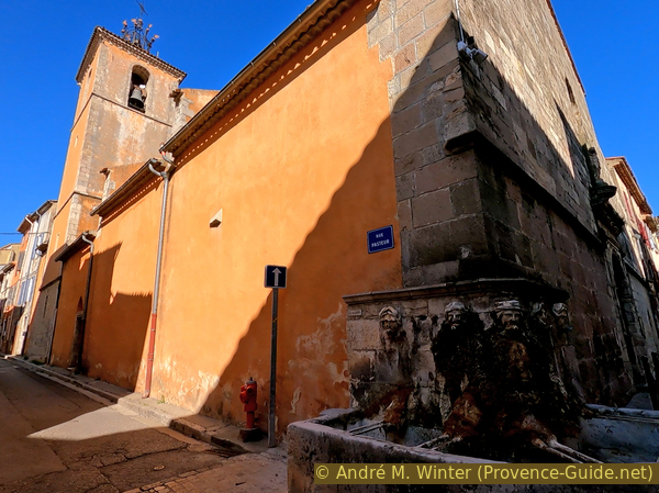
Église de l'Annonciade church and fountain
Further ahead, the road turns right, but we turn left immediately afterwards into the narrow Rue Marceau. In front on the main street turn right up to Place de l'Hotel de Ville and left at the pharmacy. The Rue Victor Hugo has a nice little square, further ahead is the Cours de la République, where the market takes place.
No reproduction is permitted without the written consent of the author. (id5699)
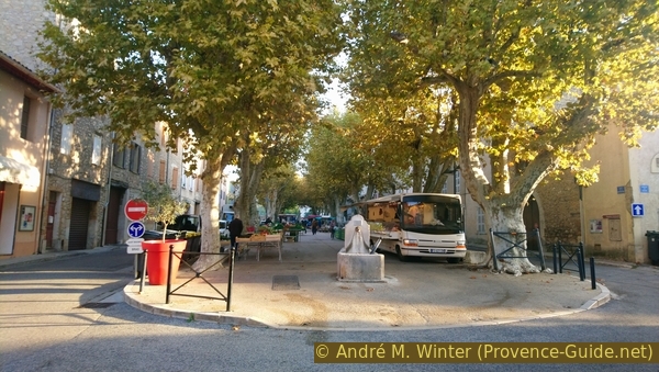
Tourves market on Cours de la République
We go back down Rue Victor Hugo and come back to Place de l'Hotel de Ville. Needless to say, the café terrace is very attractive.
The fountain was an ornament in the former palace park.
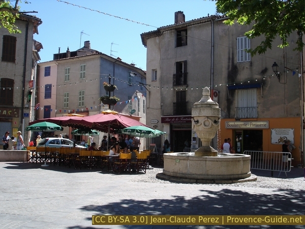
The fountain on the main square in Tourves
Section 2: Place de l'Hôtel de Ville - La Laiterie
➙ 2,1 km ... 30 min ➚ 45 m ➘ 35 m ↝ easy
20% hard-surfaced city alleys, without marks
15% easy trails, without marks
10% dirt roads, without marks
20% cross country, without marks
15% dirt roads, without marks
10% easy trails, without marks
15% dirt roads, without marks
The clues
- Place de l'Hôtel de Ville, 285 m
- Railway line, 290 m
- Stables, 320 m
- Castle of Tavernes, the colonnade
- Obelisk, 315 m
- Pyramid, 325 m
- La Laiterie, 295 m
We climb the hill where originally the village was located near the castle.
We cross the town hall square and continue on rue Sidi Carnot.
Number 4 is one of the houses on the right, Léon d'Astros, doctor, mayor of the village and Provencal author was born here. He campaigned for the Provençal language years before the Félibrige movement was founded. This association continues to work with the aim of protecting and promoting the language, culture and everything that makes up the identity of the countries of the Langue d'Oc.
No reproduction is permitted without the written consent of the author. (id5820)
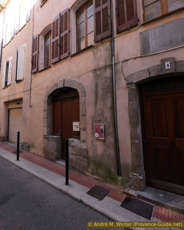
Birthplace of Léon d'Astros
We follow rue Carnot to return to the church with the fountain, then continue straight on rue Paul Rougiers, which climbs slightly as you leave the centre.
As we enter an area of green front gardens, we pass the now private Saint-François Chapel.
In the 19th century it housed the brotherhood of the Pénitents Noirs. The brotherhoods of Black Penitents had the mission of accompanying the salvation of souls and bodies, therefore moral and material aid to prisoners, assistance to those sentenced to death and to the sick.
No reproduction is permitted without the written consent of the author. (id5799)
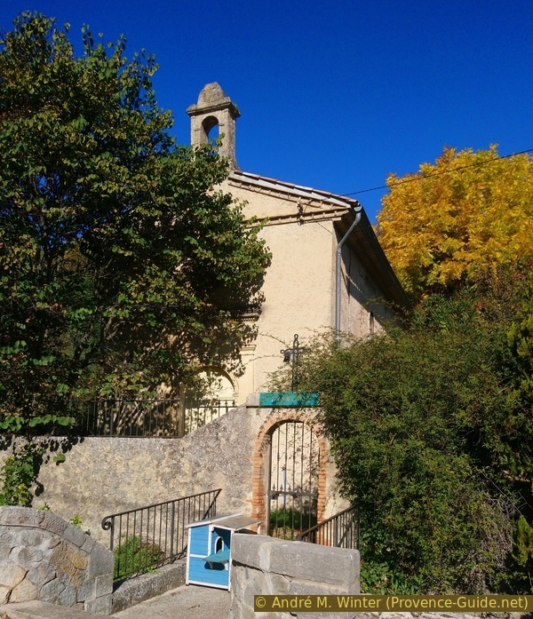
Saint-François chapel
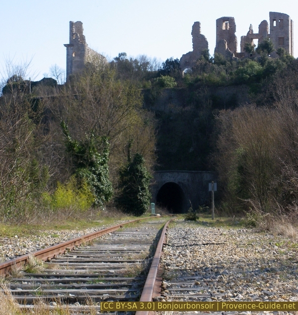
Ahead is a level crossing with no signs or barriers.
This is the line from Carnoules to Gardanne, which unfortunately is entirely abandoned in this part.
No reproduction is permitted without the written consent of the author. (id5800)
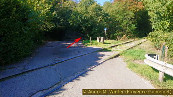
Carnoules to Gardanne railway line in front of the tunnel under the castle hill
After crossing the railway line, we come in front of the tunnel under the expressway. There we go up to the right into the high forest. On the way we see old canal systems that must have been part of the landscape park of the last aristocratic owners.
At the beginning of the 18th century, the castle was in the hands of the Counts of Valbelle, who massively remodelled the complex and its surroundings. The rest of the village and its churches on the hill are demolished to form the large square and a large park with follies, elements of garden art such as the colonnade or the obelisk, an architectural practice not very common in this part of France is. This Augustan park extended on both sides of the castle and on the terraces below the hill. The retaining walls are still visible today. The castle fell into disrepair after the revolution, but the park has been preserved without being taken care of.
No reproduction is permitted without the written consent of the author. (id5801)
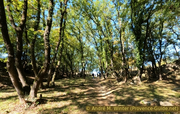
Up to the stables of the castle
The path leads us directly to a fairly well-preserved building. These are the stables of the castle.
Only its north facade is equipped with an imposing facade. These so-called Egyptian stables mark a distinct taste for the Orient.
No reproduction is permitted without the written consent of the author. (id5802)
The stables south side
At the stables we turn right and enter the remains of the Parc d'Auguste.
The entrance was marked by a large neoclassical stone urn from the 1760s, which now forms the fountain on the Place de l'Hotel de Ville.
In the background you can see the corners of one of the buildings of the castle.
It is mentioned for the first time in 1002. The castle is the property of several aristocrats such as Raymond de Baux, the d'Arcussia family, the Vintimille family and finally the Valbelle family.
No reproduction is permitted without the written consent of the author. (id5803)
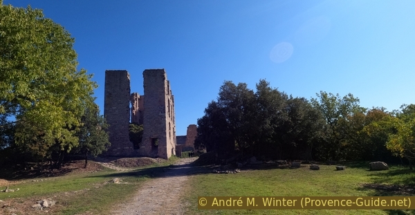
The castle seen from north-west
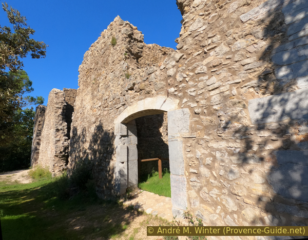
We pass under an arch of the castle. You can walk through the ruins to the left, but they are more impressive from the outside.
In front of us is a dark wall, which you go around on the right.
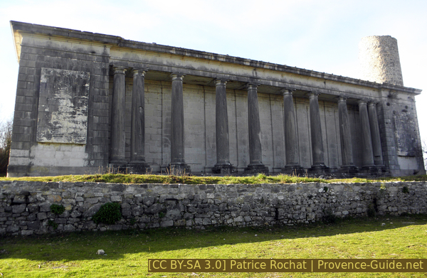
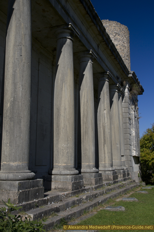
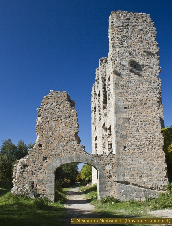
The colonnade near the castle
We come to the esplanade in front of the colonnade.
The Esplanade is a large terrace or agora, now a large lawn, under which lie buried the remains of the medieval village of Tourves.
The Greek-style colonnade consists of seven main columns. Artistic representations were given in front of this neoclassical building
20 years before the French Revolution, Omer de Valbelle organises the encounter of the privileged with the philosophical spirit of the Enlightenment and the return to nature with the taste of English gardens. He creates paths of initiation on which symbolic images, dreams and values from antiquity were implemented in a new way.
The Obelisk is a dynastic mausoleum of the Valbelle family. It is a replica of the Obelisk of Sextius in Rome. This Egyptian-style monument finds its counterpart on the other side of the park in the form of a pyramid-shaped ice house, which we will discover in a moment.
No reproduction is permitted without the written consent of the author. (id5822)
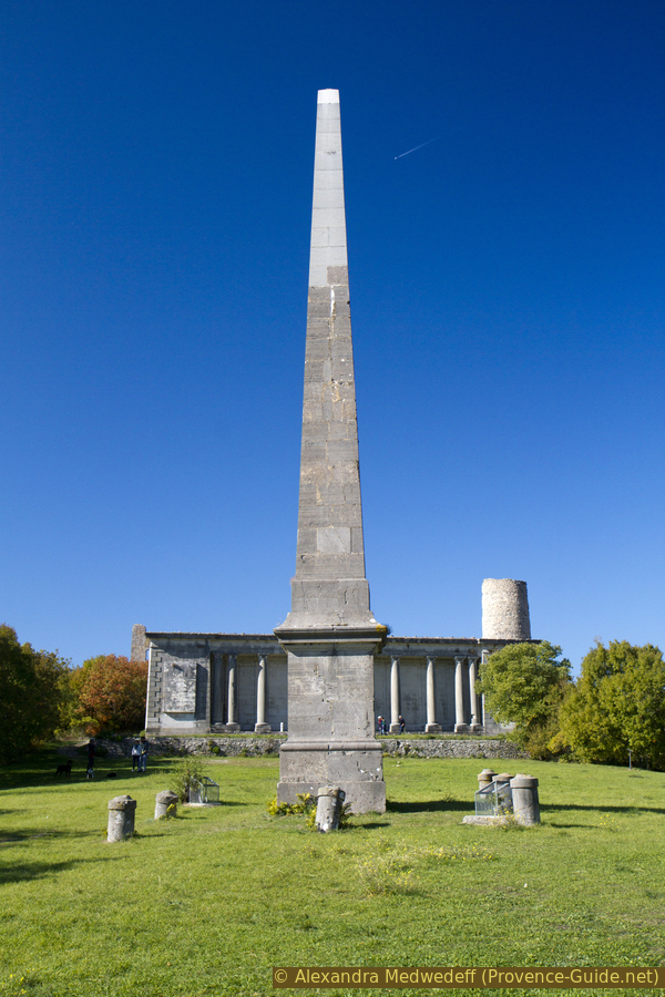
Colonnade and copy of the Sextus Obelisk
We go back again to pass under the arch of the castle ruins.
We also pass the stables again, which show their most beautiful facade here.
No reproduction is permitted without the written consent of the author. (id5804)
The castle's west side
We then walk along this old central avenue and after two minutes or 200 meters we find a path on the right. It leads to another straight aisle in the forest.
No reproduction is permitted without the written consent of the author. (id5815)
Path to the pyramid
We then see a truncated pyramid on the left. It looks like the Egyptian pyramids today in miniature.
The Count of Valbelle, initiated into the Egyptian rite of Freemasonry, had it built around 1770. The entrance is on the north side, which is quite logical for an ice house.
Access is blocked in 2021. It seems the pyramid has been renoved 2024.
No reproduction is permitted without the written consent of the author. (id5816)
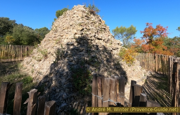
The pyramidal ice house
We return to the main avenue and this leads us downhill to a junction with the expressway. There were undoubtedly peaceful fields here in the days of the castle.
Opposite we see a ruined tower, it is the former old Sainte-Estève chapel. The building is private and entry is prohibited.
Sainte-Estève chapel
We stay on the path to the right of the road and go down to a building called La Laiterie or La Vacherie.
Originally covered with lead panels, this building was a model of intensive cattle breeding: regularly spaced boxes for milking, marble surfaces for easy work and cleaning etc.
No reproduction is permitted without the written consent of the author. (id5817)
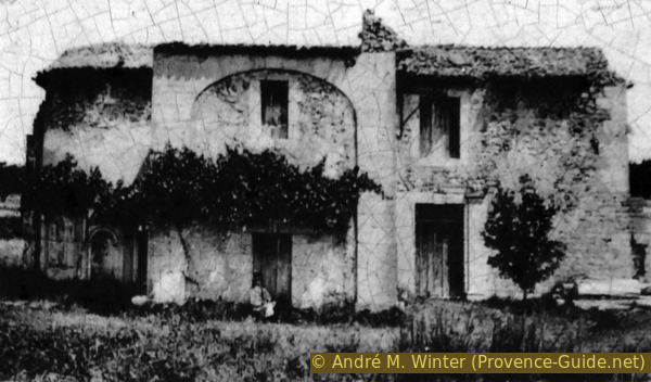
The farm around 1910
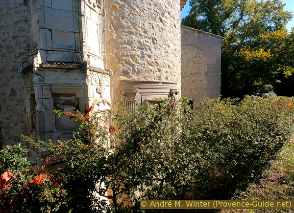
This courtyard was designed in the 18th century also to unite the elements of three buildings: the old church of the castle, an imitation of Roman ruins and two ancient openings form the entrance to the stable, surmounted by a hayloft.
No reproduction is permitted without the written consent of the author. (id5818)
Imitations of Roman ruins
Section 3: La Laiterie - Halte Routière
➙ 1,4 km ... 25 min ➚ 5 m ➘ 15 m ↝ easy
55% hard-surfaced city alleys, without marks
5% easy trails, without marks
40% hard-surfaced city alleys, without marks
The clues
- La Laiterie, 295 m
- Railway line, 300 m
- Dovecote, 295 m
- bus stop, 285 m
The return to the starting point.
We leave the former farm building behind us and walk along the long road in the direction of the village. At the first notable crossing, turn left onto Den Chemin de la Foux, we are now walking along the abandoned tracks that come out of the tunnel under the castle. After a while you can see back to the castle across the train tracks.
We then see a round tower on the right, this is an old dovecote.
Several of these towers are still standing in Provence, and pigeon breeding was historically reserved for the aristocrats.
At its level, a path crosses the tracks. On the other side we come to Avenue Gambetta, planted with plane trees. Left here to return to the starting point at the Halte Routière bus stop and the Musée des Gueules Rouges or straight ahead to reach the village centre.
Old railway under the castle hill
Sources and additional information
It is better to use a good topographical hiking map: this tour is on the IGN "Signes/Tourves/Massif de la Sainte-Baume" map, scale 1:25000, 3345OT.
If you don't want to bother with a paper map, you can also use mapping apps on your cell phone. On the one hand, it is the Cartes IGN app from the official map service. However, it requires access to the data network and this is sometimes difficult in canyons or remote locations.
Alternatively, you can use apps that store data directly on the device. They're generally not free, but they don't cost much. We mainly use OSMAnd, here it is possible to add contour lines, relief shading, markings and others. To store this data on your phone you need a lot of space.
Of course, one needs access to satellites for the GPS signal with any app. In some canyons this is not the case. Therefore, do not rely on the position shown, but read the map on your phone as you would read it on paper. Most apps are available for Android and iPhone. The applications usually allow us to record the route travelled and also view the GPS files offered for each of our hikes.
This page has been seen 2464 times since 20 March 2024.