Sainte-Marie-Madeleine grotto and Saint Pilon chapel
Ascent and descent over different passes
hike
average
2 h 15 min
no
yes
shelter
mountain
Introduction
The Sainte-Baume massif is a calcareous bar of similar size, geology and orientation as the Montagne Sainte-Victoire. There is also less than 25 km as the crow flies between the two. But the Sainte-Baume massif did not have its Cézanne, the elevation is far from any major city and not so easily accessible. Historically, however, the Sainte-Baume massif is far more important, since Roman times it has been the sacred mountain of Marseille and a center of a cult of fertility.
The Sainte-Marie-Madeleine (Mary Magdalene) cave has been a place of pilgrimage since the fifth century. Its level of awareness increased until the 15th century in such a way that the cave was one of the most important Christian pilgrimage sites at that time. A legend was constructed quite successfully about the follower and possible lover of Jesus of Nazareth. The invented story says that she crossed the Mediterranean alone in a wooden boat and successfully evangelized Marseille, only to withdraw later to the cave for 30 years.
Regardless of these hair-raising and power-political myths, the massif is also a popular hiking area, where things are quieter than on the Montagne Sainte-Victoire. The terrain is no less impressive. We take the classic approach to the grotto, but continue via a little-used rock passage in the Pass Pas de la Cabre to the main ridge.
The facts
6,3 km total distance
2 h 15 min walk time
400 m total elevation
orientation easy on marked paths, appealing to the Pas de la Cabre
mark 70% of the total distance
65% easy trails
15% exposed trails
10% forest roads
5% dirt roads
5% moderate trails
5% stairs
dangers heat in summer, cold and icy roads in winter, wind
children yes
useful picnic stuff
required hiking boots, hiking equipment and water
GPS coordinates (WGS84) of start and end point 43.335534,5.758928
downloads ![]()
![]()
No reproduction is permitted without the written consent of the author. (id3148)
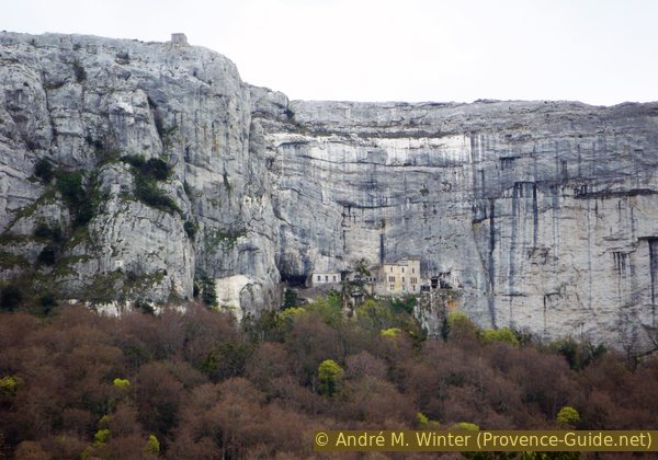
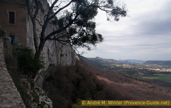
Sainte-Baume with Saint-Pilon and Cave Marie-Madeleine
View from the starting point. The Saint-Pilon is one of the peaks of the main ridge, but not the highest one, at the top there is a bare chapel. The buildings in the cliff above the tree line face the Sainte-Marie-Madeleine cave and house a few monks and sometimes pilgrims.
Public transport
You cannot get to the starting point by public transport. Although there are several access roads, fast access is not possible. The nearest town of note with good public transport links is Aubagne, from there it is 30 km by road to the village of Plan d'Aups. The starting point is 3 km east of the village.
Access by car
A village is close to the starting point, but that doesn't mean it's easy to get there. From Aubagne, it's an alpine climb over hairpin bends and 30 km over the D2 road to the north side of the plateau. No less winding alternatives are: the D45a from Auriol, the D480 from Saint-Zacharie and the D80 from Nans-les-Pins and Saint-Maximin. The roads to the east are a little less winding, but Brignoles is also a 30 km drive. The destination is always Plan-d'Aups-Sainte-Baume.
Useful parking spaces
We recommend the parking areas to the east of the Hôtellerie Sainte-Baume buildings. These off-road parking spaces are sufficient even when there are large crowds. This is also the starting point of the tour.
Hints
The ridge is oriented east-west and is therefore at right angles to the Mistral and most of the other prevailing wind directions here. At the ridge, the wind can become unbearable and even dangerous. On these days you should avoid the ridge and not aim for the Saint-Pilon chapel. The Sainte Baume massif lies on a huge limestone surface and is surrounded by other large mountains, clouds also last longer here than on the coast. Nevertheless, the sun can also burn down unbearably hot. The ascent takes place on the north side in the shade of the trees. On the ridge you are totally exposed to the weather, and there is hardly any vegetation here.
The grotto can be used as a shelter, but it is uncomfortably cold and damp all year round.
The whole region is a zone with a high risk of forest fires. In summer, but also in other seasons when it is very dry or by strong winds, access to the forest areas can be regulated. As a result, the roads may be closed to traffic and/or the trails prohibited to hikers. Current information: Map of access to the forests of the Var (also english). The map shows the colours green, yellow, orange and red which correspond to levels of danger.
The sections
- Ascent on the classic pilgrimage route to the grotto
- Via the Pas de la Cabre saddle to the west and the ridge path to the Saint Pilon chapel
- Ridge path and descent via the Col de St Pilon, Chemin du Canapé and Chemin des Rois
No reproduction is permitted without the written consent of the author. (id3135)
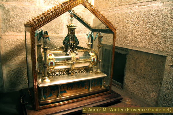
Suspected relic of Mary Magdalene
Section 1: Hôtellerie - Grotte de Sainte-Marie-Madeleine
➙ 1,8 km ... 45 min ➚ 220 m ➘ 0 m ↝ easy
25% dirt roads, with marks
75% easy trails, with marks
5% stairs
The clues
- Hôtellerie de la Sainte-Baume, 670 m
- Cave Sainte-Marie-Madeleine, 892 m
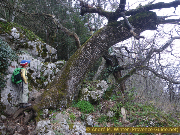
Ascent through a dense oak and beech forest. It can be very cold here in winter.
The path is easy and well signposted. You start at the parking lot east of the large and old hostel and walk directly and straight between two fields towards the mountain. Then right and then left again and now continue on the actual pilgrimage route.
No reproduction is permitted without the written consent of the author. (id3131)
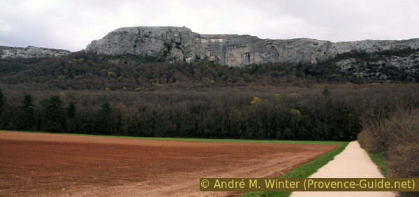
Massif de la Sainte-Baume seen from the north
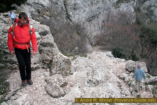
The pilgrimage route is provided with stairs made of natural stones, depending on the personal step length, they can be considered practical or annoying. We stay in this dense forest for a long time and only see the grotto at the foot of the rock wall when we are directly below it. In summer the forest provides good shade.
No reproduction is permitted without the written consent of the author. (id3132)
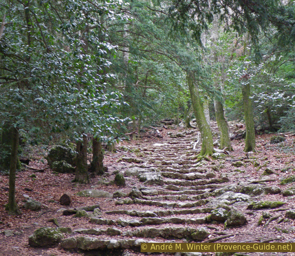
Pilgrimage path to the Sainte-Marie-Madeleine cave
The path makes a few curves and comes to a large crossroads with a wayside shrine, here on the right.
No reproduction is permitted without the written consent of the author. (id3146)
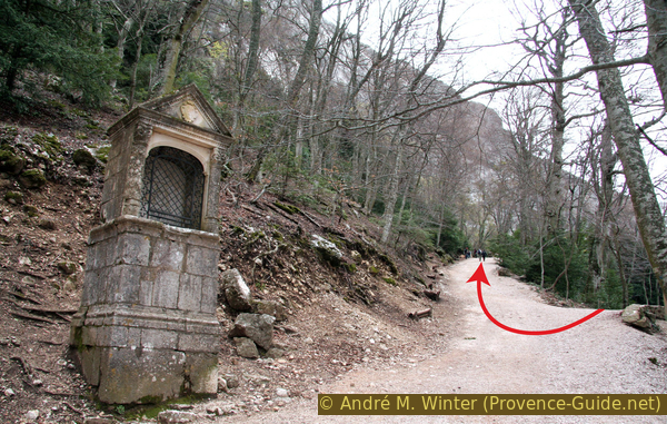
Shrine at 380 metres
We continue to climb without significant clues and only at the last moment the green curtain opens in front of the buildings near the cave. On the left stairs lead up into the half-cave.
No reproduction is permitted without the written consent of the author. (id3133)
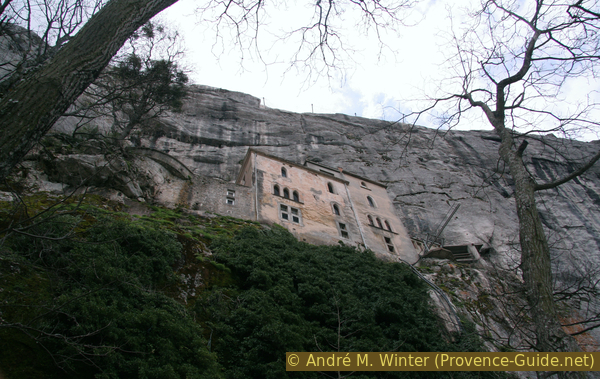
At the foot of the built-in cave of Maria Magdalena
It is not a single cave, but several openings. All are provided with crosses or with constructions. The largest natural opening is bricked up and houses the chapel.
No reproduction is permitted without the written consent of the author. (id3134)
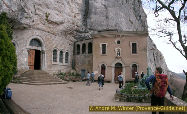
Forecourt of the Marie-Madeleine cave
Inside it looks like a church, side chapels are in natural side caves. The kitschy 19th century style is depressing.
No reproduction is permitted without the written consent of the author. (id3136)
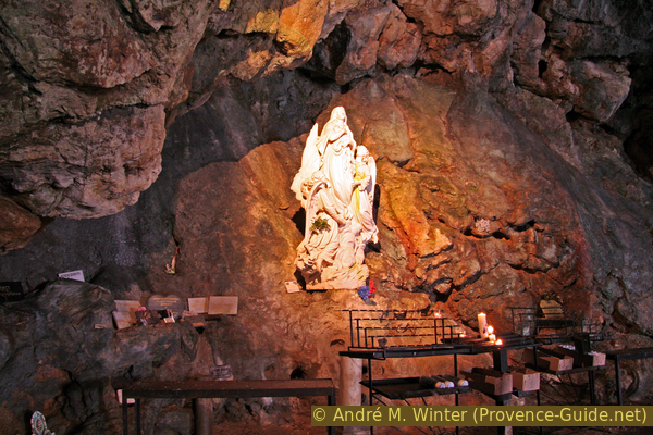
Statue in the Grotte de Sainte-Marie-Madeleine
Section 2: Grotte - Pas de la Cabre - St. Pilon
➙ 1,9 km ... 45 min ➚ 160 m ➘ 65 m ↝ average
5% stairs
45% exposed trails, without marks
50% easy trails, with marks
The clues
- Cave Sainte-Marie-Madeleine, 892 m
- Pass under the cave and head west near the foot of the cliff
- Saddle Pas de la Cabre, 960 m
- Chapel Saint-Pilon, 980 m
Discreetly marked but demanding ascent into the ridge.
If we go down the stairs from the cave again, we can get a glimpse of the further route at the beginning. You can see to the west into the limestone wall, which rises more than 100 metres higher here. Further back you can see a rock ramp that starts at the foot of the wall. This is our natural transition into the crest.
No reproduction is permitted without the written consent of the author. (id3137)
North side of the Sainte-Baume massif, looking west
So we go down the stairs, turn left and stay as close to the rock wall as possible. Old red markings show the way between the rock and the thick beech trunks.
No reproduction is permitted without the written consent of the author. (id3139)
Path at the foot of the wall
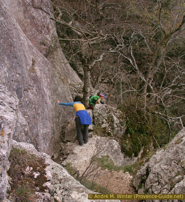
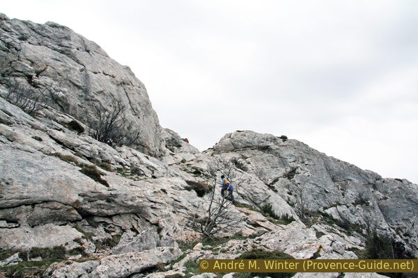
The path requires some scrambling and using your hands!
No reproduction is permitted without the written consent of the author. (id3138)
It goes up and down at the foot of the wall
By staying close to the rock wall, we come straight to the natural rock ramp. In the photo you can see it looking back, with the cube-shaped Saint-Pilon chapel at the top centre.
No reproduction is permitted without the written consent of the author. (id3140)
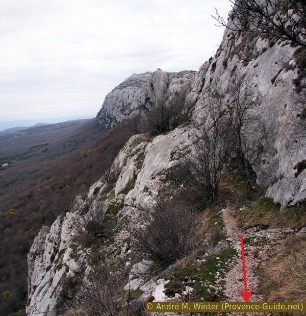
Northeast under the Pas de la Cabre saddle
The Pas de la Cabre saddle marks the end of our ramp and the transition to the ridge. You just get up here over flat rock. At the top we keep to the left to take the ridge path.
No reproduction is permitted without the written consent of the author. (id3141)
Just below the Pas de la Cabre
The path now marked runs a few metres below the ridgeline. It doesn't make sense to look over the edge here. This is better and easier to do at the St. Pilon chapel.
No reproduction is permitted without the written consent of the author. (id3142)
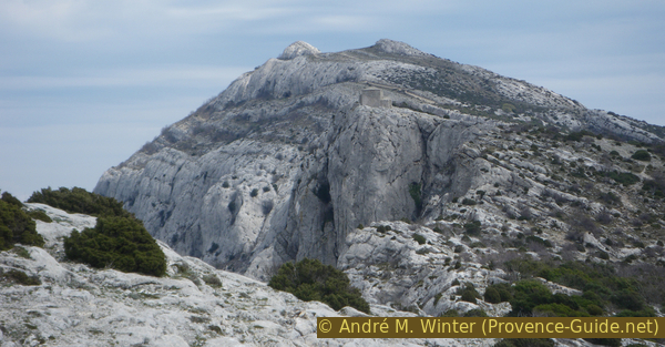
St. Pilon and the elevations in the eastern part of the massif
We aim for this chapel, you can see it at times from the path. It is open and you can shelter here by wind and weather.
There's no point in leaning over the low wall or craning your eyes elsewhere, you can't see the Sainte-Marie-Madeleine chapel from up here! It is better to look at the panoramic views, for example to Six-Fours-les-Plages on the sea to the south-east or the Montagne Sainte-Victoire to the north-west.
No reproduction is permitted without the written consent of the author. (id3143)
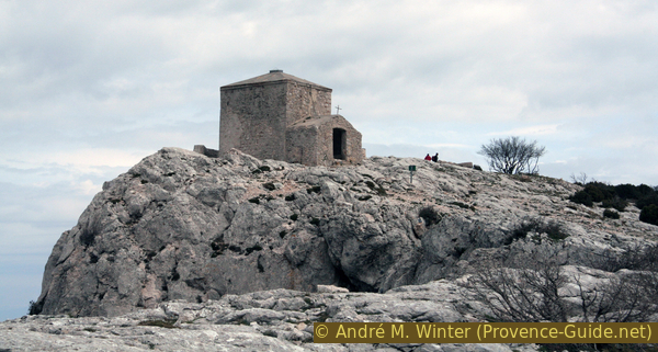
Chapelle de St. Pilon
Section 3: St. Pilon - Chemin des Rois - Hôtellerie
➙ 2,6 km ... 45 min ➚ 20 m ➘ 335 m ↝ easy
10% moderate trails, without marks
70% easy trails, with marks
20% forest roads, without marks
The clues
- Saint-Pilon chapel, 980 m
- Col de Saint-Pilon saddle, 980 m
- Chapelle des Parisiens, 860 m
- Hôtellerie de la Sainte-Baume, 670 m
Descent on easier paths along several shrines.
After the Saint Pilon chapel, it's all downhill, first we descend further to the east and thus a little to the south. This is how we get to the Col de Saint-Pilon saddle, where we switch back to the north side.
No reproduction is permitted without the written consent of the author. (id3144)
Descent over Col de Saint-Pilon saddle
In a few hairpin bends we come to the Chapelle des Parisiens, after which the path becomes easier and wider.
The additional sign "chaussée déformée" (bumpy road surface) is a bit out of place on this mountain trail.
No reproduction is permitted without the written consent of the author. (id3145)
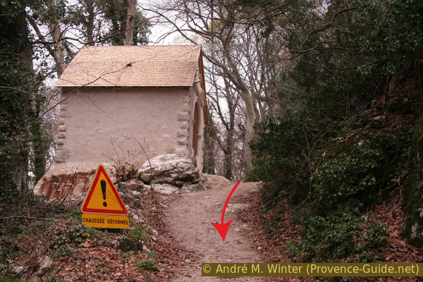
Chapelle des Parisiens
oratoire = shrine
We come back to the large crossroads in the forest, keep to the right to take another path for the further descent.
Shortly afterwards we pass the fountain of the Source de Nans. Attention, water is not always available here.
The further path leads down in the forest. So we come to the road just east of the starting point and at another parking lot. You don't have to walk on the road, there are agricultural paths parallel to come back to the starting point.
No reproduction is permitted without the written consent of the author. (id3147)
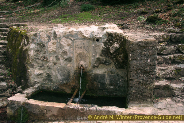
Source de Nans
Sources and additional information
It is better to use a good topographical hiking map: this tour is on the IGN map "Signes, Tourves, Massif de la Sainte-Baume", scale 1:25000, 3345OT.
If you don't want to bother with a paper map, you can also use mapping apps on your cell phone. On the one hand, it is the Cartes IGN app from the official map service. However, it requires access to the data network and this is sometimes difficult in canyons or remote locations.
Alternatively, you can use apps that store data directly on the device. They're generally not free, but they don't cost much. We mainly use OSMAnd, here it is possible to add contour lines, relief shading, markings and others. To store this data on your phone you need a lot of space.
Of course, one needs access to satellites for the GPS signal with any app. In some canyons this is not the case. Therefore, do not rely on the position shown, but read the map on your phone as you would read it on paper. Most apps are available for Android and iPhone. The applications usually allow us to record the route travelled and also view the GPS files offered for each of our hikes.
This page has been seen 7269 times since 20 March 2024.