From Col de Moissière to Saint Philippe summit
Small mountain in Champsaur with a great panorama
hike
easy
1 h 45 min
no
yes
no
mountain
Introduction
This tour leads to the inconspicuous Saint Philippe peak in the centre of Champsaur, offers a magnificent all-round view from the foothills of the Vercors, the Massif des Écrins and in the south of Gap to the Serre-Ponçon reservoir. At the foot of the summit lies the dilapidated village of Faudon, whose history has still not been fully clarified. All of this can be accomplished in a loop that's easily manageable in under two hours and with less than 250 meters of elevation gain.
The facts
5,7 km total distance
1 h 45 min walk time
230 m total elevation
orientation easy
mark 85% of the total distance
50% forest roads
35% easy trails
10% moderate trails
5% hard-to-recognize trails
dangers snow in winter, wind
children yes
useful picnic stuff
required hiking boots, hiking equipment and water
GPS coordinates (WGS84) of start and end point 44.600116,6.220536
downloads ![]()
![]()
No reproduction is permitted without the written consent of the author. (id3690)
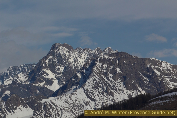
Le Sirac, 3441 m, seen from Saint Philippe summit
Public transport
You cannot get to the starting point by public transport. Not even the village of Ancelle is accessible that way outside of the ski season. It takes about 30 minutes by taxi from the train station in Gap to the starting point at the pass. If you start on foot from Ancelle, you have to add a good hour and 240 meters of altitude difference to get to the starting point of the tour described here.
Access by car
The starting point is on a pass north of a main thoroughfare between Lac de Serre-Ponçon and Gap. The fastest access is via the D213T road from Bâtie-Neuve. Coming from the lake, leave the N94 main road at the La Grand Île business park and join the D614 pass road. Coming from Gap, take the Tallard exit on the South bypass to avoid the centre of Bâtie-Neuve. It is also possible to approach the pass from the north via Ancelle. Attention, this pass road is closed in winter!
Useful parking spaces
Small parking lot in a curve at the Col de Moissière pass. Do not block accesses to agricaltural roads.
Hints
The tour can be undertaken at any time of the year, even in winter, it is possible to walk here with snowshoes when the risk of avalanches is low. In this case the road is closed, but it is possible to take the Chatégré chairlift up and start the tour in the middle of section 3.
Thanks to climate change, we did this tour in mid-winter at the end of February. There was almost no snow at this altitude and the road was open on the Ancelle side to the top of the pass.
One may see from the Panoramic road over the saddle of Pontis many sights on this tour from another angle.
The sections
- From the Col de Moissière pass to the Lac de Faudon lake.
- On the gentle ridge in the south and through the dilapidated alpine village to the summit.
- From the St. Philippe summit under the Crête des Auréous back to the starting point.
Section 1: Col de Moissière - Lac de Faudon
➙ 2,5 km ... 1 h ➚ 100 m ➘ 90 m ↝ easy
80% forest roads, with marks
20% easy trails, with marks
The clues
- Col de Moissière pass, 1570 m
- Circum-hike of Faudon hill in the south
- Clôt Loubine, 1520 m
- Lac de Faudon lake, 1580 m
Crossing a slope and with a lot of views around a hill.
No reproduction is permitted without the written consent of the author. (id3677)
We go around the Faudon hill to the left
lac = lake
col = saddle
vers = to
Clôt = (here) alp
The side of the car park on the Col de Moissière pass also indicates the direction we should follow: a forest road leads up to the Collet des Auréous (our way back) and on the left stretches the long Faudon hill from which the southern one part is not forested. Our path is visible from the pass, it skirts the Faudon, turning left and descending a little.
We follow the signpost (Tour de Moissière) and a little further the indication Lac de Faudon.
When circum-hiking the Faudon hill, it is worth turning around several times, imposing mountains show their most interesting flanks here.
No reproduction is permitted without the written consent of the author. (id3678)
The mountains of Coste Belle and L'Arche behind us
To the east we see the Lac de Serre-Ponçon. Depending on the level of the lake, we can distinguish the Viaduc de Chanteloube.
No reproduction is permitted without the written consent of the author. (id3679)
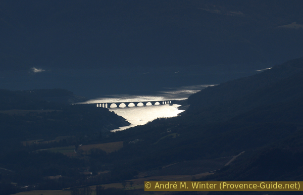
Old railway viaduct in the Lac de Serre Ponçon reservoir
After the section on the other side of the Faudon, the view opens onto the Gap basin. One mountain that looks tiny from here is the Chapeau de Napoléon (below in the photo). This table mountain is more impressive when viewed from the Vallée de la Luye.
No reproduction is permitted without the written consent of the author. (id3680)
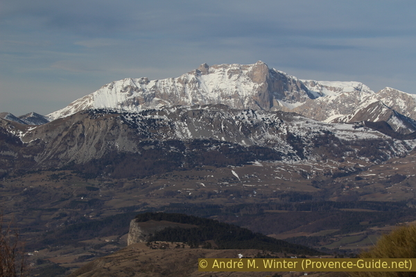
Mount Chapeau de Napoléon below and the higher Pic de Bure behind
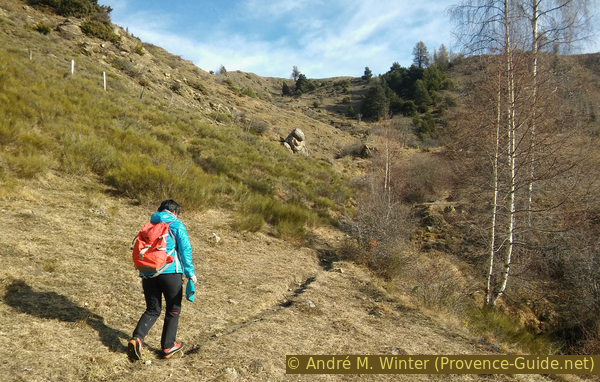
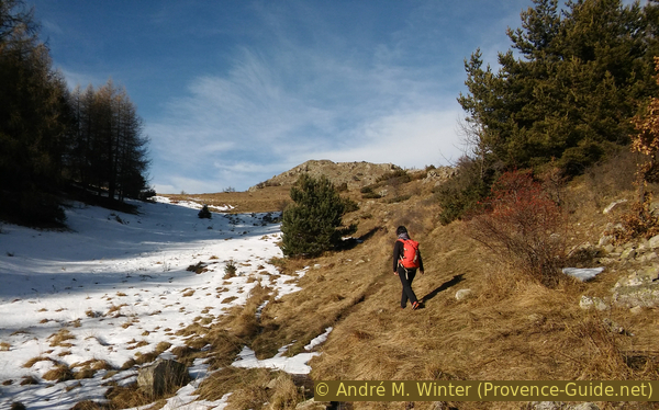
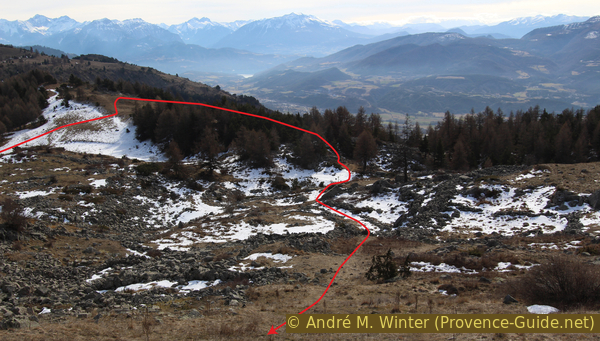
Finally we reach the Clôt Loubine, an alpine meadow that is gradually being reclaimed by the bushes. A torrent flows down from the Lac de Faudon in a hollow, this watercourse roughly shows us the direction that we have to follow uphill to the right.
No reproduction is permitted without the written consent of the author. (id3681)
Clôt Loubine alp
At the back: our destination Mount St. Philippe, the ridge around Lake Faudon and the ridge of Crête des Auréous.
The area and the entire slope are often wet, so it may be better to look for a path other than the marked one, which also goes uphill after crossing the creek.
No reproduction is permitted without the written consent of the author. (id3682)
Ascent to the Lac de Faudon
After a short time we reach the Lac de Faudon, which can easily be bypassed to the right (to the north). This lake is of glacial origin and is gradually silting up. In summer, it can dry out completely.
No reproduction is permitted without the written consent of the author. (id3683)
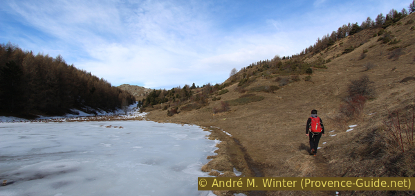
Path on the shore of the frozen Lac de Faudon
Section 2: Lac de Faudon - Croix Saint Philippe
➙ 1,2 km ... 20 min ➚ 100 m ➘ 10 m ↝ average
65% easy trails, with marks
20% hard-to-recognize trails, without marks
15% moderate trails, with marks
The clues
- Lac de Faudon lake, 1580 m
- Lac de Faudon source
- Ridge south of the lake, 1620 m
- Derelict village of Faudon, 1620 m
- East ridge of the Sommet Saint Philippe, 1670 m
- Saint Philippe summit, 1706 m
Summit ascent through the foundations of the ruined village on the south-east slope.
Exiting the lake on the western side, one passes a spring conspicuously lined with rectangular stones. If you look closer here, you will notice that they are covered with carvings of letters, numbers and symbols.
No reproduction is permitted without the written consent of the author. (id3684)
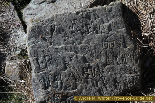
Carved stone at the source of Lac de Faudon
croix = cross
Coullon = (here) saddle
sommet = summit
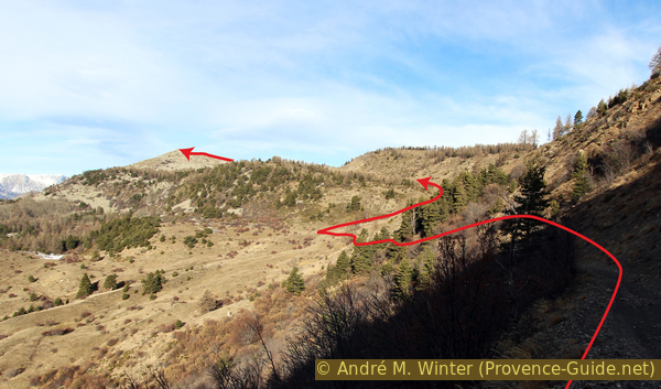
We follow the valley to the west to get to a reasonably flat meadow. The summit of St Philippe already appears in front of us, but we turn left to climb the gentle ridge to the south (the signpost indicates the Tour de Moissière).
No reproduction is permitted without the written consent of the author. (id3685)
On the trail north-west of the Lac de Faudon
On the flat ridge, we turn right towards the summit again. We pass a short wooded area and we go down a little towards the last trees.
No reproduction is permitted without the written consent of the author. (id3686)
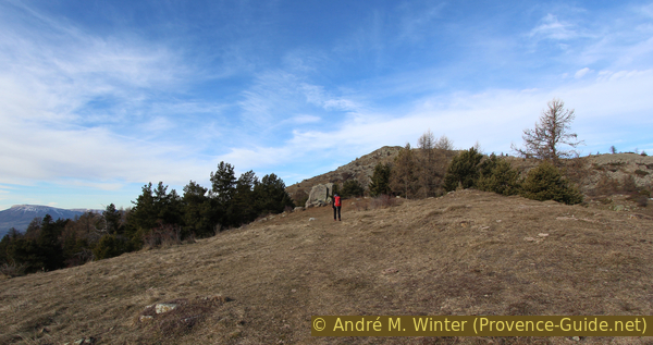
Flat ridge east of the Saint-Philippe summit
From there we are at the foot of the summit and at the same time at the foot of the village ruins. You don't notice the walls right away. All buildings and walls were built of unhewn stones in dry stone construction. Time and snow have gradually reduced the houses to a heap of stones. Walls used as fencing for pastures are still well preserved in the rock labyrinth. If you go up here, you can see the structures better. The excavations have brought objects to light that are more than 2500 years old, but without giving any information about the date of foundation or the reason for the choice of location.
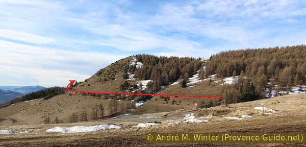
The photo also shows which path to follow: from the signpost, you don't go directly to the summit on the left, but to a flat stone slab in the middle of the ridge (and top middle of the photo). Between the rocks and stones, you first notice that there is a path that crosses the remains of the village.
We bypass the stone slab at the top on the right.
No reproduction is permitted without the written consent of the author. (id3687)
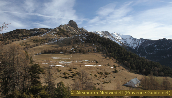
St. Philippe peak and the ruins of the village of Faudon
Structures can be seen better from above.
No reproduction is permitted without the written consent of the author. (id3688)
The ruined village of Faudon seen from above
At the top of the ridge, we turn left to reach the summit cross a little later. Beside the cross, we find the remains of a watchtower and concrete foundations.
No reproduction is permitted without the written consent of the author. (id3689)
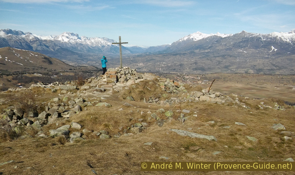
Saint Philippe summit cross
The view from the Saint-Philippe peak includes among others: the Gap basin and the Pic de Céüse, the Massif du Dévoluy, the Vallée du Drac and Champsaur, the Vieux Chaillol and the Sirac, Les Autanes, L'Aiguille from Moissiere and L'Arche.
No reproduction is permitted without the written consent of the author. (id3691)
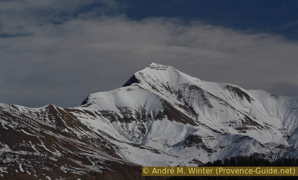
Grande Autane, 2781 metres
Section 3: St. Philippe - Auréous - Col de Moissière
➙ 2 km ... 30 min ➚ 30 m ➘ 130 m ↝ easy
20% moderate trails, with marks
30% easy trails, without marks
45% forest roads, few marks
The clues
- Saint Philippe summit, 1706 m
- Coullon du Château saddle, 1656 m
- South under the ridge of Crête des Auréous
- Collet des Auréous, 1643 m
- Col de Moissière pass, 1570 m
Descent without significant ascents and without getting too close to the ski area.
We go back over the ridge we came up and continue on it. After less than 10 minutes the ridge widens and is covered by forest. In front follows a difficult maze of rocks. So we go left past the trees and into the north side to reach a spot called Coullon du Château (signpost). What appears to be a meadow in a valley is a ski slope leading down from Mount Chatégré.
Here is one of the two areas where we touch the ski area, which is now only kept in operation with the help of snow cannons. We turn right and first go down towards Lac de Faudon.
No reproduction is permitted without the written consent of the author. (id3692)
The path bends to the left before Coullon du Château
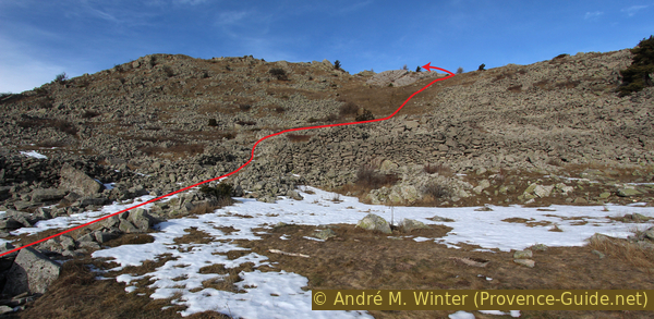
The descent from Coullon du Château is a little difficult. There is a fresh erosion zone on the left, we are descending just enough to avoid it below. Then we turn left and thread an unmarked path that follows the slope below the Crête des Auréous.
No reproduction is permitted without the written consent of the author. (id3693)
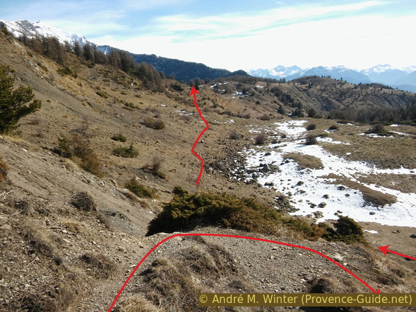
Erosion under the Coullon du Château
Further back our way to the east.
crête = crest
col = saddle
collet = saddle
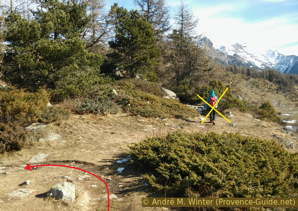
You should neither go down into the valley nor up the slope, we stay on the path that leads through the almost imperceptible Collet des Auréous saddle without any major detours and evenly.
No reproduction is permitted without the written consent of the author. (id3694)
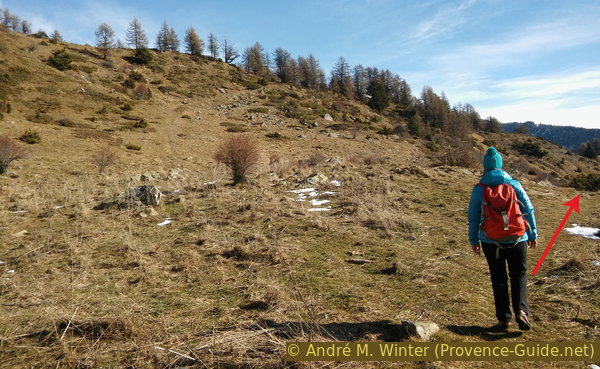
On the path under the Crête des Auréous ridge
Don't go up the ridge here yet.
Beyond the pass, we continue in the same direction. A forest road descends in hairpin bends towards the Col de Moissière pass, but we can follow the ski slope. It also leads us back into the flat pass and back to the starting point.
No reproduction is permitted without the written consent of the author. (id3695)
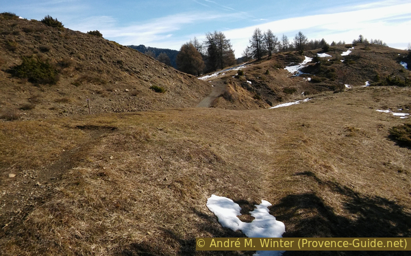
Path over the Collet des Auréous
Sources and additional information
It is better to use a good topographic hiking map: This tour is mainly on the IGN map "Champsaur, Vieux Chaillol, Parc National des Écrins", scale 1:25000, 3437OT. Only the southern part of the circumnavigation of the Faudon hill is missing (to found on the map "Gap, Montagne de Céüse", 3338ET).
If you don't want to bother with a paper map, you can also use mapping apps on your cell phone. On the one hand, it is the Cartes IGN app from the official map service. However, it requires access to the data network and this is sometimes difficult in canyons or remote locations.
Alternatively, you can use apps that store data directly on the device. They're generally not free, but they don't cost much. We mainly use OSMAnd, here it is possible to add contour lines, relief shading, markings and others. To store this data on your phone you need a lot of space.
Of course, one needs access to satellites for the GPS signal with any app. In some canyons this is not the case. Therefore, do not rely on the position shown, but read the map on your phone as you would read it on paper. Most apps are available for Android and iPhone. The applications usually allow us to record the route travelled and also view the GPS files offered for each of our hikes.
This page has been seen 1730 times since 20 March 2024.