Panoramic road over the saddle of Pontis
Natural and with walk site
35 min
view point
The Serre-Ponçon reservoir branches into several valleys. On the eastern flanks, a road with several vantage points runs south, west and north across the lake.
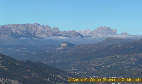
It is a narrow and difficult road far above the reservoir. As you climb and from the many bends you can see the mountainous area between Gap and Digne-les-Bains, the bare mountains of the Baronnies Provençales, the rugged Dévoluy massif, the hilly Champsaur and the towering Écrins massif. After passing through the small village of Pontis, we come to a picnic area with another viewpoint. From here you can also see the town of Embrun.
There is no public access to the route. Well-trained cyclists can also conquer the section by bike, the D7 is used by very few vehicles. In this case it is advisable to drive from north to south, the ascent is therefore less steep and much better shaded.
No reproduction is permitted without the written consent of the author. (id1470)
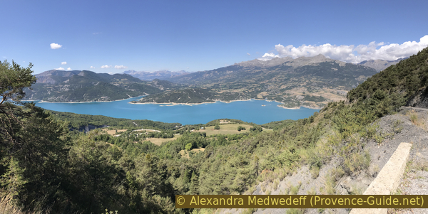
View of the Lac de Serre-Ponçon
Access by car
In the east of the lake, the main road D954 runs from Barcelonnette via Le Sauze-du-Lac to Savines-le-Lac. Our D7 scenic road runs high above in the municipality of Pontis.
The southern section of our route leads over very narrow, steep and short hairpin bends. Incidentally, vehicles over 8 meters in length are not allowed to drive here and we strongly advise campers and especially drivers with caravans not to drive on this route! We also recommend approaching the route from the south, so you have the difficult section at the beginning. So we have to start at the south-east branch of the reservoir.
Coming from Briançon or Embrun, you drive through Savines-le-Lac and stay on this side of the lake, so without going over the long bridge. Coming from Gap, head towards Savines-le-Lac and after the bridge, turn right towards Sauze-du-Lac. Coming from the north, you pass the entrance to Les Granges campsite and, in the following left turn, the D7 climbs up to the village of Pontis. If you want to do the tour from north to south, you drive up here.
However, we recommend starting in the south, so you drive to and through Le Sauze-du-Lac and on towards Barcelonnette. After a bridge and two rocky bays, a remarkably straight section follows and immediately after a high retaining wall made of regular stone blocks, a road sign points to Pontis. If you pass a modern chapel, you've gone too far.
Coming from Barcelonnette or Digne-les-Bains, follow the road to Lac de Serre-Ponçon and Savines-le-Lac. After the one-lane tunnel follows a chapel and a cemetery. Immediately after a bridge, the road to Pontis branches off to the right.
The tight hairpin bends begin very quickly. The person behind the wheel will be very busy, but there are several options to stop and enjoy the view. Here you can see the black shore of the reservoir. Fort Joubert looms further to the left and the valley of Ubaye can be seen on the far left.
After a dozen hairpin bends you can also see a little further west and the crest of the dam wall.
Here follows a short section without hairpin bends, but it remains steep throughout. Wild sea buckthorn grows next to the road. The leaves resemble those of the white willow, but the branches of the bush hide long and strong spines. At the end of summer and into autumn, the small, striking orange fruits ripen. They sit right on the trunk and near the evil thorns, making picking very difficult. The fruits are very acidic, but they make good jams and juices that you can buy in local shops.
The road then dives into a forest, but the slope crossed gets steeper and steeper. In places the road is concreted into the slope, from these places you also have a good view over the central section of the lake. One should stop here to admire the striking mountain backdrop of the Baronnies and Dévoluy.
No reproduction is permitted without the written consent of the author. (id161)
Chapeau de Napoléon
Napoléon's Hut
After the first section with hairpin bends, we reach 1000 meters above sea level, but the road continues to climb. Another series of hairpin bends then begins. If you look to the west you can see fields with solar panels, from afar they could be mistaken for blooming fields of lavender.
When the level of the lake is low, you can see the Viaduc de Chanteloube, a railway link that was never used.
No reproduction is permitted without the written consent of the author. (id2141)
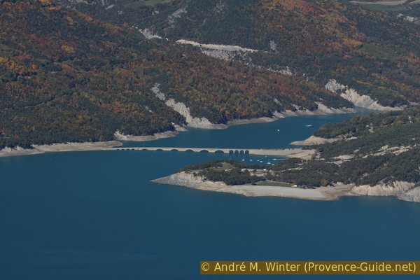
Viaduc de Chanteloube above the water surface
We pass the hamlet of Adroit de Pontis and the road crosses poor fields. A little later you come to the less distinctive saddle Col de Pontis at 1300 meters above sea level.
No reproduction is permitted without the written consent of the author. (id2142)
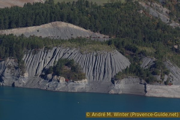
Erosion on the shores of Lac de Serre-Ponçon
We reach the village of Pontis along the following road. Here you can visit the Saint-Jérôme church and the school museum. Otherwise there is no shop or rest stop here. However, you can rent holiday apartments.
After Pontis we continue downhill and we cross a remarkably high and dense forest. A small torrent runs into the valley, this water supply explains the large trees.
No reproduction is permitted without the written consent of the author. (id806)
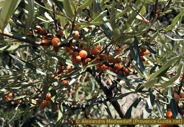
Ripe fruits on a sea buckthorn branch
On the descent to the north there is only one hairpin bend, but you should stop here as well. Firstly, there are picnic tables to rest after a not inconsiderably strenuous drive. When driving off the road to the parking lot, you have to pay attention to the threshold created by the slope of the road.
Secondly, there is another vantage point over the northern part of the lake to the Écrins massif, the Savines bridge and Embrun.
If you go ahead a bit, you can also see the Saint-Michel chapel on a small island in the lake on the left. It was supposed to be destroyed and submerged in the waters of the reservoir, but it is just above the maximum level and has thus been preserved. However, it is walled up to stabilize it. It is one of the most photographed motifs on the Lac de Serre-Ponçon.
A little further down you reach the D954 road, which circles the lake here. To the right you quickly come to Savines-le-Lac, to the left you go back to Barcelonnette or Digne.
No reproduction is permitted without the written consent of the author. (id2116)
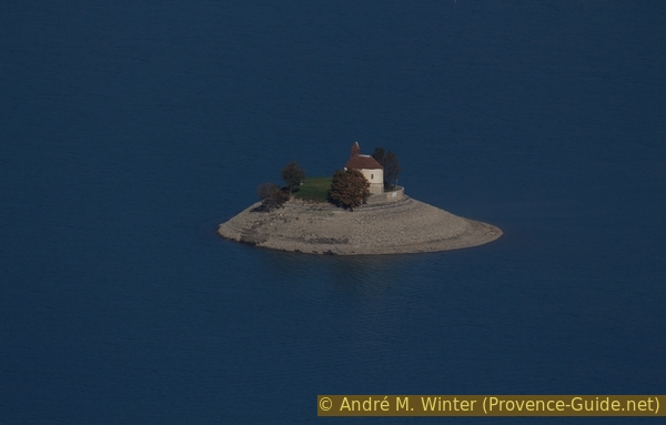
Saint-Michel chapel in the Lac de Serre-Ponçon
No reproduction is permitted without the written consent of the author. (id2132)
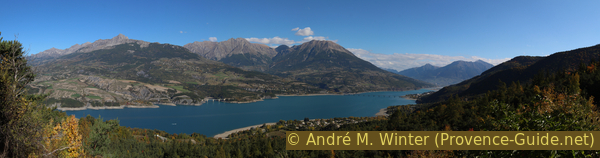
Panorama over the north of the lake of Serre-Ponçon