Combe de Curnier gorge
Through a dry and narrow little canyon at the foot of Mont Ventoux
hike
easy
1 h 45 min
far
yes
no
mountain
Introduction
There are a multitude of gorges at the foot of Mont Ventoux, which shows that the region was not always as dry. But only the Combe de Curnier is so tight that you hit the sides with both shoulders at the same time. It is a short hike that anyone can do and gives the impression that you are not in Provence at all. In the gorge you can find freshness and shade in the middle of summer. However, it's also exciting to come to the area at the end of March when the cherry trees are in full bloom. Large areas with cherry trees can be found directly at the foot of the mountain and thus near the start of this hike.
The gorge also served as a shelter for the shepherds, some caves are closed with dry stone walls. However, there is no evidence of settlement in the gorge, either in the Middle Ages or in prehistoric times.
Monday morning you can stock up on provisions at the market in Bédoin.
The facts
3,6 km total distance
1 h 45 min walk time
250 m total elevation
orientation easy in nature
mark 60% of the total distance
55% in the riverbed
45% forest roads
dangers avoid by of thunderstorms, snow and icy paths in winter
children yes
useful picnic stuff
required hiking boots, hiking equipment and water
GPS coordinates (WGS84) of start and end point 44.132796,5.21445
downloads ![]()
![]()
No reproduction is permitted without the written consent of the author. (id3150)
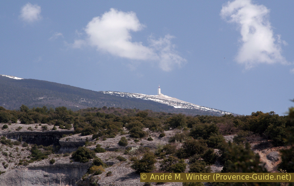
The Mont Ventoux above the Combe Curnier
In April you can still see snow on the summit. The hike runs in the gorge at the bottom right.
Public transport
Access by public transport to the starting point of the tour is not easy. There is a train from Avignon to Carpentras about every 30 minutes, look under TER PACA (only french), this is the terminus of the line. Right at the exit of the train station is the bus station, this is where the buses from Trans'CoVe (only french) depart from. Line L takes you to Bédoin. Be careful, there are special courses for students from Bédoin to Carpentras, but there is no course from Carpentras to Bédoin around noon, for example. Get off at the Centre station and cross the city centre from south to north, preferably through small alleys.
arrêt = bus stop
At the roundabout, continue onto Route de Crillon le Brave (arrow) but take an immediate right onto Rue des Époux Tramier. At the crossing with the large plane tree (Place de la Bourgade), turn left: follow Rue de la Calade, then continue along Rue du Four Neuf to the Église Saint-Pierre. Continue north and go down the Traverse Saint-Pierre. At the bottom turn left (Rue de la Coste Froide) and at the end turn right (Rue du Vieil Hôpital). We come to a roundabout with an olive tree in the middle.
A small lane continues north (a little to the right of the roundabout), we take the Chemin de la Ferraille, which first makes a big curve to the right, then at a right angle to the left and another curve to the right. We arrive on the Chemin de la Montagne. After 2,5 km the road enters a low forest with a sign on the left, no entry, keep to the right. Now go past the last houses and enter the gorge from below to start the tour described here (signpost). 4 km and 180 vertical meters for one direction.
This access from Bédoin is also included in the GPX-file available on this page. It is shown in red on the map.
Access by car
The tour is located between Carpentras and Mont Ventoux. The D974 road leads from Carpentras to Bédoin, then continue towards Flassan. There are two options here:
- Continue on the Route de la Montagne at the town exit. You see a parking lot at the right and turn then to the left. Follow this road (signs for the Chambre d'hôtes de Curnier). After 2.5 km the road leads into a grove with a sign on the left that says no entry. It's time to look for a parking space here. Continue on foot straight past the Les Colombets farm.
- Continue on the D974 road, first towards Flassan, but then to Chalet Reynard and Mont Ventoux. After another kilometre, turn left towards Les Baux and Les Fébriers. Drive past right the hamlet of Les Baux, continue into the cul-de-sac, on the asphalt road through the houses of Les Fébriers and look for a car park in the forest. Walk west (left) on the GR91 long-distance hiking trail to the entrance to the gorge (hiking signpost).
Useful parking spaces
More or less wild parking spaces at the foot of Mont Ventoux near the starting point of the tour, see above under access by car.
Hints
The ascent through the gorge is shaded most of the time. On the other hand, the descent is in full sun, south-facing and on a stony forest road. You should be prepared and go back without a break.
Warning: the gorge can fill with water during and after thunderstorms. Given the narrowness and sheer cliffs this would be a deadly trap so it's essential to keep an eye on the weather forecast, Mont Ventoux can act as a barrier against the clouds and thus receive more rain than other places in the Vaucluse. Here we are in the limestone zone, the rain is beating against the northern slopes, but can flow off in the south and thus also affect this gorge. This is very rarely the case, but one should still be careful.
The whole region is a zone with a high risk of forest fires. In summer, but also in other seasons when it is very dry or by strong winds, access to the forest areas can be regulated. As a result, the roads may be closed to traffic and/or the trails prohibited to hikers. Current information: Map for access to the forests of the Vaucluse department (only french). The map shows the colours green, yellow, orange and red which correspond to levels of danger.
No reproduction is permitted without the written consent of the author. (id3149)
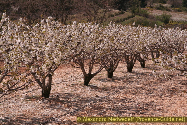
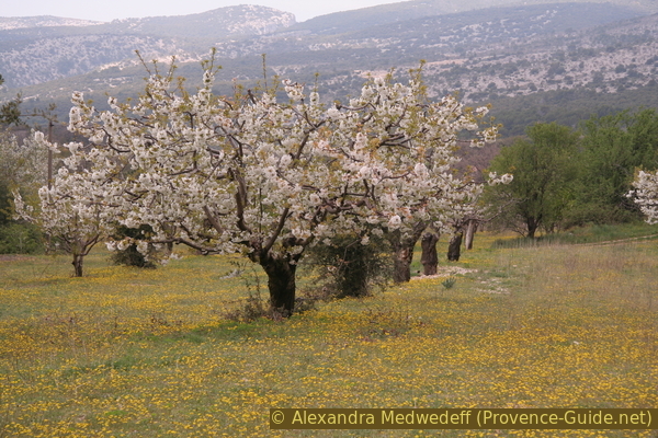
Cherry trees at the foot of Mont Ventoux
The photo was taken in April.
The sections
- Go up the valley floor in the canyon
- Descent on the ridge to the east and at the foot of the massif back to the starting point
Section 1: Combe de Curnier
➙ 2 km ... 1 h ➚ 250 m ➘ 0 m ↝ easy
100% in the riverbed, few marks
The clues
- Les Colombets, 440 m
- Combe de Curnier
- Exit via a crossing forest road, 690 m
Climb up through the gorge.
GR = long hiking trail
It is easy to locate the lower exit of the gorge, regardless of which approach you have chosen. For the first few meters, the former course of the river forms a natural path.
In places you can see the old ceramic aqueducts that were used to channel water from a non-permanent spring out of a meander of the Combe de Curnier.
It is enough to go up this wide path, it narrows here and there.
No reproduction is permitted without the written consent of the author. (id3151)
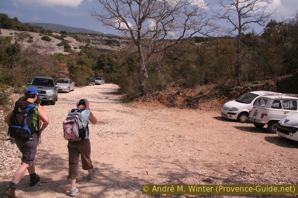
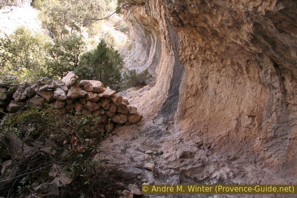
Lower end of the Combe de Curnier canyon
There are other car parks, here the gorge exit is defaced.
Gradually the cliffs of the gorge come closer, in them you can still see the traces of old watercourses. Several rock overhangs hang one on top of the other, overlapping. The rock is crumbly, large heaps of scree come down from some transverse valleys. These are the last chances to get out of the bottom of the gorge. A little further ahead there is no other option but to go forward or turn around.
No reproduction is permitted without the written consent of the author. (id3152)
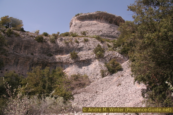
Canyon walls with overlying washouts
Traces of human use of the gorge can be found several times. They are mainly rough walls of rough stone, forming enclosures under the great overhangs at the level of the dry river bed.
No reproduction is permitted without the written consent of the author. (id3153)
Old cattle pen under an overhang in Combe Curnier
At the bottom of the gorge grows some shrubs, sometimes forming dense walls of vegetation. But the way stays free.
There is no developed path here, you hike directly in the creek bed. However, there is no passage with a particular slope or difficulty, you don't have to climb anywhere.
No reproduction is permitted without the written consent of the author. (id3154)
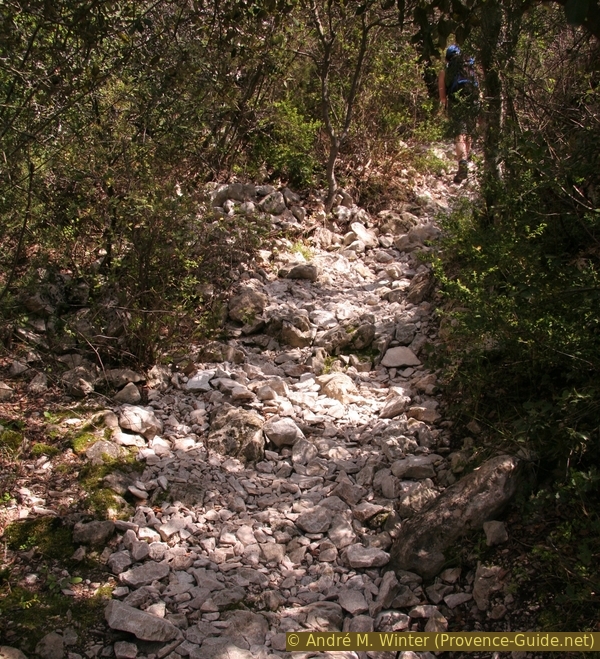
Shrubs at the bottom of the Combe de Curnier
During the ascent you finally walk in the meanders, which get narrower and narrower in the gorge. You make a series of turns to the left and right, ending up with almost losing your bearings. But it is impossible to get lost, there is no possible exit on the side walls. The only constant is the regular gradient. Only rarely do boulders form small steps, as shown in the photo.
The cliffs come closer and closer and remain narrow for a long distance. At times, the width between the two rock walls even drops below one metre. The vegetation on the steps above also darkens the scene.
No reproduction is permitted without the written consent of the author. (id3155)
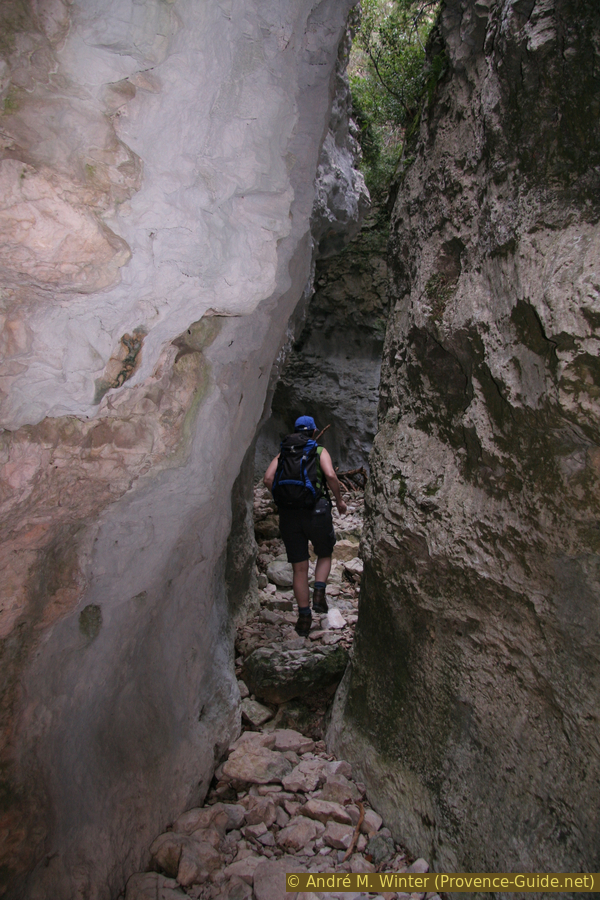
Hike in the narrow canyon Combe de Curnier
We walk on the stones that form the dry river bed. However, this river bed does not correspond to the deepest point dug by the watercourse in the rock. Therefore, we bypass previously formed scours on different levels.
It is still a particularly narrow stretch, even if the gorge is not particularly deep here.
No reproduction is permitted without the written consent of the author. (id3156)
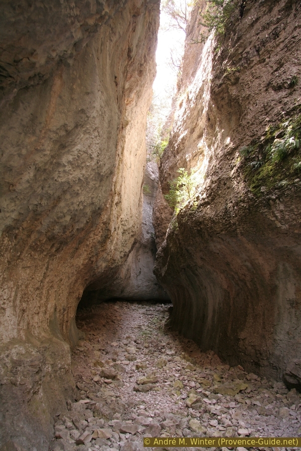
Combe de Curnier wider down here
The sun does not reach the bottom of the gorge, so mosses and lichens can grow here, which would otherwise have no chance of surviving a few meters higher on the slopes of Mont Ventoux and exposed to the south.
No reproduction is permitted without the written consent of the author. (id3157)
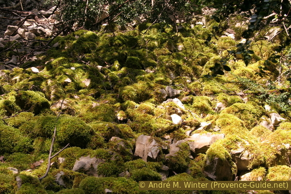
Moss pads on the scree
partie supérieure = upper part
vallon = valley
After a few narrow meanders and after leaving the Combe de Bouisse on the left (at 660 m), the gorge becomes less prominent and greener. Without being perceptible when hiking, it turns towards the north-east on the second half.
At about 690 meters above sea level, the gorge is so shallow that a forest road can easily cross it horizontally. This is the moment for us to leave the dry river bed right. The photograph taken at this point shows the view back towards the upper section of the Combe de Curnier.
No reproduction is permitted without the written consent of the author. (id3158)
Combe de Curnier seen from above
Section 2: Coste d'Antoni
➙ 1,6 km ... 40 min ➚ 0 m ➘ 250 m ↝ easy
85% forest roads, without marks
15% forest roads, with marks
The clues
- Forest road at the top of the Combe de Curnier, 690 m
- Descending the ridge east of Combe de Curnier
- Back to Les Colombets, 440 m
Descent in full sun.
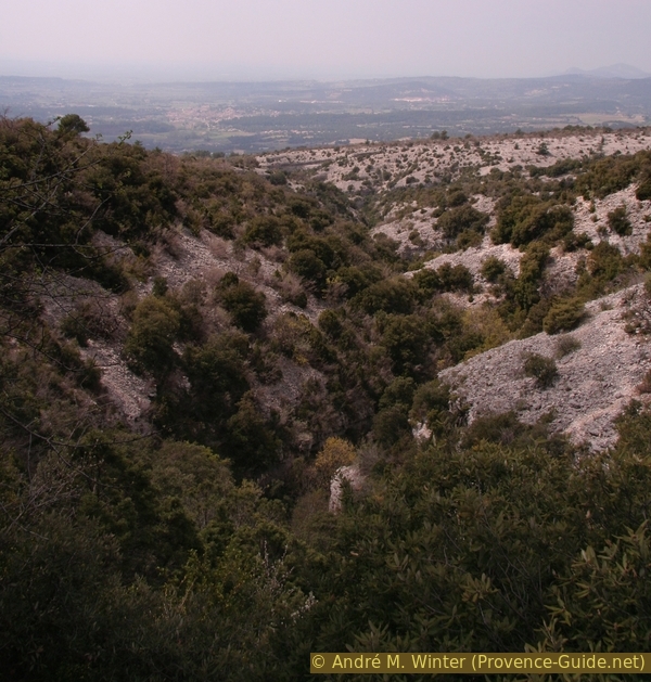
The 690 meters of altitude remain the highest point of the tour, as we walk horizontally to the right out of the gorge. At the next crossroads we continue downhill on a rocky path (no special marking).
In some places we have the opportunity to see Bédoin and the Combe de Curnier.
No reproduction is permitted without the written consent of the author. (id3159)
Bédoin and in front the Combe de Curnier gorge
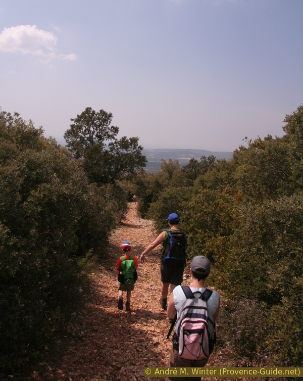
Gradually the path widens and the scree becomes a little finer. In this way we go downhill quite quickly 250 meters. The ridge is not very inviting, the bushes are too squat to provide shade. It is better to go through this section quickly in one go, there are larger trees further down to take a break or even a picnic before finally returning to the starting point.
No reproduction is permitted without the written consent of the author. (id3160)
Gravel path downhill east of the Combe de Curnier
GR = long distance trail
Once at the bottom, we turn right to return in less than 200 meters to the starting point at the bottom of the gorge.
Those coming from Fébriers turn left to reach this settlement in less than 800 meters.
No reproduction is permitted without the written consent of the author. (id3161)
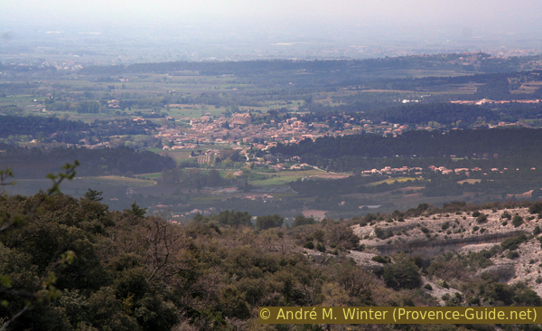
Blossoming cherry trees and meadows
Sources and additional information
It is better to use a good topographical hiking map: this tour is on the IGN "Mont Ventoux" map, scale 1:25000, 3140ET.
If you don't want to bother with a paper map, you can also use mapping apps on your cell phone. On the one hand, it is the Cartes IGN app from the official map service. However, it requires access to the data network and this is sometimes difficult in canyons or remote locations.
Alternatively, you can use apps that store data directly on the device. They're generally not free, but they don't cost much. We mainly use OSMAnd, here it is possible to add contour lines, relief shading, markings and others. To store this data on your phone you need a lot of space.
Of course, one needs access to satellites for the GPS signal with any app. In some canyons this is not the case. Therefore, do not rely on the position shown, but read the map on your phone as you would read it on paper. Most apps are available for Android and iPhone. The applications usually allow us to record the route travelled and also view the GPS files offered for each of our hikes.
This page has been seen 2437 times since 20 March 2024.