Corniche des Maures the Fenouillet valley
A hike along the natural coastline of Cavalaire
hike
easy
2 h 30 min
yes
yes
no
walk
Introduction
The Domaine Foncin estate is at the heart of Cavalaire's unspoilt coast. It is owned by the Conservatoire du Littoral, which is the non-profit organization that also maintains the coastal footpaths. It is therefore an important green corridor, which at least here prevents the coast from being concreted. The area is called the Corniche des Maures, which already indicates the steep coast. The Massif des Maures is the mountain range between Hyères and Saint-Raphaël. The path laid out here always leads high above the water, so you also have a good view. The way back is completely different: it goes back to the starting point through a wet valley, which is very rare here.
The land ownership goes back to Pierre Foncin (1841-1816). He was a geography professor and textbook author. He got here in 1890 on the newly built railway. The train route was closed after World War II, we will cover a bit of it on foot. Pierre Foncin was very committed to the region and passed this love on to his daughters. The last heiress bequeathed the estate to the Conservatoire du Littoral in 1977. It was the first donation to this organisation, which was founded just two years earlier and is now protecting large areas across France.
The facts
5,4 km total distance
2 h 30 min walk time
170 m total elevation
orientation average
mark 60% of the total distance
55% easy trails
25% hard-surfaced quiet side streets
10% hard-surfaced paths
5% on beach
5% forest roads
dangers slippery sections in winter
children yes
useful picnic stuff, swimming gear
required trekking shoes, hiking gear and water
GPS coordinates (WGS84) of start and end point 43.166983,6.520579
downloads ![]()
![]()
Public transport
Bonporteau beach can be reached by bus line 878 on Zou! (only french). It runs around 20 times a day between St. Tropez and Toulon. Line 873 runs four times between Aéroport d'Hyères Airport and St. Tropez. We get off at the Bonporteau stop. From here we head briefly west (avoiding the roundabout) and down the first lane on the left towards the beach.
Access by car and parking possibilities
Coming from the A8 motorway, first drive in the direction of Saint-Tropez. From the very large roundabout near Port-Grimaud, continue towards Cavalaire. We cross the village of La Croix-Valmer and in Cavalaire we follow the direction of Le Lavandou. At the city exit we pass a last roundabout with large palm trees in the middle. We are now above the Plage de Bonporteau beach and at the starting point. If you find a parking space here, use it.
In the high season, the few places are usually occupied early. In this case, continue towards Le Lavandou and take the first left towards Hameau du Dattier (dead end sign). After 100 meters you are at the beginning of the second section of the tour, including a few parking spaces. If it's full here too, you can continue down the narrow road and you'll find what you're looking for after 300 meters at the latest.
Coming from Hyères and Le Lavandou, head towards Cavalaire. Before you know you're in town, you'll pass the Menuiserie Navarro shop. Then we turn right at the first opportunity towards Hameau du Dattier (dead end sign). See the further description in the paragraph above. Only in the absolute low season can you drive up to the Bonporteau bus stop and hope for a parking space there.
No reproduction is permitted without the written consent of the author. (id5211)
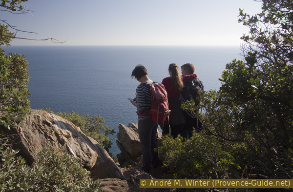
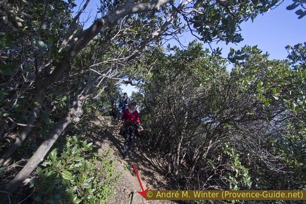
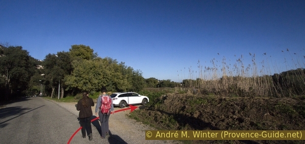
Hikers on the Corniche des Maures
No reproduction is permitted without the written consent of the author. (id5236)
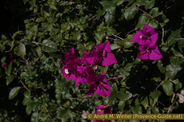
Bougainvillier in Le Dattier
Hints
This hike is quite short and yet has two very different sections. First it is hilly and with frequent views of the sea. The second part runs in a dark valley surrounded by giant reeds.
You can shorten the tour and still experience both aspects.
The whole region is a zone with a high risk of forest fires. In summer, but also in other seasons when it is very dry or by strong winds, access to the forest areas can be regulated. As a result, the roads may be closed to traffic and/or the trails prohibited to hikers. Current information: Map of access to the forests of the Var (also english). The map shows the colours green, yellow, orange and red which correspond to levels of danger. The affected area is: Corniche des Maures (4).
The sections
- Plage de Bonporteau - Le Dattier - Tunnel: the classic coastal hike high above the sea with a view of the islands. At the end we walk on the former railway line
- Vallon du Fenouillet - Bonporteau: a creek with irregular water flow and overflowing vegetation accompanies us on the way back
Section 1: Plage de Bonporteau - Le Dattier - Tunnel
➙ 3,7 km ... 2 h ➚ 140 m ➘ 120 m ↝ easy
5% hard-surfaced paths, few marks
5% forest roads, few marks
40% easy trails, few marks
10% easy trails, without marks
35% hard-surfaced quiet side streets, without marks
The clues
- Bonporteau bus stop, 20 m
- Plage de Bonporteau beach, 0 m
- La Nasque, 110 m
- Hamlet Le Dattier, 70 m
- railway tunnel, 65 m
After the descent to the beach, the ascent to the coastal hills begins immediately. However, we will come back to this Plage de Bonporteau beach at the end of the tour.
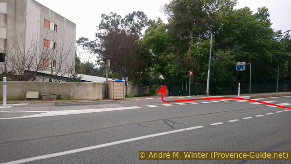
At the exit of Cavalaire, on the road to Le Lavandou and after the last roundabout, there are unsightly buildings facing the sea that do not contribute to the fame of the town of Cavalaire. The bus stop is also located here. To the right of the last building, a path leads down to Plage de Bonporteau.
No reproduction is permitted without the written consent of the author. (id5212)
Path to Plage de Bonporteau beach
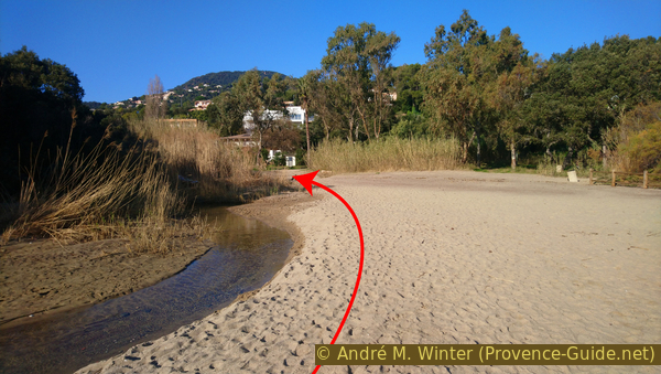
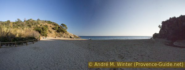
We quickly enter a more natural landscape and down below, next to the mouth of the Ruisseau du Fenouillet stream, we come to Bonporteau beach. You can hardly see any houses from here.
No reproduction is permitted without the written consent of the author. (id5213)
Mouth of the Ruisseau de Fenouillet on Bonporteau beach
However, we don't have to turn onto the beach but turn right in front of it. If you did go to the water, turn back and keep to the left.
No reproduction is permitted without the written consent of the author. (id5214)
Looking back from the Plage de Bonporteau beach
We now have a curious colonial-style building on the right-hand side. However, the terraces and the large pillars are made of wood. Today this is a hotel and at the same time proof that it was and is always possible to build with style.
No reproduction is permitted without the written consent of the author. (id5215)
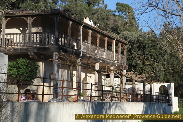
Le Clos des Sept Palmiers
A few meters further and between the long poles of giant reeds is a bridge and a signpost that says "Par vue mer". This is not a location and just means "by overlooking the sea". This can only be explained if you know that there are several parallel paths.
We also climb up this forest road to the first hairpin bend and a first vantage point.
No reproduction is permitted without the written consent of the author. (id5216)
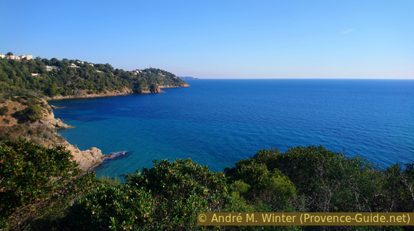
Bay of Bonporteau and Cap de la Vigie
From the lookout we return to the forest road, but we immediately turn left again. Here, too, there is a signpost with the note "Par vue mer". This path is narrow and leads through the typical Mediterranean vegetation. If you are on a passable forest road, you have gone too far./p>
No reproduction is permitted without the written consent of the author. (id5217)
Seaside way
The path remains in this form up to the hamlet of Le Dattier. For almost 700 meters it is accompanied by a forest road that goes a few meters further inland. It can be reached several times via short connecting routes.
Just after about 700 meters there is the possibility to shorten the round by more than half. The narrow path turns right and leads to a junction where our normal tour continues to the left. If you turn right here and then immediately left on a forest road, you will be led straight into the valley of the Fenouillet stream. You come to the first footbridge in section 2.
The vegetation is quite dense, but rocks always allow natural vantage points. In any case, the coast remains steep throughout.
No reproduction is permitted without the written consent of the author. (id5218)
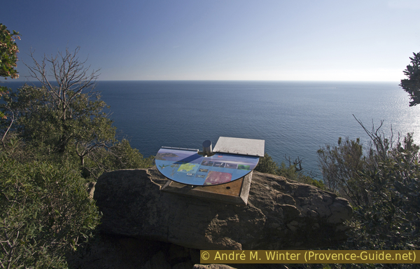
Information with view of the sea
The path always leads uphill, even if there are short passages downhill. You can also see the rise in the panorama: the Bay of Cavalaire suddenly becomes visible.
No reproduction is permitted without the written consent of the author. (id5219)
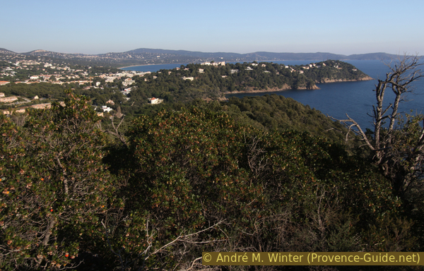
Cap de la Vigie and Bay of Cavalaire
There are hardly any crossroads and we keep to the left throughout without descending to the sea.
After about 50 minutes of walking we reach an altitude of about 100 meters above sea level and stay there as long as we go west.
When the path begins to descend again and when the trees are less dense, you can head to the White House built by Pierre Foncin in 1894. The building is open on the Journées du patrimoine (European Heritage Days) in September and should be accessible more often in connection with the nature eduction house "L'Usine" (which we'll get to later).
No reproduction is permitted without the written consent of the author. (id5220)
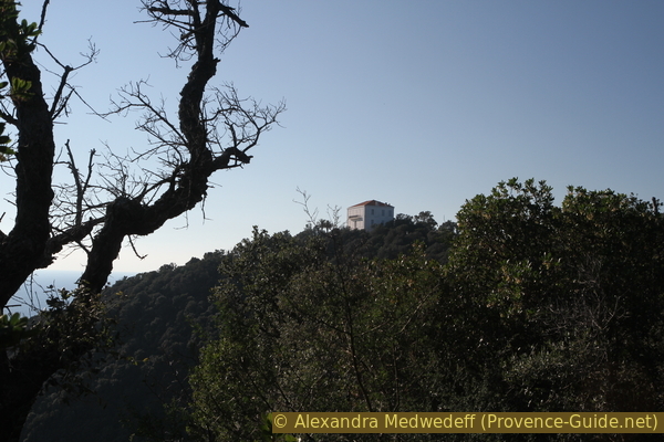
The White House of Domaine Foncin
Our path continues in the same direction and leads to a crossroads on La Nasque with a wayside shrine. We keep left and from now on it goes downhill.
On the right you can ascend to the White House. But the building is mostly closed and you don't get a better view from the top than from the path.
No reproduction is permitted without the written consent of the author. (id5221)
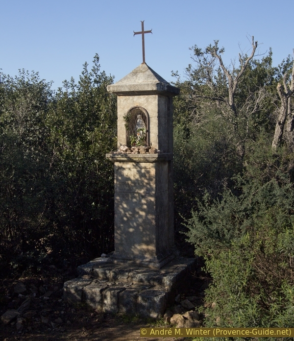
Shrine at La Nasque
The path is now steeper and bumpier. We circum-hike the hill on which the White House stands.
No reproduction is permitted without the written consent of the author. (id5222)
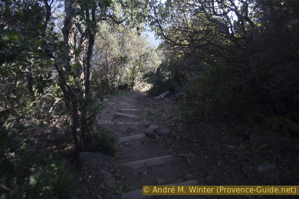
Steps on the way under the White House
By turning the path to the left, we also get a better look back.
We pass above two rocky coves located east of Cape Pointe du Dattier.
No reproduction is permitted without the written consent of the author. (id5223)
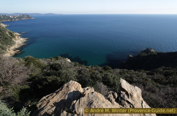
Cap Cavalaire and Cap Lardier in retrospect
In the axis of the cape we come to another crossroads. The marked trail leads to the right and stays higher. However, we continue down to the left. This is how we get through the hamlet of Le Dattier and not just circle it.
At the same time we turn progressively to the right. The descent ends when the path leads to a former forest road. A path leads to the cape on the left, but without reaching the water.
So this time we go to the right and soon see a few houses ahead.
No reproduction is permitted without the written consent of the author. (id5224)
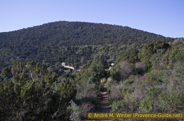
Direct route to Le Dattier
Le Dattier originally consisted of just a few fishermen's cottages by the sea. The houses higher up were built in connection with the railway construction. Today it is no longer allowed to build here, but some old houses have been turned into summer villas.
No reproduction is permitted without the written consent of the author. (id5225)
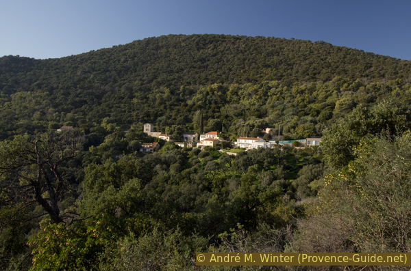
Hamlet of Le Dattier
The path widens at the first houses and in the following alley you think you are in a real village.
No reproduction is permitted without the written consent of the author. (id5226)
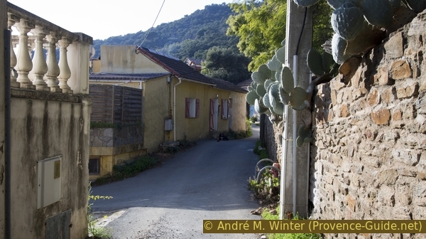
Alley in the hamlet of Le Dattier
At the only intersection worth mentioning, we keep sharply to the right. The straight road on which we are now standing is the former railway line. We proceed on the paved part. We quickly come to a dark incision and a tunnel portal. The tunnel is around 200 meters long, dead straight and illuminated. We now go through and need not fear traffic, only the residents of Le Dattier are allowed to enter.
No reproduction is permitted without the written consent of the author. (id5227)
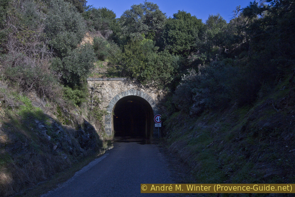
West portal of the former railway tunnel
Pierre Foncin settled here because he could travel by train. However, the route between Saint-Tropez and Hyères was always problematic. It was the last section in the wide-meshed network of the Chemin de Fer de Provence. The builders had underestimated the frequent debris flows and also undersized the structures. At that time and for a long time afterwards, the railways in France were privately owned. Since the railway company was always on the verge of bankruptcy, the the state was asked to help with the electrification of the route in question. But the request is rejected with the argument that the railway company could slip into the profit zone as a result! More landslides, which are expensive to remediate, follow, the fighting during the Allied landings in 1944 devastated parts of the rails and a major fire in the depot in Fréjus in 1948 put an end to the railway line.
Since then, the route has mainly been used as a road, less often as a cycle path. However, it would be very difficult to lay rails again, because many road crossings only became possible when the route was freed. If Pierre Foncin had known how heavy motor traffic would be on the D559 road (St. Raphael, Cavalaire, Hyères), he would certainly not have bought the land here. It can even be seen as a mockery that the former railway line on this section is called Chemin Pierre Foncin.
No reproduction is permitted without the written consent of the author. (id5228)
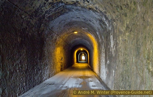
Inside the old railway tunnel
At the north portal of the tunnel we of course continue straight ahead. Slowly we come out of the deep artificial neckline.
We pass the access to the nature house "L'Usine". This is where what Pierre Foncin's heiress demanded when she made the donation is being implemented: not only protecting nature, but also teaching people about it. It took over 40 years you complete.
However, we are going further.
No reproduction is permitted without the written consent of the author. (id5237)
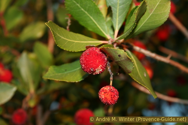
Ripe fruit on a strawberry tree
Section 2: Sentier du Fenouillet - Bonporteau
➙ 1,7 km ... 30 min ➚ 30 m ➘ 50 m ↝ easy
65% easy trails, few marks
20% on beach, without marks
15% hard-surfaced paths, few marks
The clues
- Western access to the Fenouillet valley, 45 m
- Plage de Bonporteau beach, 0 m
- Bonporteau bus stop, 20 m
We go through a surprising natural tunnel made of plants.
500 meters after the railway tunnel, we come to the entrance to the Sentier du Fenouillet path. The large and wild former parking lot has been cleared and a mound of earth limits parking to a few spaces. Attention, several pits have been dug behind the wall, which are apparently intended to prevent all-wheel drive vehicles from being up to mischief here.
No reproduction is permitted without the written consent of the author. (id5229)
Access to the Sentier du Fenouillet path
We come to an open field, it is the former parking lot. The path is clearly visible, at the end of the field it turns right and leads into a first thicket of large reeds. So we come to the valley of a tributary to the Fenouillet. A boardwalk makes crossing easier.
The other way down is the shortcut mentioned above.
No reproduction is permitted without the written consent of the author. (id5230)
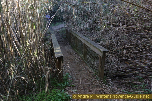
First footbridge under giant reeds
This giant reed is also known as the Canne de Provence. It is well adapted to the area because it tolerates drought and a relatively high salinity in the soil. So it withstands the long summer months where the creek is dry and you can also find it near the beach. The rugged relief here limits its spread, but elsewhere the plant ranks among the most damaging invasive species.
No reproduction is permitted without the written consent of the author. (id5231)
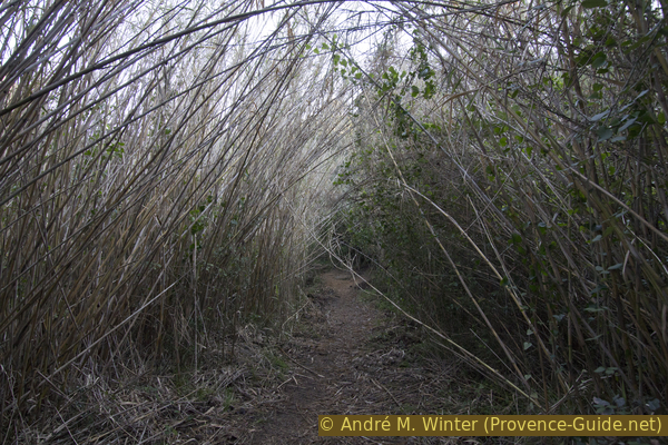
Pile reed in the valley of the Fenouillet creek
The reeds and the remaining overflowing vegetation thwart any attempt at orientation. However, the path is well trodden. We now cross the Ruisseau du Fenouillet on a second footbridge.
No reproduction is permitted without the written consent of the author. (id5232)
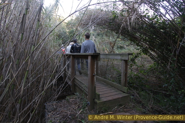
Second footbridge in the Fenouillet valley
Briefly we are located on the left and on the north bank. But we quickly come across a ford to the other side. Large stones help with crossing. The creek rarely carries much water and it is usually dry, the catchment area is not particularly large. However, during or after a thunderstorm, you won't get through here dry-shod.
Another ford follows after 200 meters. The path becomes wider again.
No reproduction is permitted without the written consent of the author. (id5233)
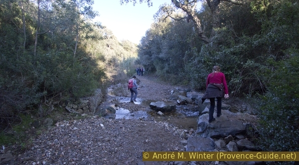
Second ford on the Fenouillet creek
In the valley, the vegetation is mostly given free rein, the former forest road is not always recognizable as such. So we come to a third ford.
No reproduction is permitted without the written consent of the author. (id5234)
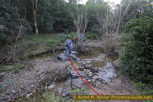
Third ford on the way
Further ahead we can see the first section of the ascent, including the hotel with the wooden pillars.
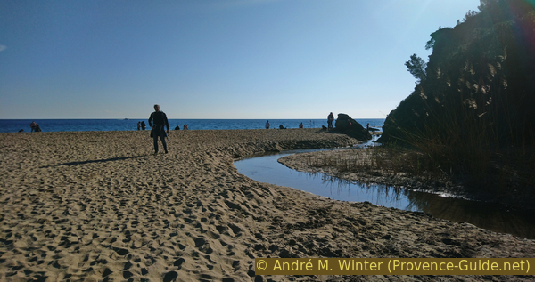
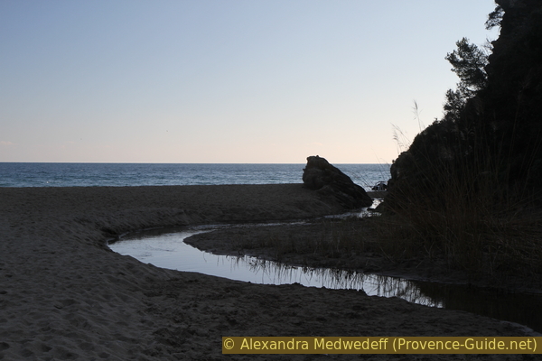
So we are back at Plage de Bonporteau and it probably depends on the season if the beach is full or empty. The photo was taken at the end of the afternoon on January 1st, 2020 and some residents were here to enjoy the last rays of the sun in a Covid-free world..
No reproduction is permitted without the written consent of the author. (id5235)
Plage de Bonporteau beach in winter
Sources and additional information
It is better to use a good topographical hiking map: This tour is on the IGN map "Saint-Tropez, Sainte-Maxime, Massif des Maures", scale 1:25000, 3545OT.
If you don't want to bother with a paper map, you can also use mapping apps on your cell phone. On the one hand, it is the Cartes IGN app from the official map service. However, it requires access to the data network and this is sometimes difficult in canyons or remote locations.
Alternatively, you can use apps that store data directly on the device. They're generally not free, but they don't cost much. We mainly use OSMAnd, here it is possible to add contour lines, relief shading, markings and others. To store this data on your phone you need a lot of space.
Of course, one needs access to satellites for the GPS signal with any app. In some canyons this is not the case. Therefore, do not rely on the position shown, but read the map on your phone as you would read it on paper. Most apps are available for Android and iPhone. The applications usually allow us to record the route travelled and also view the GPS files offered for each of our hikes.
This page has been seen 2835 times since 20 March 2024.
No reproduction is permitted without the written consent of the author. (id5238)
Mouth of the Ruisseau de Fenouillet stream on Bonporteau beach