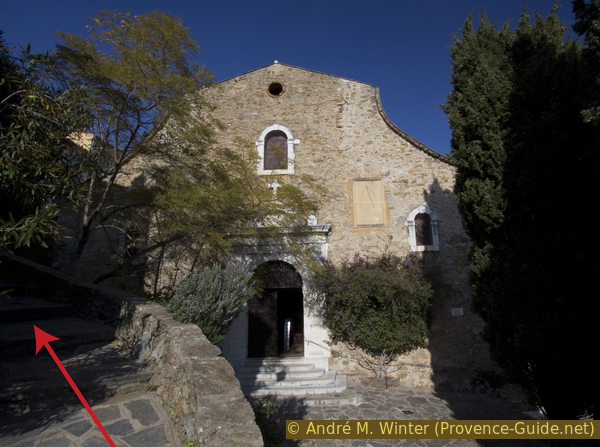
Chapel of Notre-Dame de Constance
Hike around Bormes les Mimosas with sea views
hike
easy
2 h
yes
yes
shelter
mountain
Introduction
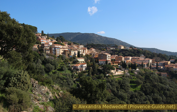
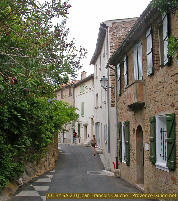
The village of Bormes-les-Mimosas does good tourist marketing, the village is always decorated with flowers and otherwise very spruced up. It is true that the location is attractive with a view of the bay and the islands of Hyères. Since the streets of the old town are also worth seeing, this tour starts in the town centre. The village does not extend too far into the hills, so you can quickly get out into nature and through the oak forest up to an old chapel. This is our first section with shady spots and a unique viewing platform as a reward. The descent is a slightly longer round on an easier road. Here there are always wonderful views of the Massif des Maures, the sea and the islands.
The facts
4,6 km total distance
2 h walk time
200 m total elevation
orientation easy, a short section pathless
mark 80% of the total distance
40% forest roads
35% hard-surfaced city roads
20% easy trails
5% stairs
dangers heat in summer, no water on the way out of town
children yes
useful picnic stuff
required hiking boots, hiking equipment and water
GPS coordinates (WGS84) of start and end point 43.150809,6.344332
downloads ![]()
![]()
No reproduction is permitted without the written consent of the author. (id3534)
Station on the Way of the Cross to Notre-Dame de Constance chapel
This Station of the Cross marks the entrance to the path to the chapel and we leave the village behind us.
Public transport
In this part of the coast, the train line is far inland, but there is the bus line 878 between Saint-Tropez and Toulon and the line 873 between Saint-Tropez and Hyères. An inconvenient side effect of these fast bus connections: they do not go up to the old town of Bormes, but only go to the new local area down in the valley. Take bus stop Rond-Point du Grand Bleu. One stop east, called Gare Routière, departs line 886 up to the village and the start of this tour, but only during summer months. Information and timetables at Zou! (only french).
The way to get to the village on foot:
- Longer, from down the valley: get out of the bus at the Rond-Point du Grand Bleu stop. Take the first street on the right (Route des Lavandières). Follow the large curve to the left, pass the Chemin des Restanques and take the following road on the right. Be careful, there are two of them, take the one on the left (Impasse des Gazanias). Go up a little, then take the Chemin de Saint-François on the right. Keep the same direction arriving again on roads, we fall back on the Route des Lavandières in a bend, go up and take the Sentier St. François at the height of a pedestrian crossing. Here we are again on the Route des Lavandières, go up to the bend of the departmental road. Stay here on the right and change up the main road, change sides at the pedestrian crossing then take the path in the woods of the Parc du Cigalou in the centre of the bend. Always turn right in the park to come out under the Salle des Fêtes on the D41, cross it and turn right. Just after take the stairs or the upper part of the Park and continue to climb to reach the town hall and the start of this hike. 130 meters of elevation gain and three quarters of an hour on paved road and concrete paths in addition.
Access by car
The start is at Bormes-les-Mimosas Municipal Office (Mairie), to the east of the old town.
From the D559, the coast road in the Var department, go up the hairpin bends of the D41 to the village of Bormes and follow the signs for the Parking Saint-François, this is to the east under the large square by the town hall.
Coming from Collobrières, pass the cemetery and then keep left at the Saint François chapel. You are in the east of the village and get directly to the same parking lot.
Useful parking spaces
The free St. François car park is located above the village. In summer, avoid Wednesdays because it's market day in Bormes. More parking possibilities at the cemetery on the road to Collobrières.
No reproduction is permitted without the written consent of the author. (id2906)
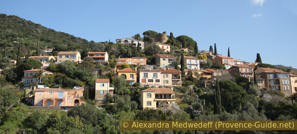
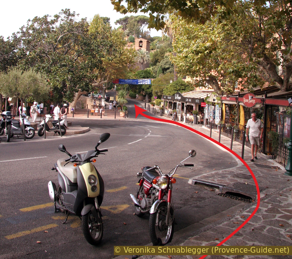
Bormes seen from the southwest
Hints
The path up to the chapel is steep and faces south. We usually try to do the ascent differently on tours like this, but this path has an old and quite bumpy paving with natural stones. It is visually beautiful, but breakneck in the descent. However, going uphill is much better.
Notre-Dame de Constance Chapel is only open when it is manned by a volunteer, which is usually the case on public holidays and on particularly fine days in winter.
The town's tourism promotion is a bit over the top when it comes to mimosas. There are indeed a few, mostly planted in the village, but the showy plant is rarely seen in the surrounding woods. The round is worthwhile in all seasons, it is not necessary to depend on the mimosa blossom. To see lots of these flowers, one has to do this tour: Mimosas in the Massif du Grand Duc.
No reproduction is permitted without the written consent of the author. (id3225)
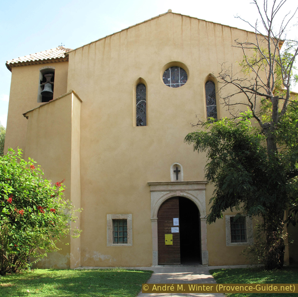
St. François de Paule chapel in Bormes
The tour is easy, well marked and signposted. You will find either white-red markings of the long-distance hiking trails (GR), brown signs in the local area to the cultural sights or arrows of the hiking trails of the municipality (photo, "Circuit pédestre n°7 Notre Dame de Constance, Parc du Mimosa").
The whole region is a zone with a high risk of forest fires. In summer, but also in other seasons when it is very dry or by strong winds, access to the forest areas can be regulated. As a result, the roads may be closed to traffic and/or the trails prohibited to hikers. Current information: Map of access to the forests of the Var (also english). The map shows the colours green, yellow, orange and red which correspond to levels of danger.
The sections
- Ascent through the town to the castle and further through the forest to the chapel
- Descent via Cuberte on a broad forest ridge
- Descend into town and return to the municipal office
No reproduction is permitted without the written consent of the author. (id3526)
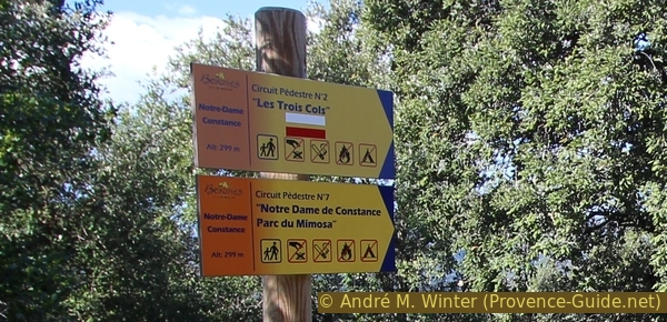
Signpost of path #7
We mainly follow the lower marker.
Section 1: Bormes - Chapelle ND de Constance
➙ 1,5 km ... 1 h ➚ 160 m ➘ 0 m ↝ easy
45% hard-surfaced city roads, with marks
10% stairs, with marks
45% easy trails, with marks
The clues
- Square in front of the town hall and Saint François chapel, 150 m
- Saint-Trophyme Church
- Small cactus park and terrace by the castle
- Ascent to Notre Dame de Constance chapel, 315 m
Ascent through the city and then over the Way of the Cross.
At first it goes through the village with a few stations worth seeing. Afterwards, however, steeply through the forest to the chapel.
traverse = passage
château = castle
office du tourisme = tourist office
vers = to
église = church
At the large open space at the municipal office, you should look west for a better view of the village and its colorful houses. Large umbrella pines stand above the last village houses, with an old castle hidden underneath. We'll pass here later on the way up.
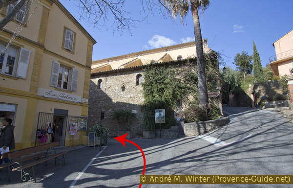
Leave the square to the north. Across the street, you can walk briefly to the St. François de Paule chapel and its small park.
No reproduction is permitted without the written consent of the author. The permission of use was kindly given to Provence-Guide.net on 10 October 2019. (id3226)
Hairpin bend in Bormes-les-Mimosas
Go straight down to the church tower.
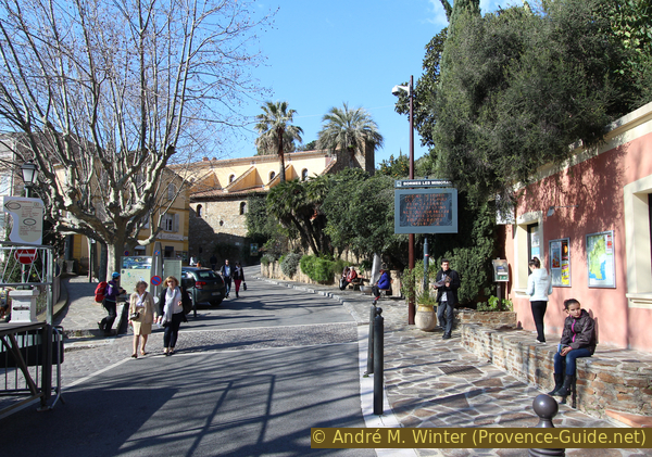
Then turn left down the main street and straight ahead into the village via the Place Gambetta. The tourist office is on the right hand side, where a folding map with hikes in this region is also sold. Hike number 7 on this map serves as the basis for this tour description.
No reproduction is permitted without the written consent of the author. (id3517)
Place Gambetta in Bormes
The tourist office (office de tourisme) is on the right.
Going straight across the square you will see a palm tree ahead and a sign pointing to the Castle (Château) and Chapel (Chapelle) on the right. However, we turn left to see the 18th-century Saint Trophyme church.
No reproduction is permitted without the written consent of the author. (id3518)
Palm tree in front of the church of Bormes les Mimosas
From the church square with the church entrance behind you, up the stairs on the right. At the top, turn right again and immediately left onto Avenue des Lauriers Roses and continue upwards.
No reproduction is permitted without the written consent of the author. (id3539)
Church forecourt of Saint-Trophyme in Bormes
Shortly thereafter we turn right onto the Traverse du Château. This is a shortcut of the road and, due to the relief, a stairway and no crossing ("traverse"). Halfway there is a small public park on the left with many cacti and other thermophilic plants.
No reproduction is permitted without the written consent of the author. (id3538)
Ascent to the castle on the right
At the end of the stairs on the left there is a last opportunity to take a break with a good view on the terrace next to the castle (which cannot be visited).
No reproduction is permitted without the written consent of the author. (id3537)
Place de la Traverse du Chateau
vers = to
oratoire = shrine
chemin de croix = way of the cross
traverse = passage
château = castle
vue = view
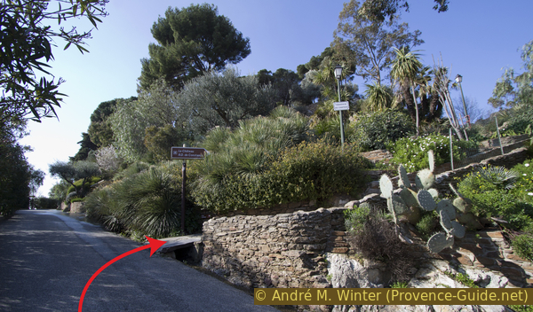
You don't see much of the castle, so we literally turn our backs on it and look for the steepest uphill road, the Chemin de Constance is our choice (photo). Just go straight up until the road turns into an even steeper concrete fire road. This is Piste de Fontone, you can come back here if you take the shortcut of the tour, see also under Fontone water tank for more information.
No reproduction is permitted without the written consent of the author. (id3536)

Ascent over the Chemin de Constance
Walk a few more meters up this steep concrete road and look for a station of the Cross and markers under the trees on the right. To get started, you have to climb over the rock for a short while (photo), after that the path becomes easier.
No reproduction is permitted without the written consent of the author. (id6142)
Start of the Via Dolorosa
You can immediately see the very old path, which rises steadily and consistently in hairpin bends. This Way of the Cross is paved with natural stones, partly in the Calade method, where stones are anchored vertically so as not to slide in steeper sections, as flat-lying slabs would. The path is not in good condition, the stones are irregular and it is easy to stumble. However, going up is much easier than going down. If you start early in the morning, it gets less hot here. There is shade, but only in sections.
No reproduction is permitted without the written consent of the author. (id3533)
Calade to the Notre-Dame de Constance chapel
oratoire = shrine
chemin de croix = way of the cross
vue = view
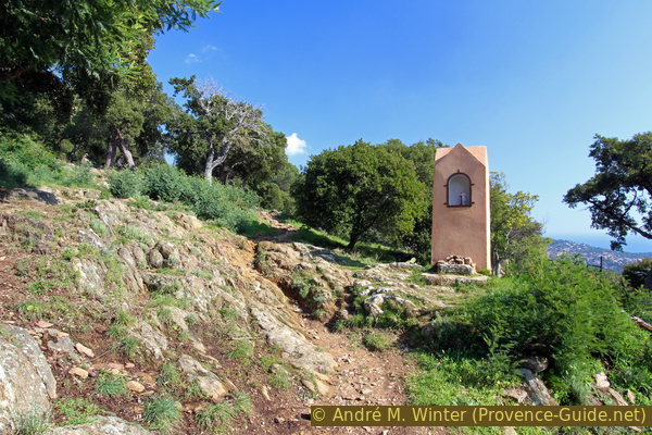
You can hardly see anything of the chapel until you stand directly in front of it. After a last Station of the Cross you can see the vantage point on the left and the chapel on the right.
As is often the case in Provence, it has a small, open vestibule with benches where you can also shelter.
No reproduction is permitted without the written consent of the author. (id3528)
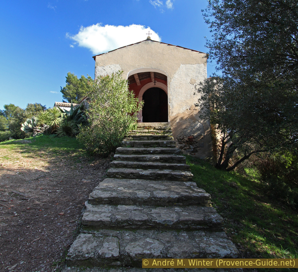
Last steps to Notre-Dame de Constance chapel
The chapel was built in the 12th century on the ruins of a temple to Diana. The small windows were bricked up for a long time and were reopened during the 1987 renovation.
It is only open when a volunteer is here. This is mostly the case on public holidays and on nice days in winter. The tourist office on the way there can provide information.
No reproduction is permitted without the written consent of the author. (id3529)
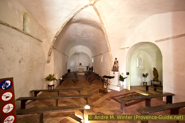
Skewed nave of the chapel ND de Constance
Section 2: ND de Constance - Mont des Roses
➙ 1,5 km ... 25 min ➚ 0 m ➘ 130 m ↝ easy
20% easy trails, few marks
80% forest roads, with marks
The clues
- Enjoy the view from the rock pulpit near the chapel
- Descend via the stairs below the viewpoint
- Descend over old paths and forest roads
- Descend the long arc over Cuberte
The descent route makes a much longer arc than the ascent. You always have a good view of the bay (Rade de Bormes). In winter you can admire some blooming mimosas here and knee and ankles will appreciate a less steep way back.
vers = to
vieux chemin = old path
vue = view
escalier = stairs
réservoir rouge = red water tank
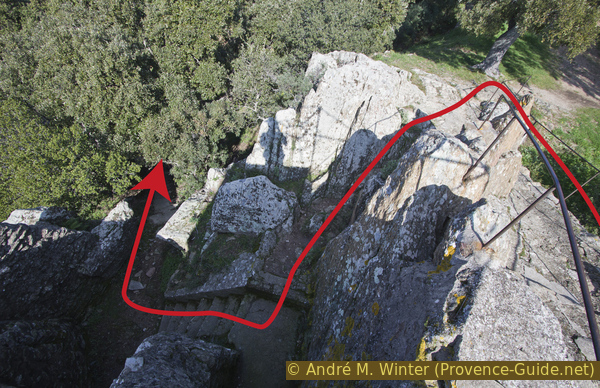
You cannot see the chapel from below because it is surrounded by trees. That's why you need a viewing platform to see the valley from this high point. It is located on a small rock, to which an easy path leads up (picture).
Note the "hole" between the rocks in the middle of the picture, we need it for the rest of our tour!
No reproduction is permitted without the written consent of the author. (id3530)
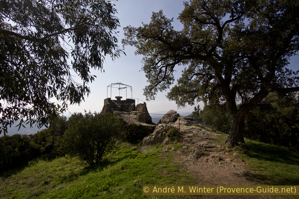
Viewpoint at Notre Dame de Constance chapel
There is an orientation table on the small platform that explains the view. Along the coast you can see from Cap Nègre in the east to Hyères in the west. But there is also a good view of the forests of the Massif des Maures.
No reproduction is permitted without the written consent of the author. (id3531)
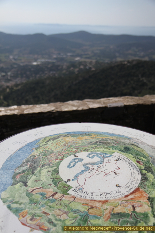
Panoramic table near the chapel
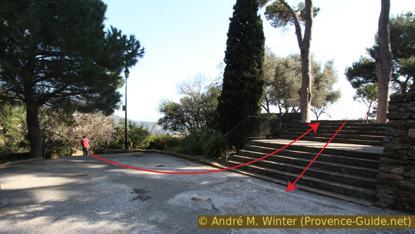
For the descent you don't have to walk along the marked long loops of the forest road north of the chapel. You can go down directly from the viewpoint and thus shorten the first hairpin bend: looking from the panoramic table back to the chapel, you can see steps on the bottom left that seem to lead under the platform. So we go down from the viewing platform and where the left railing ends, we climb slightly over the rock to the left to these same stairs. They lead past ruined houses in several sections, after the last we end up at the end of a forest road. Here you turn right and you quickly arrive into a hairpin bend in the larger forest road (old red tank on the right). Now continue straight down the forest road.
No reproduction is permitted without the written consent of the author. (id3532)
Old stair as a direct way downhill
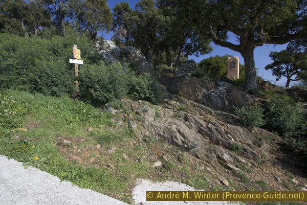
A second loop can be shortened by going straight ahead in the next left-hand bend. The round marked as Sentier N°7 also continues straight here, a signpost is in the shadow in the middle of the picture.
No reproduction is permitted without the written consent of the author. (id3527)
Forest road, from which the path continues straight ahead in the hairpin bend
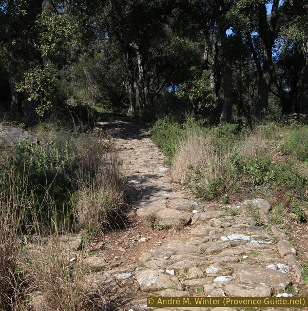
It is again an old path paved with stones. Keep left at a fork in the course. It can be dark and cold here in winter.
No reproduction is permitted without the written consent of the author. (id3525)
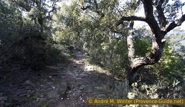
Old paved path in the oak forest
When the old paved path (on the right in the photo) meets a forest road, continue downhill on this to the right and shortly afterwards turn sharp left (further back in the photo). This is the fire brigade road A640, on which we are now walking longer.
No reproduction is permitted without the written consent of the author. (id3524)
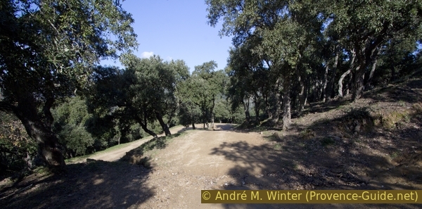
Crossings of forest roads north of the chapel N.-D. de Constance
The tour now continues straight ahead on the wide forest road. However, at the green water tank (photo) you can shorten the round via the steep Piste de Fontone. This takes you directly to the concrete section at the beginning of the Way of the Cross.
No reproduction is permitted without the written consent of the author. (id3523)
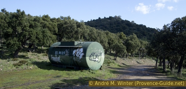
Watertank on the Piste de Fontone forest road
réservoir vert = green watertank
de la chapelle = from the chapel
vers = to
château de Bormes = Bormes castle
bancs en pierre = stone bench
château d'eau = water reservoir
avec vue = with view
ancienne antenne = old antenna
A little further on there is another gravel path to the left. This leads to a brick cistern. If you go up the steps, you have a view of the entire ascent from the village to the chapel. The gravel road also leads down to the village, but it is private and often closed.
It is worthwhile to take a look at the surrounding forest. Here natural menhirs are scattered around like pillars. Like the Crête du Caroubier ridge (which we will cross shortly afterwards), they are vertical and thus defy erosion.
No reproduction is permitted without the written consent of the author. (id3522)
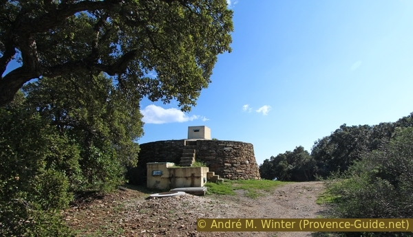
Cuberte water tank
The forest next to the forest road is gradually thinning out and we should soon see the radio mast and the end of the colony Lotissement du Mont des Roses road (photo). Before that, we turn left and continue downhill. The remains of the base of an older antenna (still noted in current maps) can then be seen on the right below the forest road.
No reproduction is permitted without the written consent of the author. (id3521)
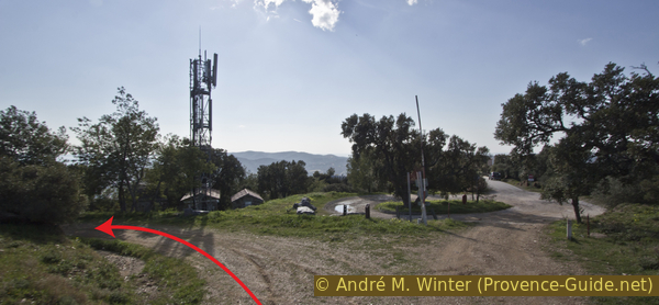
Mast at Mont des Roses
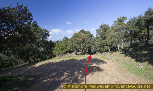
Section 3: Mont des Roses - Bormes
➙ 1,6 km ... 35 min ➚ 40 m ➘ 70 m ↝ easy
40% forest roads, with marks
60% hard-surfaced city roads, without marks
The clues
- Continue down the forest road
- Left on the asphalt road
- Uphill back to the village and the starting point
We now start the way back to the village and to civilization. Before the village there is a short counter ascent.
Here you are more exposed to the sun and there is hardly any shade to be found. This area is called Parc des Mimosas and from the end of January to February you can see blooming mimosas here. However, there are not very many trees. If you're in the area at this time, we recommend the tour east of the Estérel Massif: The Mimosas in the Massif du Grand Duc.
No reproduction is permitted without the written consent of the author. (id3520)
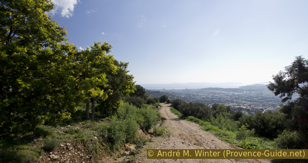
Forest road in the Parc des Mimosas
On the descent, Bormes-les-Mimosas is seen from a different angle! The outstanding house on the ridge is the municipal office, our starting and ending point.
No reproduction is permitted without the written consent of the author. (id3519)
View of Bormes from the forest road in Parc des Mimosas
château = castle
office du tourisme = tourist office
vers = to
The forest road leads us down to the paved Chemin de la Verne, here left uphill to the village. Continue on the same street, but it changes its name and is now called Rue Carnot (photo). Further ahead are the souvenir shops and the Saint-Trophyme church, which we know from the way up.
Rue Carnot in Bormes as we see it on the way back
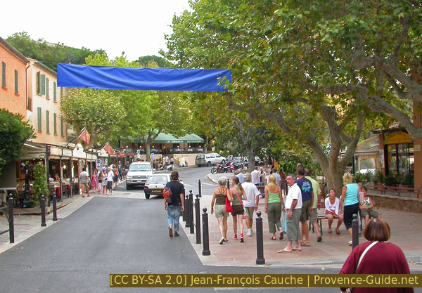
We also cross the Place Gambetta again and come to the bend in the main street with the inviting bistros and restaurants. This is the right time for a pleasure detour!
Place Gambetta seen on the way back
Sources and additional information
It is better to have a good topographic hiking map: this tour is on the IGN map "Le Lavandou, Corniche des Maures, Parc National de Port-Cros", scale 1:25000, 3446ET.
If you don't want to bother with a paper map, you can also use mapping apps on your cell phone. On the one hand, it is the Cartes IGN app from the official map service. However, it requires access to the data network and this is sometimes difficult in canyons or remote locations.
Alternatively, you can use apps that store data directly on the device. They're generally not free, but they don't cost much. We mainly use OSMAnd, here it is possible to add contour lines, relief shading, markings and others. To store this data on your phone you need a lot of space.
Of course, one needs access to satellites for the GPS signal with any app. In some canyons this is not the case. Therefore, do not rely on the position shown, but read the map on your phone as you would read it on paper. Most apps are available for Android and iPhone. The applications usually allow us to record the route travelled and also view the GPS files offered for each of our hikes.
This page has been seen 2685 times since 20 March 2024.