The mimosas in the Massif du Grand Duc
Round in the woods above Cannes
hike
easy
2 h
no
yes
no
mountain
Introduction
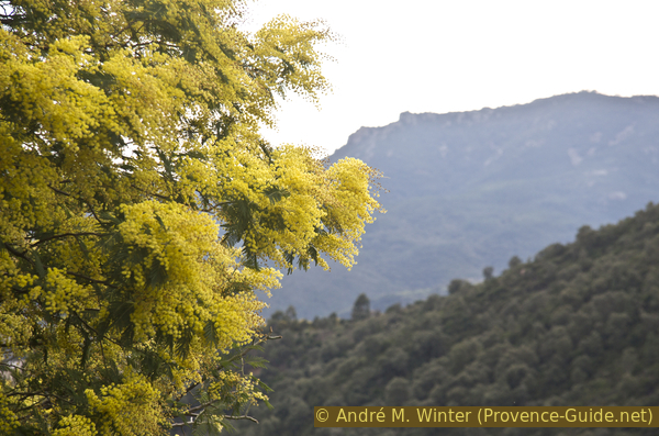
Mimosas are known as the global symbol of the French Riviera. The plant is often found in the gardens of coastal towns and villages, but it is rarer to find it in the wild and in a larger area. There are whole slopes of it in the Massif du Grand Duc on the hills behind Cannes. Of course you have to come at the right time so that the slopes are a bright yellow (see hints for more details ).
Several marked circular tours have been created in this area of the Massif du Grand Duc, this tour description covers two of them. Of course you can also do more of these rounds, a board after the ascent shows the marked paths. These loops, far from the noise and bustle of the coast, are also worthwhile at other times of the year for the views of the Cannes coast, the Îles de Lérins and the Estérel massif.
The facts
4,6 km total distance
2 h walk time
150 m total elevation
orientation easy, a short section is pathless
mark 85% of the total distance
55% forest roads
35% easy trails
10% hard-to-recognize trails
5% cross country
dangers heat in summer, no water on the way
children yes
useful picnic stuff
required hiking boots, hiking equipment and water
GPS coordinates (WGS84) of start and end point 43.555021,6.91841
downloads ![]()
![]()
No reproduction is permitted without the written consent of the author. (id3512)
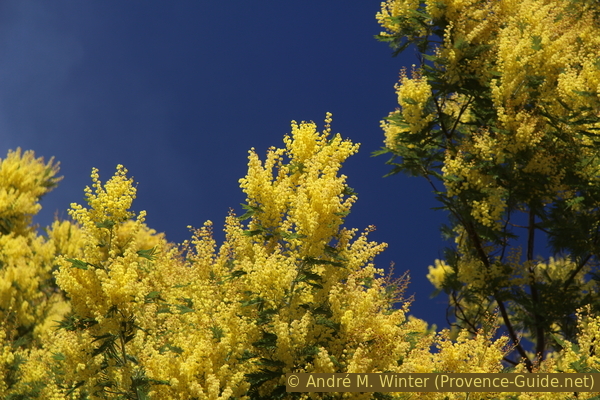
Blue sky and lots of mimosa flowers
Public transport
There is no public connection to the trailhead. The best way is to take a taxi from Mandelieu-La-Napoule (8 km from La Napoule train station, 5 km from Mandelieu bus station).
To get to Mandelieu-La-Napoule, take the a train from TER PACA (only french). You can use lines between Les Arcs and Nice or lines from Ventimiglia or Menton. However, the train station is far away in the south of the city. The Balcon d'Azur bus stop is not in front of the train station but 400 meters south at the roundabout. You can get to the centre about every 30 minutes with bus line 620 of the network Palm Bus to the Gare Routière station.
You can also walk from Mandelieu via the GR51 long-distance hiking trail to the Massif du Grand Duc. For the 290 metres of altitude you need about an additional hour for one way. From the bus station, go back to the large oval roundabout and from here head north onto Avenue Janvier Passero. After about 500 metres, two large old-pink apartment blocks follow parallel to the street on the left. Take right after those, turn left onto Avenue Beau Site, which immediately rises steeply. Now we are already on the GR51 long-distance hiking trail, even if you initially look in vain for markings. It goes up steeply between driveways to villas, but also in a left-hand bend straight ahead into the forest. This forest road soon makes a bend to the left and to the west: a direction that we now follow for a longer period of time. Without interruption, it goes up a firebreak on the ridge line. Soon it is possible to thread an old path on the right. This helps us to cut off a hairpin bend in the road. We end up back on the forest road, which now leads north-west and into a very narrow bend. At the next fork, keep left and 150 metres after the Vallon de la Vernède (another sharp bend to the left), climb the path on the right before the water reservoir. So we land directly on the parking lot in the inner curve of the road to Tanneron (D92), the starting point of the hike described here.
Access by car
The starting point is between Mandelieu on the coast and Tanneron village in the hinterland.
- Coming from the A8 motorway, take exit 40 Mandelieu and then turn left at the large T-junction. Continue until the divider ends and before Pharmacie des Thermes pharmacy, turn right onto Rue des Cyclamens.
- Coming from the Esterel Massif or the coastal road, do not follow the indications for the Hôtel du Grand Duc or the Domaine du Grand Duc, but continue towards the town center and under the motorway bridge. Turn left about 70 meters after the bridge (the Pharmacie des Thermes is on the corner, no other indications).
At the end of this one-way turn right and at the following crossing left. Now exit the town via steep hairpin bends on the Route de Tanneron (D92). After the last houses the road becomes less winding and enters a forest. In a more open right-hand bend there is a gravel parking lot on the right. This is the starting point for various hikes in the Massif du Grand Duc. Our tour starts at the barrier on the opposite side of the street.
Coming from the hinterland and Tanneron, the road is numbered D138 because we are on the border between the Alpes-Maritimes and Var departments.
Useful parking spaces
A gravel parking lot is located on a bend in the Route de Tanneron.
No reproduction is permitted without the written consent of the author. (id3515)
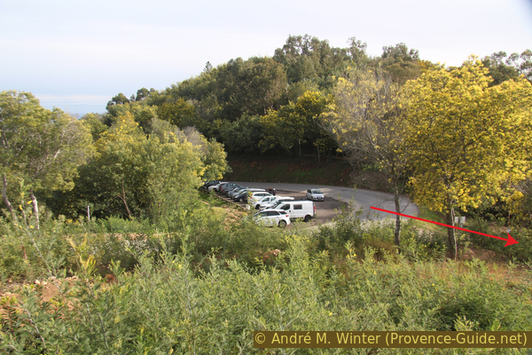
Parking in the curve of the Route de Tanneron
You have chosen the right moment when you can already see blooming mimosas here.
Hints
The round can be walked at any time of the year, but it is at its most beautiful when the mimosas are in bloom. Wild mimosa usually blooms from early January to mid-February, and it usually lasts less than three weeks! The cultivated mimosas you see around Tanneron can also bloom at different times, but these are different varieties.
Because of the quick drive and easy access, many people come here to pick up bunches of flowering mimosas. So there is a kind of a sterile edge along the forest road in the approach, where nothing blooms. This is the zone where you can easily get to the blossoming trees. Mimosas are considered a weed in the region, taking flowers with you is neither forbidden nor restricted in any way. However, we would like to point out that there is no point in taking large quantities home. They wither within a few hours (even when placed in water), since the wild mimosa are different varieties than those in the flower trade. Let's rather stay the blossoms on the bushes and trees continue to beautify nature! This is especially true for the detour that is described at the end of the tour.
We hiked here at the end of February after heavy rains and we were concerned that all the wet might have destroyed the delicate flowers, but that wasn't the case. It is therefore quite possible to start towards the end of a rainstorm, the "freshly washed" sky will only becomes bluer afterwards.
There are no sources of drinking water on the tour, so take enough water with you. The entire loop is marked, only the last detour is partially pathless.
The whole region is a zone with a high risk of forest fires. In summer, but also in other seasons when it is very dry or by strong winds, access to the forest areas can be regulated. As a result, the roads may be closed to traffic and/or the trails prohibited to hikers. Current information: Access map to the Alpes-Marimes forests (also english). The map shows the colours green, yellow, orange and red which correspond to levels of danger. The affected area is: Tanneron.
The sections
- Access to the area via the Barbossi firefighters road
- Exploratory circuit on the Parcours de Découverte du Massif du Grand Duc
- Small sightseeing tour on the Sentier Panoramique
- Back via the Barbossi dirt road and a short detour into the hills before the road
No reproduction is permitted without the written consent of the author. (id3508)
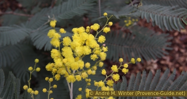
Mimosa flower
Section 1: Piste de Barbossi
➙ 1,3 km ... 30 min ➚ 65 m ➘ 0 m ↝ easy
100% forest roads, few marks
The clues
- Parking on the D92, 285 m
- Piste de Barbossi dirt road
- Large crossroads in the forest, 350 m
The tour begins behind the barriers of the forest road.
No reproduction is permitted without the written consent of the author. (id3499)
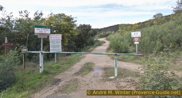
Beginning of the Barbossi road
Seen from Route de Tanneron.
sommet = summit
carrefour forestier = forest junction
piste = forest road
The way is easy, you just have to follow the forest road. It is a road that was built to fight forest fires. The sides are wide cleared so fires can be contained. You have to admit that the street would be a bit bland without the mimosa.
You can see it well in the photo: there are only flowers to be picked out of reach, because many large quantities were plucked here before...
No reproduction is permitted without the written consent of the author. (id3500)
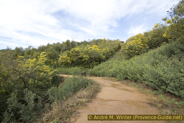
Piste de Barbossi and flowering mimosas
After about half an hour you should arrive at a large crossroads in the forest. Several marked laps start from here, two of which are selected for this tour.
Under the trees there is a large board with these routes. The cartographic representation leaves a lot to be desired, but it is sufficient for orientation. In the photo, you can see the panel on the right. We continue on the circuit marked in green, the Parcours Découverte (discovery circuit).
No reproduction is permitted without the written consent of the author. (id3501)
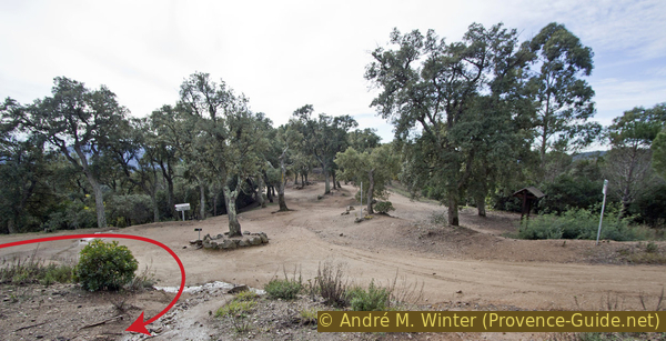
Large crossroads in the forest on the Barbossi slope
View from the north, we were approaching from the left.
Section 2: Parcours de Découverte du Grand Duc
➙ 1,5 km ... 30 min ➚ 50 m ➘ 50 m ↝ easy
80% easy trails, with marks
20% forest roads, few marks
The clues
- Climb to the viewpoints
- Walk the marked round counter-clockwise
- Return through the Vallon des Fenouillers
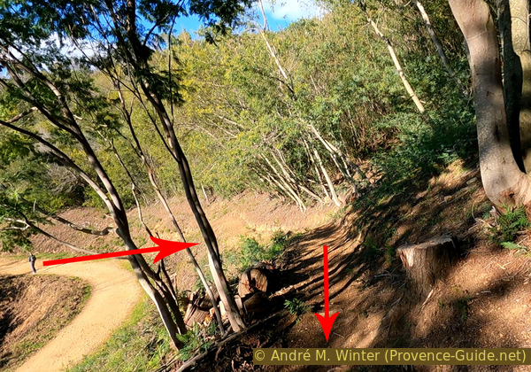
If you arrive via the Piste de Barbossi dirt road, the further round is immediately to the right at the top of the embankment by the picnic tables. The trail can be washed out in winter.
No reproduction is permitted without the written consent of the author. (id3502)
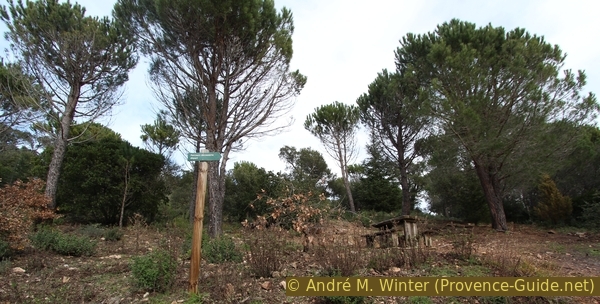
Beginning of the circular route Parcours de Découverte du Grand Duc
carrefour forestier = forest junction
piste = forest road
vers = to
sentier = path
découverte = exploration
The round is done quickly. We are no longer in a mimosa forest here, there are more pines and cork oaks. The path is marked with short posts in the ground. The numbers on it are a bit confusing, they mark the distance walked from the starting point at the junction in the forest, this loop is 1320 meters long. Other posts explain plant species.
No reproduction is permitted without the written consent of the author. (id3503)
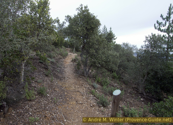
Waymarking on the Parcours de Découverte du Grand Duc
From up here you can see the mimosa forests further down, the Golfe de Napoule and Cannes on the left, and the Massif de l'Estérel on the right.
No reproduction is permitted without the written consent of the author. (id3504)
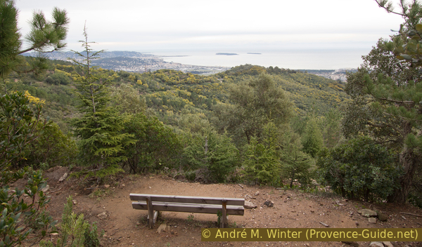
Bench with a view over Cannes
Away from the forest roads, the paths are a bit bumpy (photo). After heavy rains, which are common here in winter, the path can be washed out and littered with rocks or branches. That's why sturdy mountaineering boots are recommended for this easy tour.
No reproduction is permitted without the written consent of the author. (id3507)
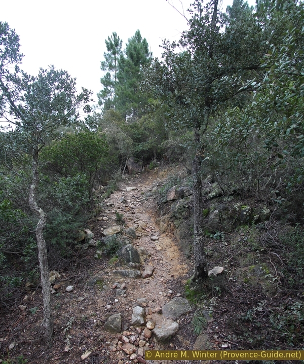
Path of the Parcours de Couverte du Grand Duc
Here we are in a cork oak forest. These trees do not grow very large and can withstand forest fires. That doesn't mean they're invulnerable, as you can see on this hill. Many trees are dead or clearly diseased. Several reasons and interacting factors are responsible for this: first, the repeated droughts of the climate change and the defoliating caterpillars of the gypsy moth (Lymantria dispar) weaken the trees. Furthermore, the cork bark is damaged by the cork oak worm (Bupreste Corœbus bifasciatus) and the wood-eating beetles of the genus Platypodidae (Platypus cylindrus) also weaken the supporting wood. Finally, a fungus (Hypoxylon mediterraneum) kills the trees completely.
No reproduction is permitted without the written consent of the author. (id3506)
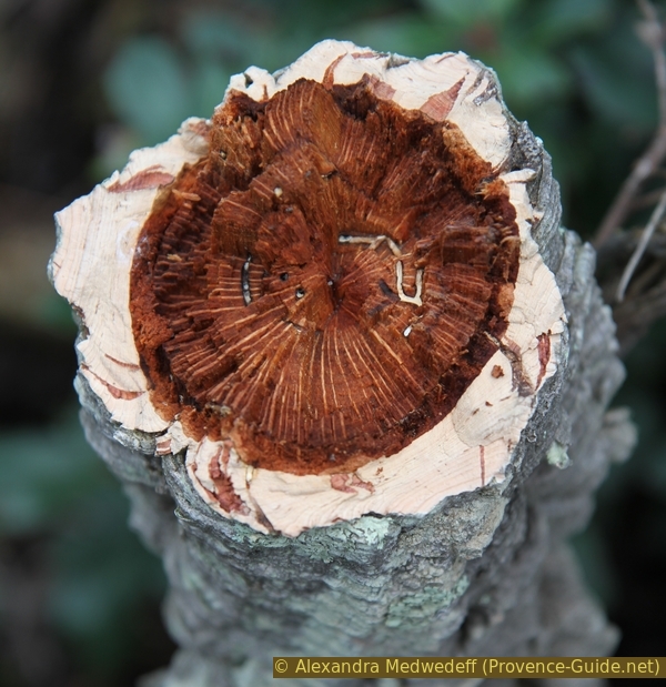
Freshly cut trunk of a cork oak
Our path becomes flatter and you can get through the forest between two hardly noticeable elevations. The forest thickens because we are now changing to the north side. On the Mediterranean coast, this means less drying sun and less wind.
The trail crosses a forest road (photo) that heads north and also out onto the Route de Tanneron. It now continues downhill towards the forest crossing. First a bit down into the valley of Vallon des Fenouillers, follow the hairpin bend and head south again under very large cork trees down to another forest road. Here left and slightly uphill again to the crossing.
No reproduction is permitted without the written consent of the author. (id3505)
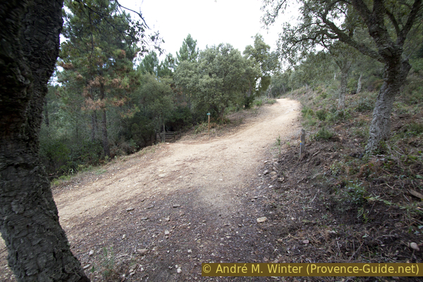
Our path crosses the forest road Piste du Grand Duc
Section 3: Parcours panoramique du Grand Duc
➙ 0,4 km ... 15 min ➚ 10 m ➘ 10 m ↝ easy
100% easy trails, with marks
The clues
- Go up left of the water reservoir
- Counter-clockwise around the crest to the viewpoint
- Return to the forest crossing via the east side
The path is marked with short posts in the ground. The route is marked in orange on the board at the large junction.
carrefour forestier = forest junction
piste = forest road
vers = to
sentier panoramique = panoramic trail
sentier du chêne-liège = cork trail
The small round is done very quickly. The main purpose of this trail is to offer a view to the southwest of the Massif de l'Estérel (morning light is better here). After a few minutes, we come back to the crossroads in the forest one last time.
No reproduction is permitted without the written consent of the author. (id3509)
Mimosas in front of a ridge of the Massif de l'Esterel
Section 4: Piste de Barbossi - Pt. 324
➙ 1,4 km ... 40 min ➚ 20 m ➘ 85 m ↝ average
60% forest roads, few marks
10% cross country
30% hard-to-recognize trails, without marks
The clues
- Take the Piste de Barbossi dirt road back to the D92
- Ascend in the direction of the power pole
- Down the ridge along a mountain bike trail to the car park
The way back is even easier than the way there: it's downhill. However, you can make a small detour north of the forest road just before the parking lot. This only pays off when the mimosa is in bloom, because up here there are fewer flower rippers than down on the road. Leave the flowers on the trees, the few hikers who come up here will thank you!
vers = zur
carrefour forestier = forest junction
piste = forest road
2e gué bétonné = 2nd concrete ford
zone défrichée = cleared area
pylône = power pole
ligne haute tension = power line
ruches = beehives
The Piste de Barbossi dirt road goes continuously downhill from the forest crossing and repeatedly crosses small dry valleys. Two of them have concrete fords on the road. About halfway between the junction in the forest and the D92 motorway, the second ford serves as a reference point. Another feature here: the road makes a right angle to the right at the height of the ford. About 320 metres after the ford there is another right turn, but here we take the path up the embankment to the left.
No reproduction is permitted without the written consent of the author. (id5888)
Path up to the ridge
The mimosa often sprout through the roots and therefore you have to clear regularly to give larger trees a chance. It is therefore possible that the slope is littered with more or less tall shoots. Some very large and old mimosa trees are striking in this area.
No reproduction is permitted without the written consent of the author. (id3511)
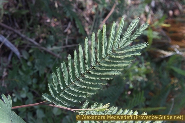
Green-silvery leaf of a wild mimosa
Ascending, you come to the weak ridge that runs between the forest road and the road (behind it). Up here you may find the most beautiful trees that bloom all the way to the ground!
No reproduction is permitted without the written consent of the author. (id5887)
Mimosa seed pods
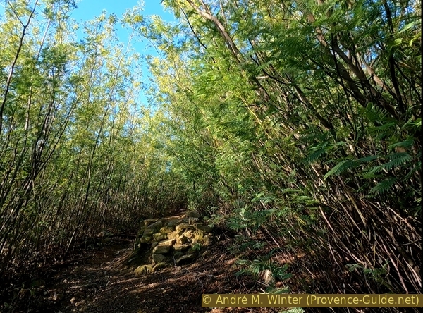
On the ridge line we take the path to the left further uphill to reach a flatter area after about 100 meters. Here we are on paths that are mainly used by downhillers. Here you are also in a veritable tunnel of mimosas. Now you can make two short detours.
No reproduction is permitted without the written consent of the author. (id3513)
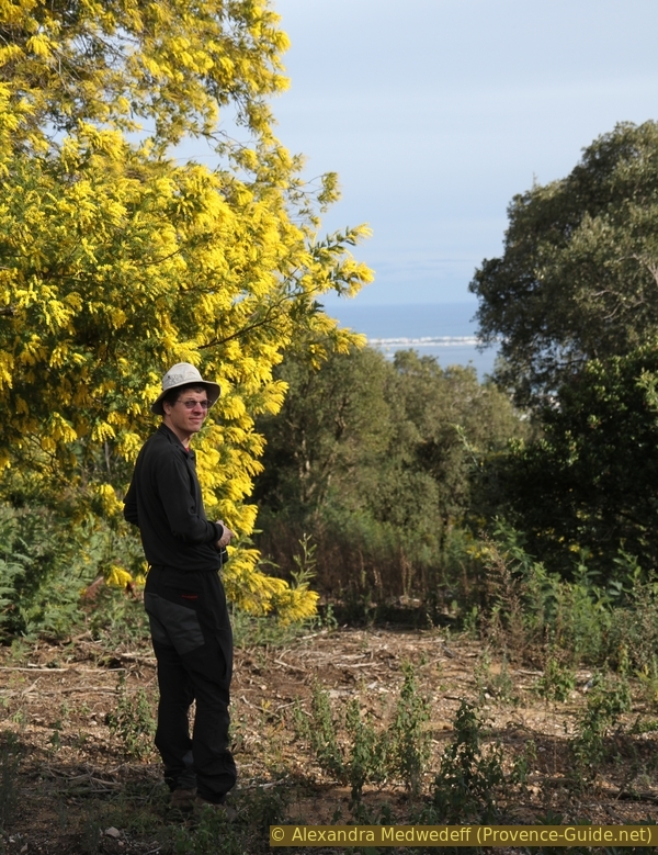
The author of the tour at a large mimosa tree in full bloom
Either you just keep going up to a jump for downhillers. Here the vegetation tunnel is even more impressive.
No reproduction is permitted without the written consent of the author. (id5885)
Alley of mimosa and downhill jump
Or you can go right to an open area with beehives around the hill at 324 meters above sea level. Keeping left after the barrier bypasses most of the beehives.
There is no mimosa honey because bees cannot make viscous honey from this acacia species. The hives are placed here because the heat draws the bees out and they seek food. The mimosas serve them only as food.
After both detours, you come back to the flatter area and go up on the second open ridgeline. This way you can quickly get back to the starting point.
No reproduction is permitted without the written consent of the author. (id5884)
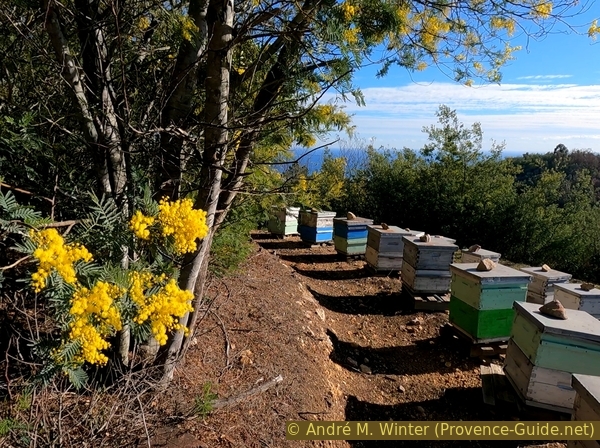
Beehives at point 324
Sources and additional information
It is better to use good topographic hiking maps: This tour can be found either on these two IGN maps "Cannes, Grasse, Côte d'Azur", scale 1:25000, 3643ET (covers the coast in the east) and "Haute-Siagne", Scale 1:25000, 3453ET (includes Lac de St. Cassien).
If you don't want to bother with a paper map, you can also use mapping apps on your cell phone. On the one hand, it is the Cartes IGN app from the official map service. However, it requires access to the data network and this is sometimes difficult in canyons or remote locations.
Alternatively, you can use apps that store data directly on the device. They're generally not free, but they don't cost much. We mainly use OSMAnd, here it is possible to add contour lines, relief shading, markings and others. To store this data on your phone you need a lot of space.
Of course, one needs access to satellites for the GPS signal with any app. In some canyons this is not the case. Therefore, do not rely on the position shown, but read the map on your phone as you would read it on paper. Most apps are available for Android and iPhone. The applications usually allow us to record the route travelled and also view the GPS files offered for each of our hikes.
This page has been seen 19378 times since 20 March 2024.
No reproduction is permitted without the written consent of the author. (id5886)
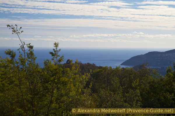
Sea view and the Pointe de l'Aiguille