Connect Vence and St. Paul on foot
The verdant valley of Malavan separates the unequal villages
hike
easy
1 h 45 min
yes
yes
built-up area
walk
Introduction
Vence and especially Saint Paul are two places worth seeing but also very touristy. Vence is a town with an old centre and several large markets, Saint Paul is a pretty village overlooking the sea. The number of visitors is dizzying and the pressure to settle is high, unfortunately old paths are disappearing and nature suffers quite a bit from these interventions. Arriving by car becomes like running the gauntlet, parking is expensive or not possible at all.
That's how we got the idea to look for old connecting routes between the two villages, there are still two usable ones off the main traffic arteries. They are also officially marked, but very few people walk here. So let's get to the region as we want, put on our trekking boots and leave parking lots and motorcades behind!
The facts
8,8 km total distance
1 h 45 min walk time
280 m total elevation
orientation easy in nature, in the urban area, follow the instructions in the text
mark 70% of the total distance
35% hard-surfaced city alleys
30% easy trails
10% hard-surfaced quiet side streets
10% hard-surfaced city roads
10% hard-surfaced paths
<5% stairs
<5% hard-surfaced country road
dangers slippery in wet weather
children yes
useful picnic stuff
required trekking shoes, hiking gear and water
GPS coordinates (WGS84) of start and end point 43.722785,7.107339
downloads ![]()
![]()
No reproduction is permitted without the written consent of the author. (id3355)
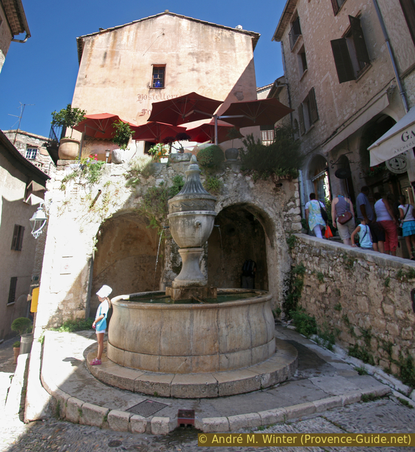
Fountain in Saint Paul de Vence
Public transport
Vence is easily accessible by bus. The cities Nice and Cagnes-sur-Mer are also reachable by train.
- From Nice with lines 09, Exp3 and 655 about 30 times a day in about an hour. Not ideal: neither line leaves from Nice-Ville central station, so you have to change to the bus at Saint-Laurent-du-Var. Lines LR233 and LR400 also go to Saint-Paul-de-Vence.
- Lines 47 and Exp1 run from/to St. Jeannet and La Gaude in the vicinity. Line NVN1 heads for the large campsite La Bergerie.
- From Grasse with line 651 approximately 10 times a day.
- From Sophia Antipolis and Cagnes with line 636 approximately 3 times a day.
Information at Zou! (only french), continue under Horaires/Schedules, and enter the line number there. Tickets can be bought on the bus.
Access by car
From Nice on the A8 highway, take exit 48 Cagnes-sur-Mer and follow signs for Vence.
From Marseille on the A8 highway, exit 47 Villeneuve-Loubet, first continue parallel north of the motorway, but always follow the signs to Vence.
Useful parking spaces
The origin of this round lies in the impossibility of parking in the two cities. All parking lots are chargeable and mostly full, some are so far away that shuttle services have been set up. These car parks are well marked and hard to miss, most are also along the tour.
Since we connect the two places on two different routes on this tour, you can also try to park your car somewhere in between:
- In Saint-Paul, at the roundabout, follow the sign Fondation Maeght and go up the Chemin des Trious, stay in one of the paid parking spaces or continue for over a kilometre until you come to a Y-junction. On the left in the Chemin des Salettes and on the right in the Chemin des Cades you can find shady spots in the forest. The Chemin des Cades is on this tour, the Y junction marks the start of section 2.
- In Vence, in the streets around the chapel of Ste. Elizabeth. The chapel is at the beginning of section 4 of the circular tour.
Hints
You will mostly be lonely on the old connecting routes. The opposite applies in both places. Vence is a little quieter in the low season, except market day on fridays. Saint-Paul is overcrowded all year round. This applies every day during the long main season and on nice days in winter. Market day on wednesday.
However, the highlights of the tour remain Vence and St. Paul, the old paths in between allow nice views and lead past some chapels. If you have time, it is best to choose a day in the off-season and without a market, ideally after a thunderstorm. The sky and the towns are then swept empty.
The times given do not include visits of the cities.
In the Alpes-Maritimes department, all signposts have numbers, here you can find numbers between 140 and 250, we mention them in the description and on the maps. The order is arbitrary and has no meaning for this or other tours.
The whole region is a zone with a high risk of forest fires. In summer, but also in other seasons when it is very dry or by strong winds, access to the forest areas can be regulated. As a result, the roads may be closed to traffic and/or the trails prohibited to hikers. Current information: Access map to the Alpes-Marimes forests (only french). The map shows the colours green, yellow, orange and red which correspond to levels of danger.
The sections
- Crossing the ditch between Vence and Gardettes
- Down to St. Paul via the Chemin des Gardettes
- Through the Vallon de Malavan and up to Ste. Elizabeth
- Return to Vence via the Chemin du Camp
No reproduction is permitted without the written consent of the author. (id5322)
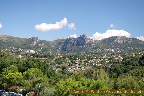
Limestone mountains north of St. Paul and Vence
No reproduction is permitted without the written consent of the author. (id5323)
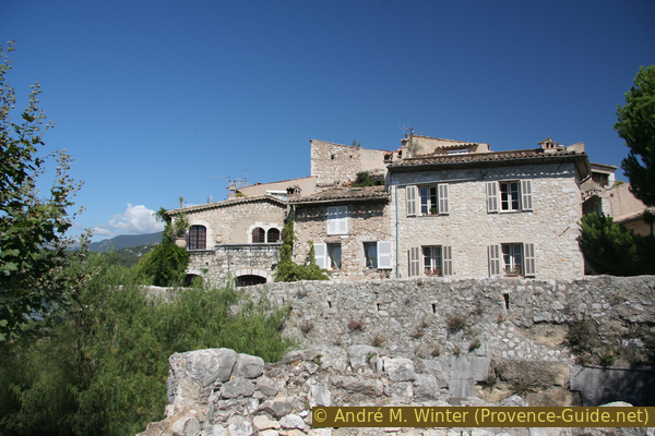
Houses in the south of Saint-Paul
Section 1: Vence Gare Routière - les Gardettes
➙ 1,4 km ... 25 min ➚ 55 m ➘ 110 m ↝ easy
20% hard-surfaced city roads, few marks
20% hard-surfaced city alleys, with marks
15% easy trails, with marks
45% hard-surfaced quiet side streets, faulty marks
The clues
- Vence bus station, 320 m
- Boulevard Emmanuel Maurel
- Sainte Anne chapel
- Chemin du Baric
- Vallon du Malavan, 225 m
- Chemin des Cades, 280 m
We quickly leave Vence to cross the Vallon de Maravan for the first time.
We leave Vence without paying much attention to the city, we will roam it at the end of the tour. The starting point is the large roundabout west of the town centre, where the bus station (called Ara) is also located. If you arrive by bus, leave the bus stop at the back, i.e. on the side where the buses come in, and immediately turn left onto Boulevard Emmanuel Maurel. Trees shade the footpath here. In a long bend to the left, the lane is divided and shortly afterwards we come to a crossroads with a chapel, which is not aligned with the current course of the road. There is a drinking water tap opposite the big cross.
After the Sainte-Anne chapel, we turn right, signpost 140 directs us to St. Paul, La Colle and Tourrettes. We are on the Chemin du Baric, which leads us straight down into a green valley. At first the road is still paved, after the last houses the path narrows and penetrates the dense forest. Below you cross the Malavan stream on a bridge with signpost 141.
No reproduction is permitted without the written consent of the author. (id3871)
Ste. Anne chapel in Vence
Opposite we climb first to the right. At the following junction (signpost 142), we do not continue on the GR653A long-distance trail, but we turn sharply to the left to get to Saint Paul. We're coming back under the power line. As soon as we arrive at the plateau, we arrive on an old forest road with remains of asphalt (signpost 250). We follow this street, it is called Chemin des Cades. We now follow a yellow marking.
We finally come to the Chemin des Sine at an Y-junction. On the right is the Chemin des Salettes, but we keep the original direction and take the Chemin des Gardettes. This is the municipal boundary between Vence and Saint-Paul, and this is also where the first section of the tour ends.
Section 2: Les Gardettes - St. Paul
➙ 2,4 km ... 25 min ➚ 20 m ➘ 90 m ↝ easy
15% hard-surfaced quiet side streets, without marks
50% easy trails, faulty marks
35% hard-surfaced city alleys, without marks
The clues
- Chemin des Gardettes
- path between villas
- Stair
- Notre Dame de la Gardette chapel
- St. Paul de Vence
We take an old path between the gardens of the villas.
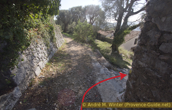
We're still a long way from Saint Paul, and roads aren't hikers' favourite routes. 200 meters after the Y-junction there is another one at right angles. Here we turn left into Chemin des Gardettes-Sine, but only as far as behind the first house. At the red hydrant (signpost 249) we take the narrow path on the right that leads between the gardens of the houses. The path runs parallel to the road and descends to Saint-Paul. On the way, two side streets are crossed, the path then continues in the same direction.
Shortly after the last crossing, the path seems to leave civilization, but this impression does not last long. We pass a former Dominican nuns' abbey, followed by the associated garden and another house. Just behind it, a stair leads down to the right. The section appears to be private but there is a public connection to the Chemin de Sainte-Claire below. Only residents are allowed to drive here. The upper path would also lead down, but the view down on the village is better from the road.
No reproduction is permitted without the written consent of the author. (id3873)
Chemin Notre-Dame and down the stair on the right
On the small road that now descends continuously, we pass three chapels: Notre-Dame de la Gardette, Chapelle de St. Charles et St. Claude and Chapelle Sainte-Claire. The first is quite large and awaiting renovation, the second is in better condition and the third is just before the old town centre.
No reproduction is permitted without the written consent of the author. (id3872)
Notre-Dame de la Gardette chapel and St. Paul in the background
There are several ideal views of the village of Saint Paul further down from the road. The best light is here in the evenings in summer.
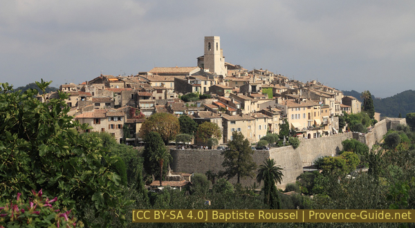
Saint-Paul-de-Vence seen from the Chemin de Sainte-Claire
The Chemin de Sainte-Claire leads us, no surprise, to the Sainte-Claire Chapel. Here you literally stumble onto the busy Route de Vence, which we have to cross carefully. Then you continue downhill towards the centre of Saint-Paul.
The last cars looking for a parking space have to turn left, but we go straight ahead. On the right is the pétanque court and in front the city gate of the well-preserved medieval old town awaits us. The ramp takes you into the village and there you can stroll freely through the streets paved with natural stones.
In the southern part you can climb the city wall. You can also get around outside under the city wall.
After the city walls you should also roam the old streets, they all seem to have been left over from the Middle Ages. There are some nice terraces, but in terms of authenticity and price, you're better served in Vence.
No reproduction is permitted without the written consent of the author. (id3356)
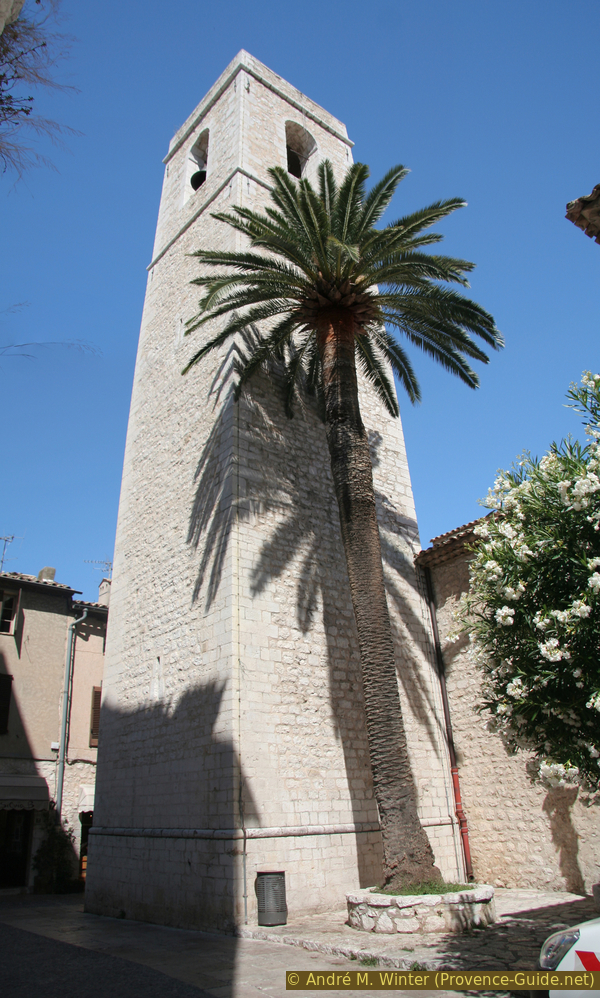
Saint-Paul church with palm tree
Section 3: St. Paul - Chapelle Ste. Élisabeth
➙ 2,7 km ... 35 min ➚ 110 m ➘ 75 m ↝ easy
30% hard-surfaced city alleys, without marks
5% hard-surfaced country road, without marks
45% easy trails, with marks
25% hard-surfaced city alleys, few marks
The clues
- Vallon de Malavan on the old path from St. Paul
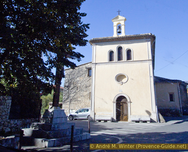
- Sainte Elisabeth chapel
On the historic route from St. Paul to Vence.
We leave the fortified village to the north again and climb back up to the main road, Route de Vence. Here we keep to the right and pass the entrance to the parking lot under the town. Shortly thereafter, after the end of the railing, our path branches off to the right into the forest (signpost 247, to Vence). Here you descend steadily through the slope into the Vallon du Malavan, the path is called Ancien Chemin de Saint-Paul. Below we don't expect a wild brook like before, but a sewage treatment plant and a road, which leads up again opposite. Here it goes steeply uphill without shade.
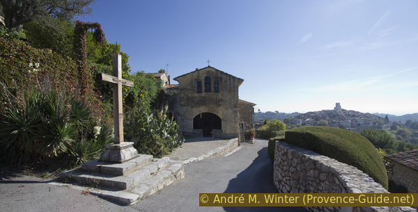
When we get to the more busy Avenue Emile Hugues, we have to make a turn to the right. At the top (signpost 147), however, to the left and immediately right again uphill to thread the course of the Ancien Chemin de Saint-Paul again (signpost 147 bis). We climb here to the chapel on the ridge.
No reproduction is permitted without the written consent of the author. (id3357)
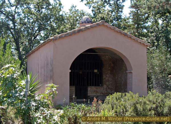
Sainte-Élisabeth chapel south of Vence
Inside, the chapel is decorated with trompe-l'oeil paintings, which unfortunately are already fading.
No reproduction is permitted without the written consent of the author. (id3358)
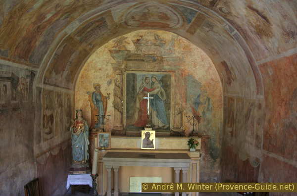
Trompe-l'oeil painting in the Saint-Élisabeth chapel
Section 4: Chapelle Ste. Élisabeth - Vence
➙ 2,3 km ... 25 min ➚ 100 m ➘ 0 m ↝ easy
20% hard-surfaced city alleys, few marks
10% stairs, few marks
30% hard-surfaced paths, few marks
10% hard-surfaced city roads, without marks
15% hard-surfaced city alleys, without marks
15% hard-surfaced city roads, with marks
The clues
- Chemin Sainte-Elisabeth, 220 m
- Chemin de la Pouiraque
- Route de Cagnes, 250 m
- Chemin du Camp
- Vence, 325 m
To get to Vence there is again a quiet path between the houses.
At the chapel we continue to the left and up, staying in the left lane, which is one-way here. 200 meters further on, in a hairpin bend in the Route de Cagnes, we descend to the right, staying on the left-hand side of the road and turning left as soon as possible onto Chemin du Camp.
A footpath begins a little further up with steps. We go up between gardens, fields and houses. So we loop into Avenue Colonel Meyere and are soon in the town centre. Continue on this busy road in the same direction.
No reproduction is permitted without the written consent of the author. (id3870)
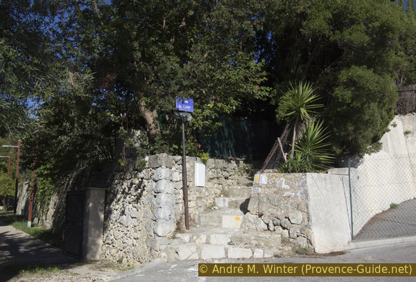
Stair at the bottom of the Chemin du Camp
After 150 meters we come straight to the medieval ramparts, where we enter the centre through the Porte du Signadour. If you are in a hurry, you can be faster by circling the centre outside to the left.
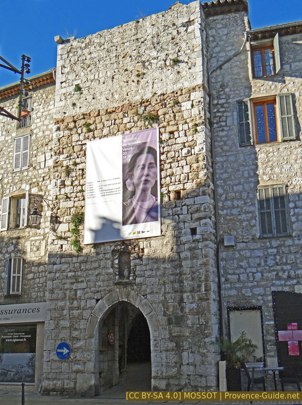
Porte du Signadour
The town centre is much larger than that of Saint Paul, and people actually live here. There are many narrow streets and small squares next to the big one by the municipal office.
No reproduction is permitted without the written consent of the author. (id3359)
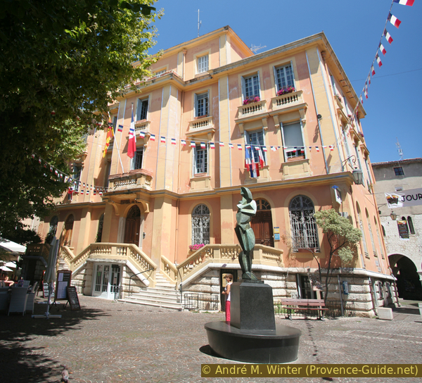
Municipal Office of Vence
Going around the municipal office on the left you come to rue du Peyra and the square and fountain of the same name. The fountain replaced a much older one from 1578 in 1822. Until 1886 this was one of only three water points in the city. Today he donates drinking water from La Foux source to the hiker.
Behind the fountain we leave the old town through the Porte du Peyra. Immediately after that, turn left and immediately right onto Avenue de la Résistance, the road will take us directly to the roundabout of the starting point.
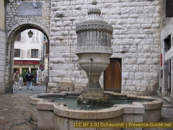
Fontaine du Peyra
The street crosses the large Place du Jardin, which is ideal for a rest on one of the terraces. If you come here in the morning, you will also find a market (every day).
No reproduction is permitted without the written consent of the author. (id2201)
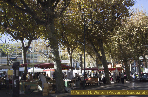
Producers' market in Vence
Those who started their tour elsewhere do not necessarily have to proceed to the roundabout. Opposite the Banque Populaire branch and next to the entrance to the Marie Antoinette central car park, pass a narrow passageway called rue du Pavillon. At the end you come to the Rue de Stamford and via steps to the Avenue Emile Hugues. We cross this one and exactly opposite we take the Chemin de Sainte Anne. It leads straight to the chapel of the same name, where you can continue on section 1.
Sources and additional information
It is better to use a good topographical hiking map: This tour is on the IGN "Cannes, Grasse, Côte d'Azur" map, scale 1:25000, 3643ET.
If you don't want to bother with a paper map, you can also use mapping apps on your cell phone. On the one hand, it is the Cartes IGN app from the official map service. However, it requires access to the data network and this is sometimes difficult in canyons or remote locations.
Alternatively, you can use apps that store data directly on the device. They're generally not free, but they don't cost much. We mainly use OSMAnd, here it is possible to add contour lines, relief shading, markings and others. To store this data on your phone you need a lot of space.
Of course, one needs access to satellites for the GPS signal with any app. In some canyons this is not the case. Therefore, do not rely on the position shown, but read the map on your phone as you would read it on paper. Most apps are available for Android and iPhone. The applications usually allow us to record the route travelled and also view the GPS files offered for each of our hikes.
This page has been seen 3360 times since 20 March 2024.