Hike in between the Rochers des Mourres
Geological curiosity on a human scale
walk
easy
1 h 45 min
yes
yes
built-up area
mountain
Introduction
This geological curiosity is located above the town of Forcalquier. The landscape is characterized by surprising rock domes, all of which are a little larger than we are. It's like walking in a forest of giant mushrooms. The vegetation is few and far between, so in summer it looks like a desert.
The facts
6,2 km total distance
1 h 45 min walk time
180 m total elevation
orientation easy
mark 100% of the total distance
35% dirt roads
35% hard-surfaced city alleys
25% easy trails
5% hard-surfaced city roads
dangers heat in summer, no water on the way
children yes
useful picnic stuff
required hiking boots, hiking equipment and water
GPS coordinates (WGS84) of start and end point 43.959718,5.780868
downloads ![]()
![]()
No reproduction is permitted without the written consent of the author. (id2331)
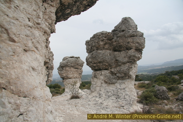
Rocks of Mourres de Forcalquier
Public transport
Buses 62, 65 and go to Forcalquier. More information at Zou! (only french).
Access by car
The starting point is in the town square of Forcalquier: Place du Bourguet.
The nearest motorway is the A51 between Marseille and Sisteron. Take the exit for Forcalquier and follow the indications for the car parks in the centre.
The sight can also be reached directly by car and is described under Mourres de Forcalquier.
Useful parking spaces
There are several free car parks in town, but availability depends market days in Forcalquier. On the big market day and in summer it is better to aim for the car park in the Mourres area on the road to Fontienne.
Geological consideration
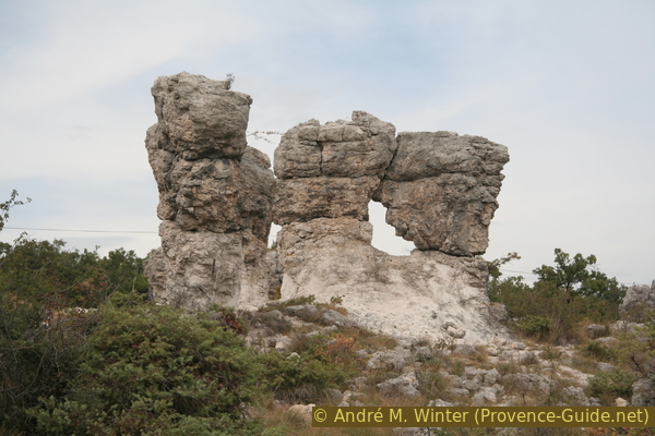
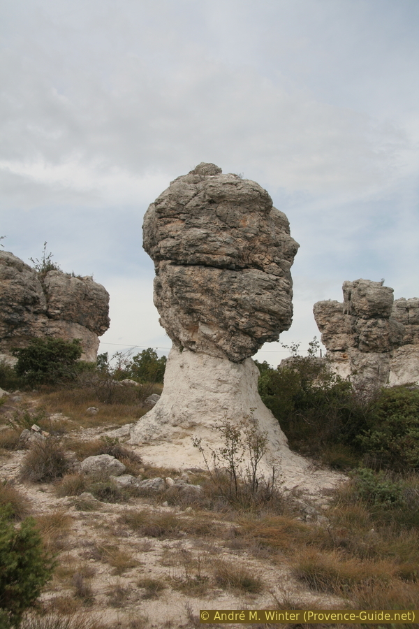
The formation of these rocks occurred around 25 million years ago in shallow fresh water, perhaps in the area of an estuary delta in a lake. Soft and uniform lime formed in it, which is called Calcaire de Reillanne. The natural soil on which we walk is currently made of this type of lime and the base of the stone pillars is also made of it.
The heads of the columns are made of much harder limestone, which formed on small islands of vegetation in what was then a shallow lake. These islands consisted of grasses growing in dense clumps. A harder layer of lime formed around their roots. With the slow rise in the water level, the clumps of grass grew upwards and accordingly took root one level higher. This is how another hard layer formed on top and this is how the horizontal layers that you can see today in the heads on the rock pillars came into being.
Later, the grassy islands were completely submerged and overlaid with a thick layer of soft limestone. The water receded and the area was tilted slightly by tectonic shifts. Erosion by surface water immediately began to take effect: the soft top layer was washed away. When the plane of the hard islands emerged, they remained and thus progressively rose above the plane that was being eroded.
Today these forms consist of half hard layers at the top and about half softer rock at the bottom. However, erosion is constantly progressing, eroding the plain and the soft base of the columns. Sooner or later the pillars will become too tall or too thin and will fall over.
The shapes look a bit like Goblin Valley State Park (only french) in North America, but their formation is different.
No reproduction is permitted without the written consent of the author. (id2327)
Mourres de Forcalquier
Hints
Erosion is further accelerated drastically by visitors and by trampling on the sparse vegetation. For this reason, the municipality tries to channel visitors along limited paths. We advise staying on this path for the sake of nature, it is marked on the map on this page.
The round can be done at any time of the year, but extreme weather conditions should be avoided. It can be extremely hot in the summer and around noon and there is hardly any shade along the entire trail. In winter there can be snow and the path can be icy.
The whole region is a zone with a high risk of forest fires. In summer, but also in other seasons when it is very dry or by strong winds, access to the forest areas can be regulated. As a result, the roads may be closed to traffic and/or the trails prohibited to hikers. Current information: Access map to the forests of Alpes de Haute Provence (also english). The map shows the colours green, yellow, orange and red which correspond to levels of danger. The affected area is: Forcalquier-Entrevennes.
The sections
- Ascend over the cemetery and to the Mourres area
- Descend east via La Parise Sud and pass a sharp borie
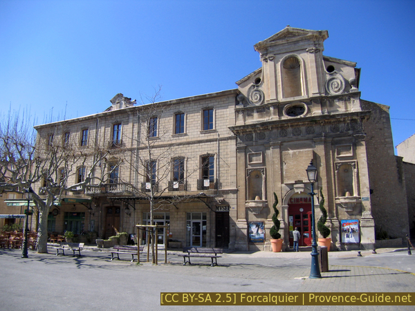
The municipal office and the cinema in the abandoned church
This is the former Visitandines monastery.
Section 1: Cimetière - Mourres
➙ 3,1 km ... 55 min ➚ 180 m ➘ 0 m ↝ easy
30% hard-surfaced city alleys, with marks
30% dirt roads, with marks
20% easy trails, few marks
10% dirt roads, with marks
10% easy trails, with marks
The clues
- Place du Bourguet, 550 m
- Mourreisses, 625 m
- Les Mourres upper area, 730 m
The tour starts from the former church, which is now used as a cinema.
Head north-east from the Place du Bourguet onto Rue Louis d'Andrieux, which is to the right of the church marked Cinéma. We continue to follow this direction without deviating too much from it. The street name changes and we continue on the Chemin des Moureisses. Here at the latest you can see the small red and white markings of the long-distance hiking trail GR653D. At the height of the cemetery, we turn more to the left and north. After the signpost at Les Mourreisses, continue straight and if the marked path leads to the left, we continue slightly to the right on a narrower path.
No reproduction is permitted without the written consent of the author. (id2328)
Drumlin of Mourres de Forcalquier
100 metres further on we come to the marked Chemin de la Parise path that takes us across the lower part of the Rochers des Mourres. We cross a road and continue along the path in the upper section to the signpost with the place name Les Mourres. On this path we crossed the entire area of the Mourres.
No reproduction is permitted without the written consent of the author. (id2330)
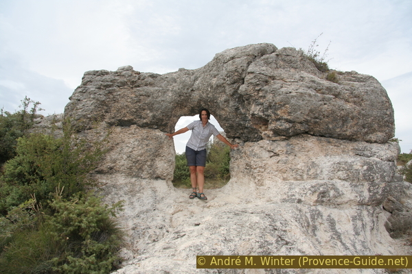
Arch at Mourres de Forcalquier
Section 2: Mourres - St. Marc
➙ 3 km ... 45 min ➚ 0 m ➘ 180 m ↝ easy
30% dirt roads, with marks
20% easy trails, with marks
40% hard-surfaced city alleys, few marks
10% hard-surfaced city roads, few marks
The clues
- Descent to the antennas, 655 m
- Descent to the borie Le Cabanon Pointu, 585 m
- Back through Avenue St. Marc
- Place du Bourguet, 550 m
At the signpost at the upper end of the Mourres, we go left downhill along the GR6 long-distance trail. The path is also known as the Tour de la Montagne de la Lure. We pass the signposts Grand Travers and Parise Sud and then pass below antennas. The path leads us to the south.
After the antennas, the path quickly becomes a paved road and continues down along a ridge to Cabanon Pointu. This large borie is on the outside of the curve. Here we turn sharp left and go back along Avenue St. Marc to the starting point at Place du Bourguet.
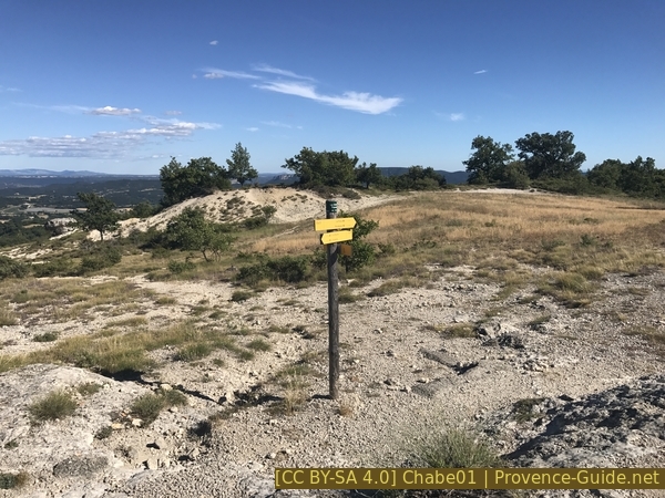
Signpost Le Grand Travers
Sources and additional information
It is better to use a good topographical hiking map: This tour is on the IGN map "Manosque/Forcalquier/PNR du Luberon", scale 1:25000, 3342OT.
If you don't want to bother with a paper map, you can also use mapping apps on your cell phone. On the one hand, it is the Cartes IGN app from the official map service. However, it requires access to the data network and this is sometimes difficult in canyons or remote locations.
Alternatively, you can use apps that store data directly on the device. They're generally not free, but they don't cost much. We mainly use OSMAnd, here it is possible to add contour lines, relief shading, markings and others. To store this data on your phone you need a lot of space.
Of course, one needs access to satellites for the GPS signal with any app. In some canyons this is not the case. Therefore, do not rely on the position shown, but read the map on your phone as you would read it on paper. Most apps are available for Android and iPhone. The applications usually allow us to record the route travelled and also view the GPS files offered for each of our hikes.
This page has been seen 2143 times since 20 March 2024.