Mont Guillaume, Col de Trampa-Latz and Lac de l'Hivernet
Via the well-known Sentier Widman to the summit and over the ridge to Lac de l'Hivernet
scramble
average
6 h
no
yes
shelter
mountain
Introduction
With over 1000 meters of altitude difference, this mountain tour is long and demanding. But the view is terrific! As the path to the viewpoint is very easy, it is worth extending the route a little and making it more challenging by continuing along the ridge behind the Saint Guillaume chapel. After the Trampa-Latz saddle, good orientation and some climbing skills are required in order to pass the romantic Lac de l'Hivernet. You should also have enough energy saved to return to the starting point. However, the difficult passage can also be avoided and the tour shortened beforehand, see section 4.
The ascent to Mont Guillaume takes place on Sentier Widman. A Swede in the service of the French army wanted to prove that skis are faster than snowshoes and used this path as an ascent route in 1897. The well-known Mont Guillaume is not a real mountain at all, it is merely the prominent end of the ridge reaching towards Embrun. You can see up the valley beyond Guillestre, across the entire Serre-Ponçon reservoir and to the Champsaur area to the west.
The facts
14,6 km total distance
6 h walk time
1170 m total elevation
orientation easy in good weather
mark 75% of the total distance
70% easy trails
20% forest roads
10% hard-to-recognize trails
5% cross country
<5% Trails with scramble passages
dangers climbing section in brittle rock, wind
children especially the duration can exhaust children
useful picnic stuff
required hiking boots, hiking equipment and water
GPS coordinates (WGS84) of start and end point 44.593532,6.475316
downloads ![]()
![]()
No reproduction is permitted without the written consent of the author. (id3597)
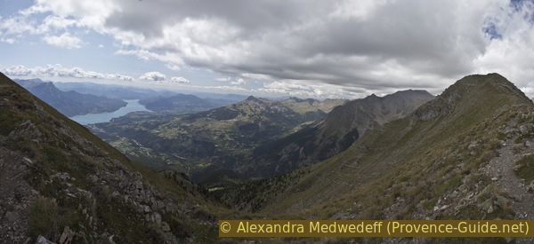
Lac de Serre-Ponçon reservoir and Vallée du Réallon
Public transport
You cannot get to the starting point by public transport. There are public minibuses in Embrun, but you can only get as far as the hamlet of Caléyèrs, which is 500 meters in altitude below the starting point. In addition, the travel times are not at all suitable for hikers. However, Embrun is easily accessible by train.
Access by car
The center of Embrun can be bypassed on a large boulevard in the west. Coming from the north you pass a roundabout (with a fountain in the middle) and the road curves slightly to the right. Turn right at the next junction and drive up between two 1970 style houses.
Coming from the south, you also pass a roundabout and continue 300 meters further. Opposite the brasserie Le Boulevard, you drive uphill and across the railway line.
Immediately afterwards the steep hairpin bends of the Route de Caléyère begin. Don't enter the hamlet of Caléyère, but continue to drive upwards between fields and detached houses. This takes you into the forest, where the asphalt strip ends at La Forêt car park.
Useful parking spaces
La Forêt car park is free. Do not drive to the second parking lot Bourlinche on the forest road.
Hints
There is drinking water at the first chapel on the way. It is not advisable to drink from the lake or the fountains on the descent below, as there are many sheep grazing on the pastures above. A large section of the circuit runs directly on a wide and easy ridge that is always windswept. Be sure to bring warm, long clothing, even in midsummer. If the weather changes, it is better to shorten the tour at the latest at the Col de Trempa-Latz, see section 4. The circuit is not accessible in winter. In spring and autumn there can be a lot of snow from the Chapelle des Séyères onwards. In these times great caution is required with snowdrifts.
The sections
- In the larch forest and on easy paths to the chapel of Séyères.
- On Sentier Widman in long hairpin bends in the cirque north of Mont Guillaume up to the chapel St. Guillaume, here we are already above the tree line.
- At the crest and over several flat and nameless elevations to the Col de Trempa-Latz saddle.
- Continue along the ridge to the next elevation, short climbing passage after the Trempa-Latz saddle.
- Descent to Lac de l'Hivernet along some cairns.
- Descent via L'Aiguille to La Forêt car park via marked paths.
Section 1: Parking de la Forêt - Chapelle des Séyères
➙ 4,2 km ... 1 h 20 min ➚ 470 m ➘ 0 m ↝ easy
70% easy trails, with marks
30% forest roads, with marks
The clues
- Parking de la Forêt, 1587 m, starting point
- Ascent under larches to point 1762
- Forest road in the Forêt de Clot Jarry
- Climbing the Sentier des Pépinières
- Chapelle des Séyères, 2056 m, with fountain
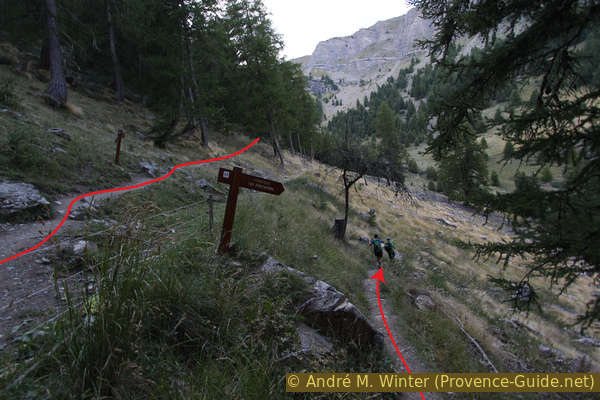
Through larch forests to the first chapel.
No reproduction is permitted without the written consent of the author. (id3587)
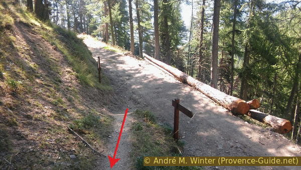
Ascent from Parking de la Forêt
After the embankment, the path becomes more comfortable!
vers = to
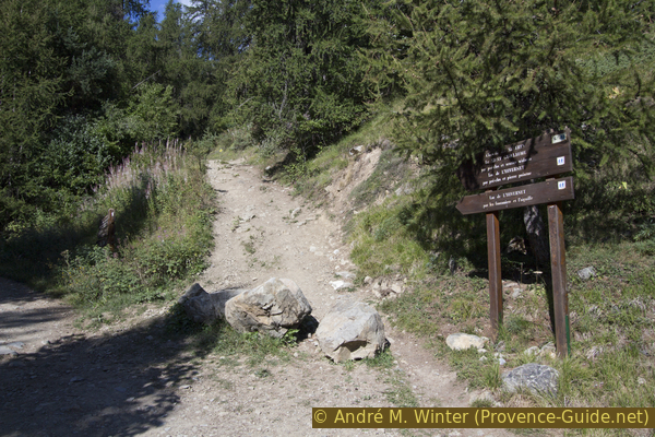
La Forêt car park is in a bend in the forest road. On the right are boards with information about the paths and the larch forest. There are many signposts around, basically we follow the signs to the Chapelle des Séyères.
So you take the turn to the left and then the first path on the right steeply up into the larch forest.
No reproduction is permitted without the written consent of the author. (id3588)
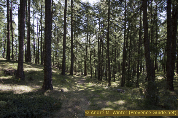
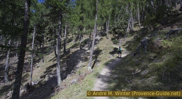
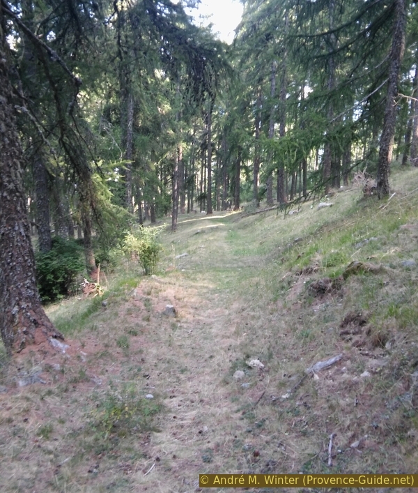
Larch forests at the foot of Mont Guillaume
The larches provide shade, but it remains airy and bright.
This trail is well marked and it quickly becomes less steep and more shady. At the first junction, we keep to the left, followed shortly after by a large clearing in the forest. Larches germinate in the light and cannot grow under tall trees, so areas of around 2000 m² are cleared to rejuvenate the forest.
At point 1762 on the IGN map, a forest road begins, on which we turn left, stay on it and head towards Sentier des Pépinières (not Pré Clos).
No reproduction is permitted without the written consent of the author. (id3589)
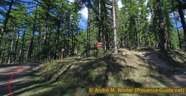
Forest road at point 1762 on the IGN map
forêt = forest
sentier = path
source = fountain
The forest road, which is flatter than the previous path, leads through the forest over two small hairpin bends. In the further course, the steeper path called Sentier des Pépinières crosses, which we immediately tackle upwards.
Forest workers were at work here in 2015.
No reproduction is permitted without the written consent of the author. (id3590)
Sentier des Pépinières
Now we stay longer on old and well-laid paths. This one was the old direct route from Embrun to the chapels that lie ahead. Two long hairpin bends take you to the last section of a forest road that leads directly to the Chapelle des Séyères. There was forestry work in the area around 2017 and new forest roads can now cross the path.
No reproduction is permitted without the written consent of the author. (id3591)
On the Sentier des Pépinières path
The larch forest thins out.
The Séyères chapel is located on a large alpine pasture, but the pines are moving up from below and you don't have the good view here as above. The chapel was rebuilt in 1879 by the Bishop of Gap. It is open but completely empty. The spring tapping was rehabilitated and covered in 2003, you can also shelter here if necessary.
In front of the chapel there is a large picnic area and a fireplace with wood.
No reproduction is permitted without the written consent of the author. (id3592)
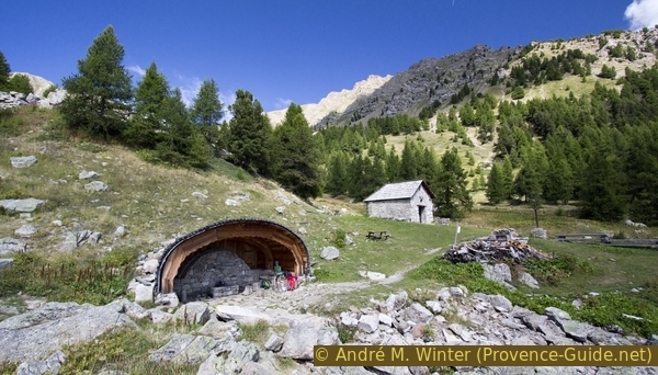
Spring tapping and Séyères chapel
You can shelter at the spring, but the chapel is usually open as well.
Section 2: Chapelle des Séyères - Mont Guillaume
➙ 3,1 km ... 1 h 20 min ➚ 475 m ➘ 0 m ↝ easy
100% easy trails, with marks
The clues
- Chapelle des Séyères, 2056 m
- Sentier Widman
- Mont Guillaume, 2531 m
To the second chapel and up the ridge.
We continue past the covered fountain and soon after a signpost leads us to the right onto Sentier Widman.
The following 500 meters in altitude are overcome in three large hairpin bends. The slope is quite constant and so you can climb at a good rhythm.
There are shortcuts, but it is better to stay on the marked trail. That is better for nature, but it also means we can manage our reserves better: we are not nearly halfway through the tour on Mont Guillaume.
No reproduction is permitted without the written consent of the author. (id3593)
On the way Sentier Widman
The path climbs in long hairpin bends, here we are on the first straight after the chapel of Séyères. In the background: Col de Trampa-Latz saddle.
crête = crest
sentier = path
This first cross also marks a parting of the ways. On the right de Sentier Widman continues, which makes another big hairpin bend, on the left an unmarked path that climbs more steeply over the valley also to Mont Guillaume. Here the official and marked Sentier Widman is described.
No reproduction is permitted without the written consent of the author. (id3594)
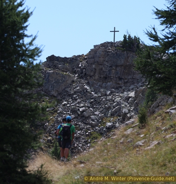
Cross under Mont Guillaume
This cross does not mark the summit, but it is visible from the valley.
After the second big hairpin bend, the Sentier Widman leads under rocks and crosses a small ditch. This point, which is not particularly difficult, is the only alpine feature on the entire route from the car park to Mont Guillaume. At other times of the year, however, this section of the trail should not be underestimated, it is on the shady side, covered with snow for a long time and therefore it may make more sense under such conditions to switch to the alternative on the valley side.
No reproduction is permitted without the written consent of the author. (id3595)
Short section in rocky area
Crête de l'Arpion in the background, which we will circle.
The chapel at Mont Guillaume has a nice shape. But you are also here for the view, you can see: the upper Durance valley, Embrun, the Queyras region, the large Lac de Serre-Ponçon reservoir and several mountains in the southern part of the Massif des Écrins. In summer, gliders and paragliders soar overhead.
No reproduction is permitted without the written consent of the author. (id2902)
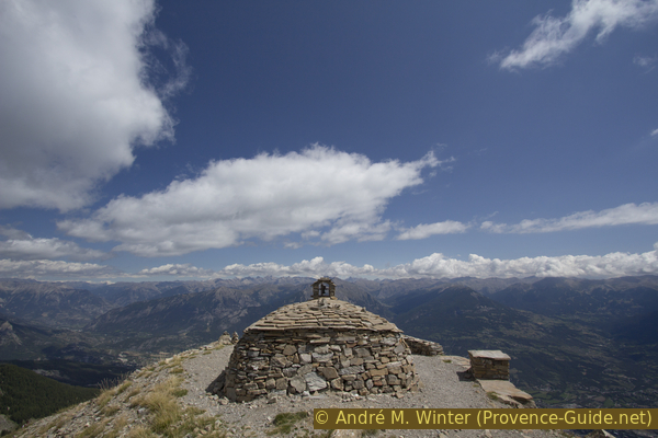
Chapel at Mont Guillaume and the Queyras Mountains in the background
Section 3: Mont Guillaume - Col de Trempa-Latz
➙ 1,3 km ... 40 min ➚ 85 m ➘ 80 m ↝ easy
100% easy trails, without marks
The clues
- Mont Guillaume, 2531 m, further along the ridge behind
- Pass below the point 2550
- Go over point 2623
- Col de Trempa-Latz saddle, 2537 m
Along the easy ridge behind the chapel.
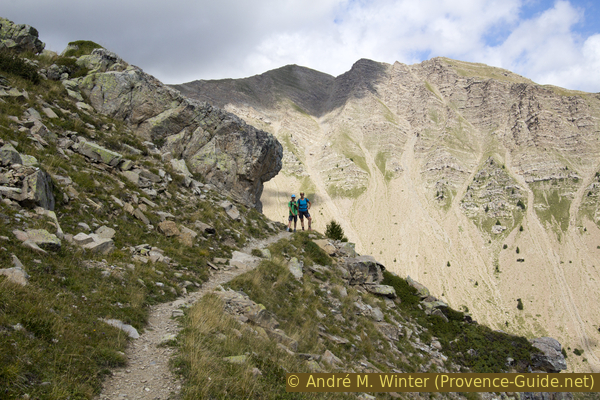
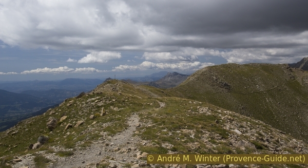
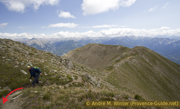
After extensively enjoying the unique distant view, most hikers return from the Saint Guillaume chapel along the ascent route. However, we continue our circular route on the wide ridge behind the chapel. An easy path leads over the ridge: after a saddle at 2531 m, you bypass an elevation of 2550 m on the right side in the slope. The other hills are taken directly along the ridge line, which is equally simple everywhere.
No reproduction is permitted without the written consent of the author. (id3596)
Easy ridge west and north of Mont Guillaume
View of the path behind the chapel to the Col de Trempa-Latz saddle.
From point 2623 there is a good view back to the Chapelle Saint Guillaume.
The ridge also allows for a wider view of the lake.
No reproduction is permitted without the written consent of the author. (id2903)
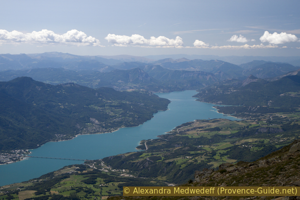
Lac de Serre-Ponçon reservoir
Since the ridge protrudes into the main valley, it is almost constantly exposed to strong winds. Therefore you need appropriate clothing, even if you were wearing shorts and a T-shirt on the ascent.
No reproduction is permitted without the written consent of the author. (id3598)
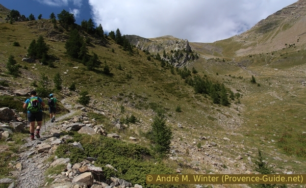
The ridge south of the Col de Trempa-Latz saddle
Looking back at the section of the ridge that has already been walked. At the end stands the chapel of Saint Guilaume.
Section 4: Col de Trempa-Latz - L'Arpion
➙ 0,6 km ... 20 min ➚ 135 m ➘ 0 m ↝ challenging
25% Trails with scramble passages, few cairns
75% cross country, without marks
The clues
- Col de Trempa-Latz saddle, 2537 m
- Rock ridge northeast of the saddle
- L'Arpion, 2671 m
This section is the most difficult one of the entire tour. The exact description of the ascent can be found below. If you change your mind here or if the weather changes, the alternative below is recommended.
raccourcis = shortcut
vers = nach
lac = lake
col = pass
crête = crest
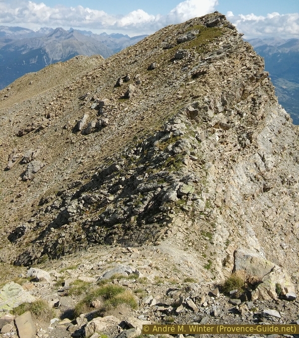
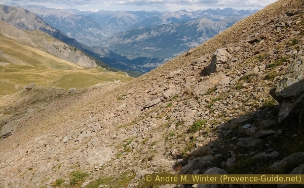
Climbing the rocks north of the Trempa-Latz saddle to L'Arpion is more difficult than the previous route, but definitely doable (difficulty level I for short).
Danger! There are no markings and no path can be identified. There are some cairns, but they are difficult to see from below. Do not climb the rocks when visibility is poor, it is essential to be able to see ridges, peaks and passes from afar in order to orient yourself. Some long steps have to be taken in the exposed area and the rock is quite brittle.
In detail: if you continue along the ridge, there is a visible path to the right (east) of the rocks in the ridge line. It is necessary to continue in this direction as far as possible without ever descending significantly until you reach a vertical and crumbling rock wall. Walk back a few steps from this cul-de-sac location and look for a passage to the other side of the ridge, there is also a cairn. On the west side you walk along a rather irregular step in the rock and have to go up two gullies. Loose rock makes it uncomfortable here. You act with the gullies as before: if you can't go any further, you climb towards the crest, but you don't cross it like before.
No reproduction is permitted without the written consent of the author. (id3599)
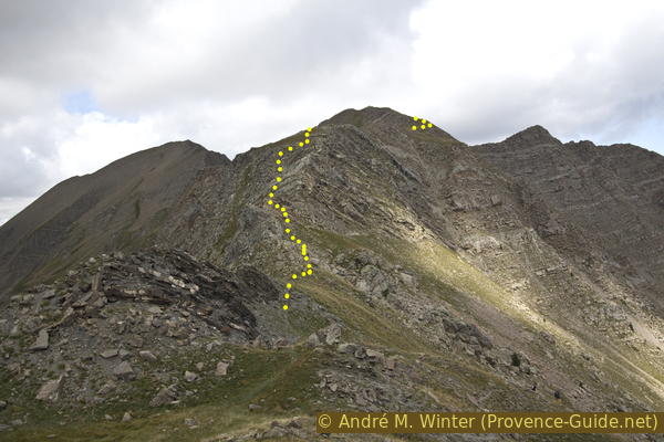
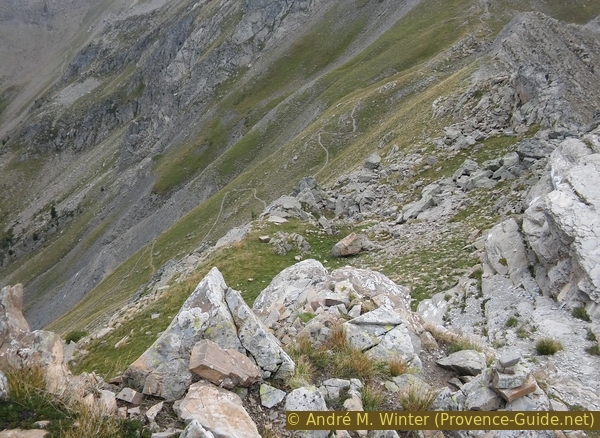
Ascent of the ridge north of the Col de Trempa-Latz saddle
The yellow dots indicate the approximate route.
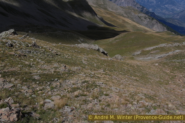
After the short rock passage you come to steep alpine meadows and flatter sections. We basically aim for the terrain in front of us, but you can switch back to the other side of the grassy ridge from about 2630 m above sea level. It is not necessary to climb to L'Arpion, 2671 m, for the loop, but it would be the highest peak of the day.
No reproduction is permitted without the written consent of the author. (id3601)
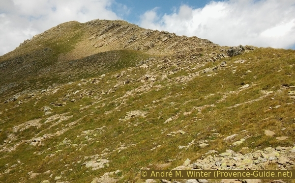
South below L'Arpion
Look ahead after the more difficult passage.
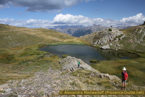
From L'Arpion or just below you can see the lake Lac de l'Hivernet. It's the dark area at the bottom of the Cirque de l'Hivernet. From here, of course, the view of the surrounding mountains also expands: in the north, Tête de Chante-Perdrix and Tête de l'Hivernet. To the east you can now see over Crête de l'Arpion. Further back, the Queyras mountain ranges appear quite small and a dark pyramid stands out on the horizon. It is Monte Viso, 52 km away in Italy.
No reproduction is permitted without the written consent of the author. (id3602)
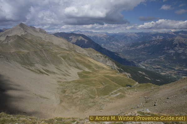
Cirque de l'Hivernet
On the left the eponymous mountain, Tête de l'Hivernet. Below the lake of the same name.
Section 5: L'Arpion - Lac de l'Hivernet
➙ 1,1 km ... 50 min ➚ 0 m ➘ 320 m ↝ average
100% hard-to-recognize trails, few cairns
The clues
- L'Arpion, 2671 m
- Descend steeply into the saddle in the east
- In the ditch downhill to the northeast
- Over the alpine pastures down to the lake
- Lac de l'Hivernet, 2352 m
The descent from L'Arpion is still unmarked and a path is rarely visible. Some cairns confirm that you are on the right path.
col = saddle
crête = crest
falaise = rock ridge
abrupte = hanging
barre = ridge
rocheuse = rocky
lac = lake
éboulis = scree
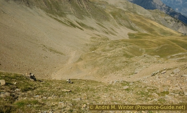
From L'Arpion, head east into the saddle, always slightly to the left of the crest. You can't see in the saddle from above, but you can get down without difficulty.
No reproduction is permitted without the written consent of the author. (id3603)
The saddle between L'Arpion and the ridge of Crête de l'Arpion
First down towards the saddle.
Just before the saddle, the path turns left and we follow this barely visible trail. For the time being we remain in the finer scree cone to the left of the ditch.
No reproduction is permitted without the written consent of the author. (id3604)
Descent left just before the saddle east of L'Arpion
Descent into the cirque.
So it goes further down until you stand above a vertical rock wall. Larger cairns mark this spot.
No reproduction is permitted without the written consent of the author. (id3605)
Behind the cairns, it goes steeply downhill
Here you should keep to the right and take the path across the coarser scree cone. Shortly thereafter descend diagonally again.
No reproduction is permitted without the written consent of the author. (id3606)
Crossing in the coarser scree field
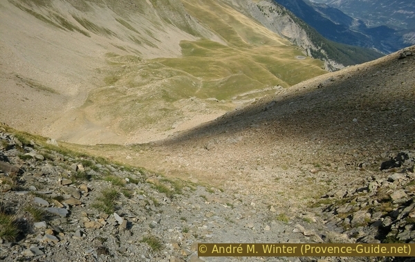
From above you could see straight rocky outcrops pointing in the direction of Lac de l'Hivernet. These bars are surrounded by alpine meadows. One should aim for the top of the first one, the cairns on our path point there. As soon as you leave the debris cone, the visible path is lost. Attention: we are on an alpine pasture with many sheep and their paths lead everywhere, but not necessarily to the lake.
There are still 130 vertical meters down to the lake, which means that there are also transverse rock walls that you should avoid. The easiest and most direct way we found is this one:
First go behind (on the north side) the first rock bar and along it in the direction of the lake. At the end of the bar and before the next ledge, switch to the front (south) and continue downhill to the east until it gets really steep. You then change into the rock ledge, which is now steep but passable.
No reproduction is permitted without the written consent of the author. (id3607)
End of the scree field and beginning of the pastures
You aim for the alpine meadow to the right of the center of the picture and turn right behind the gray rocky outcrop.
At the end you are on a kind of rock ramp that leads you directly to the lake shore. Turn left (north) past the last rock.
Go counter-clockwise around the lake. Opposite there is another rock that you just climb up from the path. From there you have a good view of the lake and the descent path.
No reproduction is permitted without the written consent of the author. (id3608)
In the last rock ramp above the Lac de l'Hivernet
Section 6: Lac de l'Hivernet - Parking de la Forêt
➙ 4,3 km ... 1 h 30 min ➚ 0 m ➘ 770 m ↝ easy
60% easy trails, with marks
35% forest roads, few marks
10% hard-to-recognize trails, without marks
The clues
- Lac de l'Hivernet, 2352 m
- L'Aiguille, 1875 m
- Les Fontainiers, 1709 m
- Parking de la Forêt, 1587 m
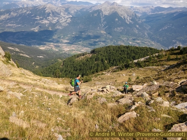
Steep descent into the forest and back to the starting point.
A marked path begins again at the rock in the south-east of the lake. It leads quite abruptly over an edge in steep and narrow bends into the valley. You slowly get back into the forest.
No reproduction is permitted without the written consent of the author. (id3609)
Descent under the Lac de l'Hivernet
In the larch forest is a fork in the path. Both paths lead down to the La Forêt car park. Straight ahead is Pré Clos. We take the second path via L'Aiguille, which brings us downhill faster and more regularly. In the forest, the path makes an abrupt turn to the right and then left again, but this is well marked.
L'Aiguille is an alpine pasture with a few huts. Here begins a forest road that takes us to the Les Fontainiers (or Les Fontaniers) forest huts, here the alternative path from Pré Clos also comes down.
No reproduction is permitted without the written consent of the author. (id3610)
Turnoff to the Alpe l'Aiguille
Attention, below Les Fontainiers, there is no signpost. When you get to these houses in the forest, you follow the forest road, which is wider here, into a hairpin bend. Less than 20 meters later, a signpost shows the route to the car park, but only via the forest road. There is a nicer way: just opposite the signpost, go into the forest (possibly over the electric fence) and down at a right angle to the road. You come across an old path that meets our ascent trail. Here in a few minutes back to the starting point.
No reproduction is permitted without the written consent of the author. (id3611)
Old path under the Les Fontaniers mountain pasture
Appendix: Col de Trempa-Latz - Chapelle des Séyères
➙ 0,7 km ... 15 min ➚ 150 m ➘ 0 m ↝ average
100% hard-to-recognize trails, without marks
The clues
- Col de Trempa-Latz saddle, 2537 m
- Chapelle des Séyères, 2056 m
This alternative makes it possible to shorten the route and avoid the difficult passage north of the Col de Trempa-Latz.
A good but unmarked path leads down from the saddle on the right in steep hairpin bends through alpine meadows. In this area, the route always stays to the left (north) of the ditch. At about 2430 m above sea level there is a fork in the path: one path leads quite steeply more directly downhill, the other takes you further north in wide hairpin bends (this route can be found in the KML and GPX files). At about 2235 m above sea level, the slope flattens out and the paths reunite before crossing a torrent. Don't stay north of the water course any longer here, this path gets lost in the slope. After crossing the creek, there are two more options: keep to the far right and switch to the Sentier Widman in the first big hairpin bend (this is how it is noted in the KML and GPX files) or stay to the right of the creek.
To return to the starting point, take section 1 in reverse. After the chapel, you can also stay on the forest road and descend less steeply, but longer, via Alpe Pré Clos.
Sources and additional information
It is better to use good topographical hiking maps: This tour is on two different IGN maps "Embrun, Les Orres, Lac de Serre-Ponçon", scale 1:25000, 3438ET (up to the Col de Trempa-Latz saddle) and "Orcières -Merlette, Sirac, Mourre-Froid, Parc National des Écrins", scale 1:25000, 3437ET (northern part with the Lac de l'Hivernet).
If you don't want to bother with a paper map, you can also use mapping apps on your cell phone. On the one hand, it is the Cartes IGN app from the official map service. However, it requires access to the data network and this is sometimes difficult in canyons or remote locations.
Alternatively, you can use apps that store data directly on the device. They're generally not free, but they don't cost much. We mainly use OSMAnd, here it is possible to add contour lines, relief shading, markings and others. To store this data on your phone you need a lot of space.
Of course, one needs access to satellites for the GPS signal with any app. In some canyons this is not the case. Therefore, do not rely on the position shown, but read the map on your phone as you would read it on paper. Most apps are available for Android and iPhone. The applications usually allow us to record the route travelled and also view the GPS files offered for each of our hikes.
This page has been seen 2307 times since 20 March 2024.
No reproduction is permitted without the written consent of the author. (id3600)
Way down from the Col de Trempa-Latz