Canal du Verdon and Sainte-Maxime chapel
On the renovated path through the Basses Gorges du Verdon and across the limestone plateau
hike
easy
3 h 30 min
near
yes
shelter
mountain
Introduction
The path accompanying the lower Verdon canal was partially restored in 2014. Originally, it accompanied the entire length of the Verdon Canal. This canal, initially realized between Quinson and Aix-en-Provence, was built between 1863 and 1875 by forced labourers. In the 1960s, the canal was closed, the Gréoux reservoir caused the water to rise and flooded part of the path accompanying the canal. New walkways have been added in these areas, making it possible to safely walk three kilometres through the canyon.
At the end of the developed path we pass the dark gorge of Sainte Maxime and climb up to the chapel on the ridge. The way back takes us across the plateau south of the gorge. The descent via l'Escourche back to the starting point of the tour is steep.
The facts
8,9 km total distance
3 h 30 min walk time
330 m total elevation
orientation easy, but some junctions are not marked
mark 100% of the total distance
45% easy trails
30% dirt roads
10% hard-surfaced paths
10% stairs
<5% hard-surfaced quiet side streets
<5% tunnels
dangers heat in summer, tunnel without light
children if they have the appropriate walking experience and with supervision
useful picnic stuff, swimming gear
required hiking boots, hiking equipment, water, flash-light
GPS coordinates (WGS84) of start and end point 43.693991,6.034882
downloads ![]()
![]()
No reproduction is permitted without the written consent of the author. (id3659)
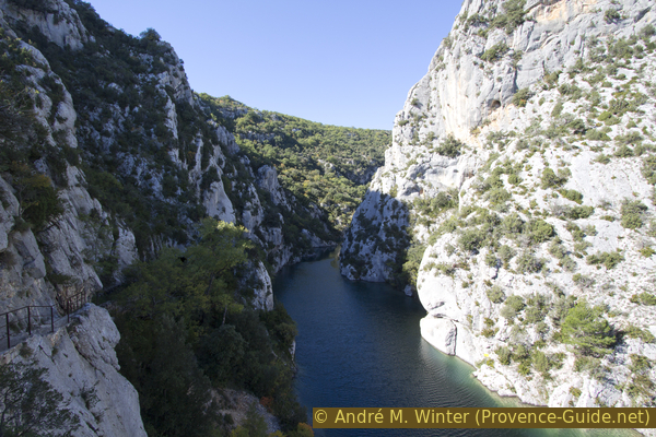
Basses Gorges du Verdon at the beginning of the tour
Public transport
The usual access is via Gréoux or Riez, the connections change often and are far from perfect.
Information at Zou! (only french): Look for the stop timetable for the commune of Quinson. Some of these lines are school transport or on-call services (TAD), you should also get detailed information at the tourist office and complain there too: the public transport offer around the Verdon is very bad.
To get to the starting point: follow the road to the bridge over the Verdon, cross it and stay on the right: the path begins a few meters further with stairs.
Access by car
The tour starts just south of the bridge over the Verdon in Quinson. Coming from Nice, leave the motorway at Le Muy and continue past Draguignan, Salernes, Sillans-la-Cascade and Montmeyan. From Aix-en-Provence, leave the motorway at St. Maximin and approach the Verdon via Brue-Auriac, Varages and Montmeyan. From the north you drive via Riez to Quinson.
Useful parking spaces
There are approximately 6 car parks north of the bridge over the Verdon. There are more places on the access road to the beaches south of the Verdon: coming from Quinson, after the bridge, take the first road on the left, arrows indicate the possibility of renting kayaks and electric boats.
Hints
The first part of the tour leads over footbridges, stairs and partly on the retaining wall on the canal or inside the canal itself. Without gaining or losing height, you have to climb and descend a multitude of stairs: the accompanying path goes around mostly all the tunnels of the old Verdon canal.
Although it is quite shady at the bottom of the gorge, it is still possible to do this tour in winter when the weather is nice: the sun enters the gorge, which changes direction several times. In winter, however, certain areas can be slippery and the slope on the plateau can be muddy.
After the keeper's cottage, the path leads through a tunnel. This is the only tunnel you have to go through (the others are forbidden to enter). There is no alternative to this more than 100 m long tunnel. It is not lit but is straight so you can see the other end. The ground is not very flat and there is often water up to 10 cm deep in the tunnel. Flash-lights or headlamps as well as high and waterproof shoes are of good service here.
Around the chapel and on the plateau are semi-wild goats with big horns. These are not dangerous, but curious. They approach silently and you may come face to face with them without warning. On the other hand, you can clearly smell them.
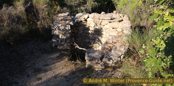
The walk back across the plateau is long and monotonous, but towards the end there are some bories (dry stone houses) and stone fountains to be found along the way.
The whole region is a zone with a high risk of forest fires. In summer, but also in other seasons when it is very dry or by strong winds, access to the forest areas can be regulated. As a result, the roads may be closed to traffic and/or the trails prohibited to hikers. Current information: Access map to the forests of Alpes de Haute Provence (also english). The map shows the colours green, yellow, orange and red which correspond to levels of danger. The affected area is: Moyen Verdon.
The sections
- Quinson bridge - Attendant's hut: the upgraded part
- Attendant's hut - Chapel Sainte Maxime: a tunnel, a dark valley and the ascent to the ridge
- Chapel Sainte Maxime - L'Escourche: the ridge and the limestone plateau
- L'Escourche - Quinson bridge: steep descent and back over a canal bridge
Bistros and restaurants are only found in Quinson and these are almost exclusively open in the high season. In summer there are also buffets on the beaches by the lake.
The keeper's cottage at the bottom of the gorge and the chapel on the ridge can be used as a shelter. These are simple buildings and completely empty.
No reproduction is permitted without the written consent of the author. (id3407)
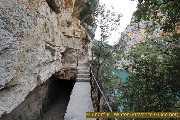
The old canal on the Verdon and the accompanying path
Section 1: Pont de Quinson - Cabane du Gardien
➙ 3 km ... 1 h ➚ 100 m ➘ 100 m ↝ easy
30% stairs, with marks
30% hard-surfaced paths, with marks
40% easy trails, with marks
The clues
- Bridge at Quinson, 365 m
- Stairs to avoid the bottleneck
- Way of the canal guardian
- Warden's cabin, 360 m
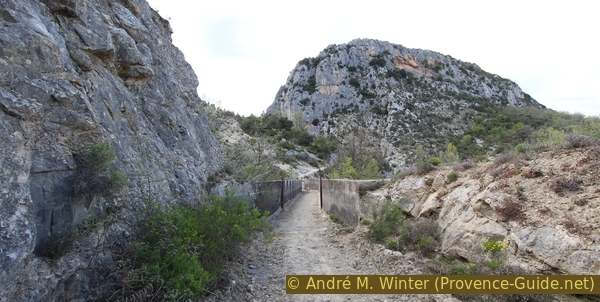
This whole section of the tour is done on the facilities of the old canal. Since these are brick facilities in the gorge wall, there is only one and also steep way to get to the water. This point is opposite the only path that leads up to the plateau.
lac = lake
sentier = trail
garde-canal = canal guardian
pont = bridge
South of the bridge you don't have to go much further before you stumble over stairs that lead up to the rock shoulder with large steps (signpost below). This first ascent makes it possible to overcome a bottleneck in the gorge. Above there are signs explaining the natural environment, here you will also find a map describing the tour.
No reproduction is permitted without the written consent of the author. (id3658)
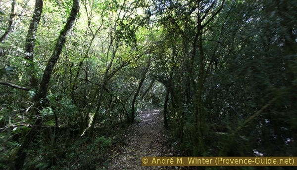
Beginning of the path on the canal along the Verdon near Quinson
From up there you descend again to about the level of the canal, which now accompanies you the entire way on the left side. All ascents and descents towards the keeper's cabin lead via stairs that have either been hewn into the rock, have been specially created or lead over wooden walkways. Long flat sections follow the canal either on the retaining wall or on the embankment next to the wall.
Several parts of the trail are carved directly into the rock. It is therefore a type of very easy via ferrata. But of course there are also long parts on the embankment under the canal.
No reproduction is permitted without the written consent of the author. (id3408)
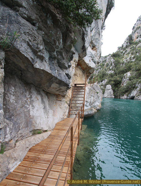
The path accompanies the canal in the Basses Gorges du Verdon
A railing accompanies the path where it directly borders the river or canal, but not everything is insured. Large parts of the path are directly on the retaining wall, where a hole more than 2 m deep gapes right next to the canal. Here you have to be very careful, especially with children!
Attention: it is forbidden to enter the tunnels, initially the path remains outside the canal anyway. On the one hand, the tunnels carved in stone are no longer maintained, but above all there are bats inside that rest during the day. You only have to go through the last tunnel after the keeper's house.
No reproduction is permitted without the written consent of the author. (id3660)
On the accompanying path of the canal
l'eau = water
sentier = trail
garde-canal = canal guardian
After about half an hour, while the trail runs along the embankment next to the canal for a long stretch, there comes a junction marked by a bridge over the canal and a signpost. If you take the fork here and go uphill, you can shorten the itinerary and go directly to the La Draille des Vaches crossroads on the limestone plateau. You can return to the start of the tour from here in around 45 minutes. However, the ascent on the long stairs is strenuous. If you don't have time, it's better to turn around and hike back the same way.
No reproduction is permitted without the written consent of the author. (id3661)
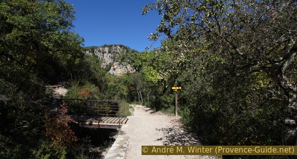
Beginning of the path that goes up to the Draille des Vaches
A descent to the water is possible a little before on the right.
However, the bridge over the canal and the signpost also mark a path that leads down to the water. You have to go back a little to find the passage in the bushes. The surrounding area has nothing special, but it's the only easy and safe way to go down and take a dip in the refreshing water. You should take advantage of this opportunity in summer!
No reproduction is permitted without the written consent of the author. (id3662)
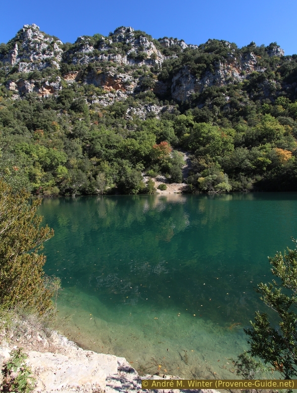
Possible descent to the Verdon
About 10 minutes before the keeper's cabin, the path changes to the bottom of the canal. You now have the rock wall on one side and the more than two meter high wall on the other side. This section is a bit boring as the field of view is severely limited. However, openings have been made in the retaining wall, one even with a real natural platform and a beautiful view over the gorge.
No reproduction is permitted without the written consent of the author. (id3663)
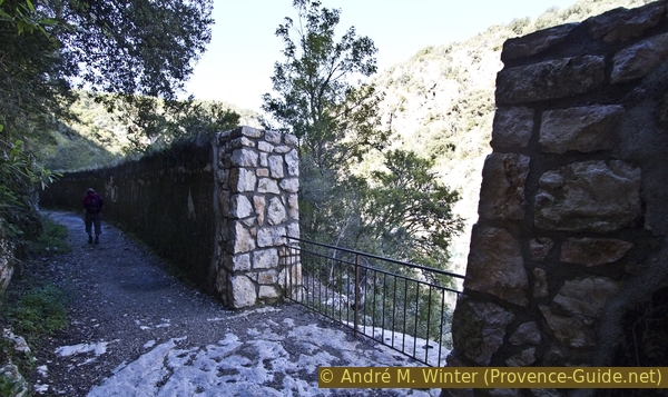
Opening in the retaining wall
A little further on is the said keeper's hut, a last opening allows you to pass the embankment to the outside. The cabin is open and can be used as a shelter, but there is no furniture inside, not even a bench. On the other hand, there are information boards that explain the construction and functioning of the canal with old photos and engineering plans.
No reproduction is permitted without the written consent of the author. (id3664)
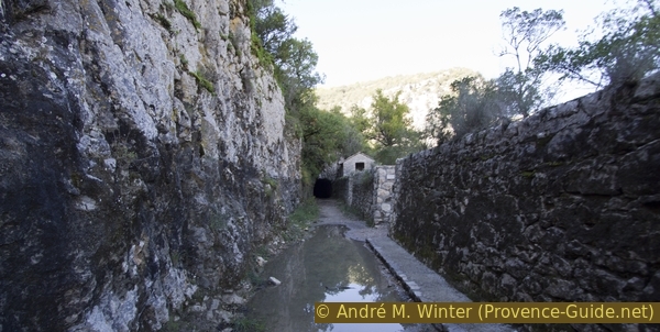
Path in the Verdon canal, last tunnel and keeper's cabin
Section 2: Cabane du Gardien - Chapelle Ste. Maxime
➙ 2 km ... 1 h ➚ 140 m ➘ 0 m ↝ easy
5% tunnels, without marks
95% easy trails, with marks
The clues
- Warden's cabin, 360 m
- Tunnel
- Ravin de Sainte Maxime to La Charbonnière, 420 m
- Carrefour de Sainte Maxime, 470 m
- Sainte Maxime chapel, 500 m
This section starts with the darkest part of the tour: first you have to go through a tunnel, then you climb through the Sainte Maxime ravine. But in the end you reach the top of the ridge.
en ruine = ruined
pont-canal = canal bridge
ravin = ravine
chemin dans = trail in
cabane = hut
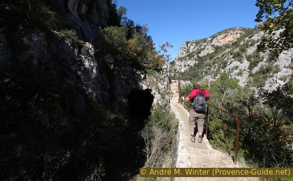
After the keeper's cabin, you have to return to the canal and go through the tunnel. This cannot be bypassed on the path on the right side of the cottage! This path descends steeply into a cul-de-sac and ends abruptly at a cliff.
No reproduction is permitted without the written consent of the author. (id3665)
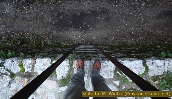
Ladder leading down into the Verdon canal
You can also easily bypass the ladder.
The tunnel is completely straight, so you can see the other end as soon as you enter it. But there is no lighting. A flash-light or headlamp for each tour participant is mandatory as the ground in the tunnel is very uneven. There can be many puddles in the tunnel that are up to 10 cm deep. These puddles can be up to several meters long and stretch across the entire width of the tunnel, so it makes sense to wear sturdy shoes. You should also not try to go through the tunnel barefoot, as there are many sharp stones, it is quite cool and the length of the tunnel is more than 100 m.
No reproduction is permitted without the written consent of the author. (id3666)
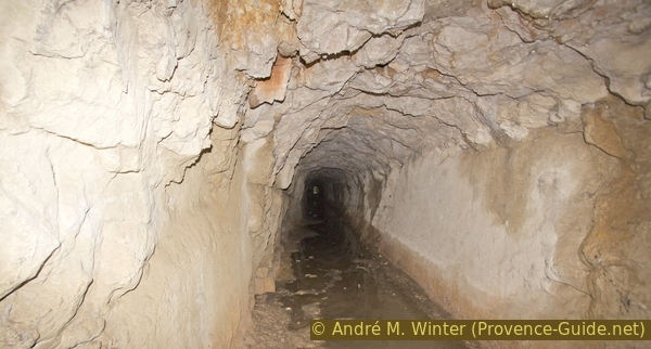
This tunnel on the way by the canal has to be crossed
At the end of the tunnel you leave the canal to the left via a set of stairs. You can go a few steps further in the canal (which is a canal bridge here), but the rocks that have fallen into the canal and the brambles quickly block the way. Another tunnel follows shortly after. Don't venture further! It is easily recognizable by the fallen rocks and the entrance to the unmanaged tunnel: unlike natural caves, these man-made unmanaged caves are subject to severe deterioration over time. The stone blocks can fall off the rock face, just as the tunnel ceiling or the retaining wall at any moment. The old accompanying path is completely missing from here.
After the tunnel and exit from the canal, you can descend to the right under the aqueduct bridge into a wide bay and the water. However, it is very shady here and the current washes a lot of branches and leaves into the bay. It is therefore not an ideal bathing spot.
No reproduction is permitted without the written consent of the author. (id3667)
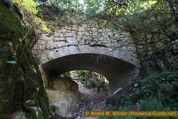
Aqueduct bridge in the Sainte Maxime gorge
Turn left after the canal to continue the tour. We are now staying at the bottom of the dark valley of Sainte Maxime, which is a lateral gorge to the left of the Verdon. Dwarf oaks grow in the gorge, which in turn are covered with lichen, indicating that it has been very dark and humid here for long periods of time. But the forest also prevents you from seeing the gorge itself.
The path on the bottom is easy, following the meanders of the ravine. It meanders along the river bed and you are forced to lose your orientation. But it is enough to follow the clear path, always slightly uphill.
About ten minutes after the canal, you come across another path that climbs steeply to the left as far as the Sainte Maxime chapel. This old trail has long been closed due to falling rocks, don't cut off here, it's really dangerous.
No reproduction is permitted without the written consent of the author. (id3668)
The path at the bottom of the Sainte-Maxime gorge
Chap. = Chapel
As you follow the bottom of the gorge, you gradually climb up. The gorge widens and the forest gets higher. At the same time, the path turns into a passable forest road. Some dirt roads branch off to the left. Ignore them and continue gently climbing at the bottom of the gorge. About 20 minutes after the canal, a signpost marks the place called La Charbonnière (the charcoal burner woman). Here the marked path of the variant of the GR99 leads up to the left.
No reproduction is permitted without the written consent of the author. (id3669)
Ascent from the Sainte Maxime gorge to the Carrefour Sainte Maxime
The path is a kind of ramp and steeper than before in the valley. After a few minutes we reach the ridge south of the Basses Gorges du Verdon, at the same time we reach open terrain again and mostly return to the sunshine!
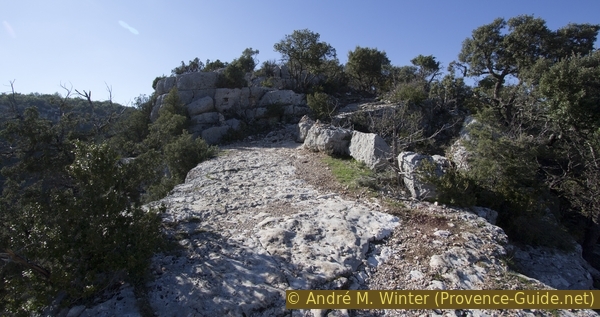
At the top by the Carrefour de Sainte Maxime, we turn left. We quickly pass a saddle before a final climb takes us up a rocky ramp and we arrive at the Sainte Maxime plateau. There is the chapel, an old watchtower and plenty of space for a well-deserved picnic.
No reproduction is permitted without the written consent of the author. (id3670)
Turn off on the ridge east of the Ste. Maxime
The chapel on the edge of the terrain south of the Basses Gorges du Verdon is more recent. Built in 1854, it replaced a Romanesque chapel, the remains of which can be found below. A pilgrimage to the chapel takes place every year on May 16th.
Saint Maxime was born in the 7th century and died in the 8th century. Daughter of the Count of Grasse, squire of Antibes, she became a nun in the convent for women in Arluc, founded by Saint Cassien. She then became superior of the convent of Callian in the Var.
No reproduction is permitted without the written consent of the author. (id3409)
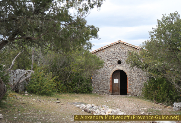
Stainte Maxime du Verdon chapel
Section 3: Chapelle Ste. Maxime - L'Escourche
➙ 2,4 km ... 1 h ➚ 70 m ➘ 50 m ↝ easy
5% easy trails, with marks
95% dirt roads, few marks
The clues
- Chapelle Sainte Maxime, 500 m
- Carrefour Sainte Maxime, 470 m
- Draille des Vaches, 540 m
- Plateau de Mala-Soque (Male-Sauque), 545 m
- L'Escourche, 525 m
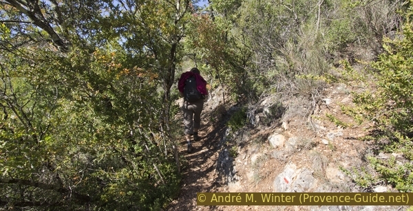
First back along the ridge, then cross the limestone plateau from north-west to south-east.
The way back runs to the Carrefour Sainte Maxime first on the same ridge that you came. Then continue straight ahead in the same direction, passing under a hill again to the north. At the end of the same we reach the limestone plateau and quite quickly a forest road. This spot is marked on the IGN map with a wayside cross, but it's ruined with only a few bricks on the ground showing it. We pass it on the forest road and turn right, where we ascend slightly.
No reproduction is permitted without the written consent of the author. (id3671)
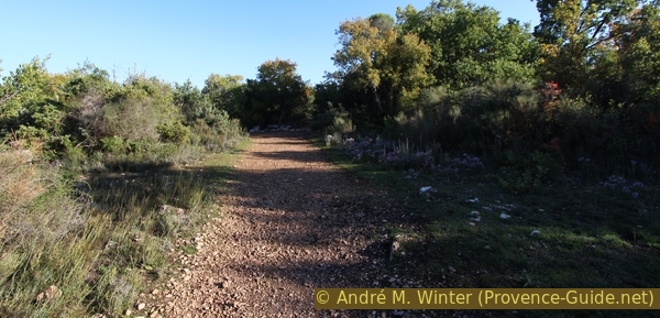
Forest road on the Draille des Vaches plateau
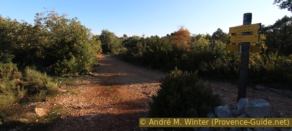
About 200 m further we come to a fork with ruins covered by vegetation. Here we turn left towards the east. After the hill, the forest road becomes very flat. Further signposts await us at the Draille des Vaches (cattle trift) and on the Male-Sauque plateau. However, we continue our way straight ahead, we stay at the same height, around 540 m.
No reproduction is permitted without the written consent of the author. (id3672)
Forest road on the Male-Sauque plateau
We continue walking without much change in the environment around us, but little by little the view of the Quinson plain opens up. We are also approaching the Escourche escarpment, where we descend the meters that we previously climbed in the Sainte Maxime gorge. A little before the descent you can see old wells on both sides of the road. Beware, these are deep and completely unsecured!
No reproduction is permitted without the written consent of the author. (id3673)
Old well on the Male-Sauque plateau
Section 4: L'Escourche - Pont de Quinson
➙ 1,5 km ... 30 min ➚ 20 m ➘ 180 m ↝ average
45% easy trails, faulty marks
25% dirt roads, faulty marks
5% hard-surfaced quiet side streets, with marks
10% easy trails, few marks
5% hard-surfaced paths, few marks
5% stairs, with marks
The clues
- L'Escourche, 525 m
- La Blaque, 375 m
- Canal bridge
- Quinson bridge, 365 m
The last section runs first in a steep descent, then we return to our starting point.
No reproduction is permitted without the written consent of the author. (id3674)
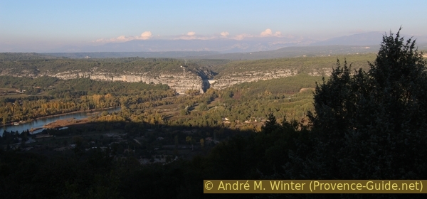
The Quinson dam was commissioned in 1974
The descent is rocky and really breakneck. Whether you follow the poorly maintained forest road or the path that cuts off some bends in the road doesn't change anything. But it does have a good view of Quinson and the Quinson dam a little upstream.
Arriving on the D13 road, stay on the same side and just after the bridge, take a path parallel to the road. This path takes us to a last section of the Verdon canal and to a canal bridge that is more recent but not in use.
No reproduction is permitted without the written consent of the author. (id3410)
Canal bridge on the edge of the Quinson plain
At the end of the water bridge, stairs lead to the ascent from the start of our tour. We now descend to the starting point.
Sources and additional information
It is better to use a good topographical hiking map: this tour is on the IGN "Gréoux-les-Bains" map, scale 1:25000, 3343OT.
If you don't want to bother with a paper map, you can also use mapping apps on your cell phone. On the one hand, it is the Cartes IGN app from the official map service. However, it requires access to the data network and this is sometimes difficult in canyons or remote locations.
Alternatively, you can use apps that store data directly on the device. They're generally not free, but they don't cost much. We mainly use OSMAnd, here it is possible to add contour lines, relief shading, markings and others. To store this data on your phone you need a lot of space.
Of course, one needs access to satellites for the GPS signal with any app. In some canyons this is not the case. Therefore, do not rely on the position shown, but read the map on your phone as you would read it on paper. Most apps are available for Android and iPhone. The applications usually allow us to record the route travelled and also view the GPS files offered for each of our hikes.
This page has been seen 4132 times since 20 March 2024.
No reproduction is permitted without the written consent of the author. (id3675)
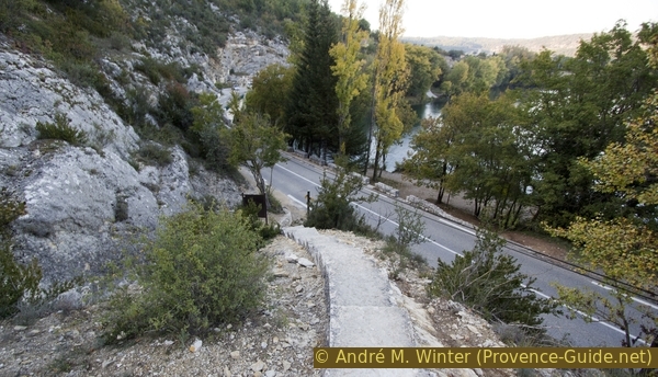
Stair between the canal path and the road