Saint-Pierre Collegiate church in Six-Fours
Historical and cultural site
15 min
view point
Site history
The village of Six-Fours, known as Six-Forts during the Middle-Ages, was the property of the abbots of St. Victor of Marseilles during the 11th century.
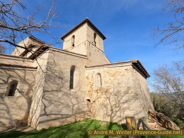
In the 13th century, the Six-Fours priory was one of the most important in the region. Since then, a bell tower has spanned the east wall and the Romanesque nave. It has a square shape
Set at the top of a 210-metre hill, Six-Forts was protected by two, then three solid walls and served as a refuge for neighbouring populations during the numerous invasions of Barbarians from the north and Saracens from the sea. St. Pierre collegiate church is the sole remnant of the old fortified village. Thanks to the discovery of a baptistery and ruins of an extremely ancient chapel its origins are now known to date back to the 4th and 5th centuries of our era (it was undoubtedly built on the site of a Greek acropolis, then a Roman temple).
No reproduction is permitted without the written consent of the author. (id6351)
Collégiale St. Pierre church
An east-west orientated Romanesque church built in the 11th century contained the former buildings. During the construction of the Gothic church, the priory and part of the left aisle as well as the Romanesque north wall were destroyed.
The north-south orientated Gothic church with six chapels, added in 1608 in order to increase the church's capacity, was built on the ancient priory. It was consecrated in 1634 and made a Collegiate church 20 years later. During the 18th century, the village's inhabitants descended gradually onto the plain below and the village's administrative centre was transferred 1790. The military fort was built in 1875 on the site of the destroyed former village.
No reproduction is permitted without the written consent of the author. (id6350)
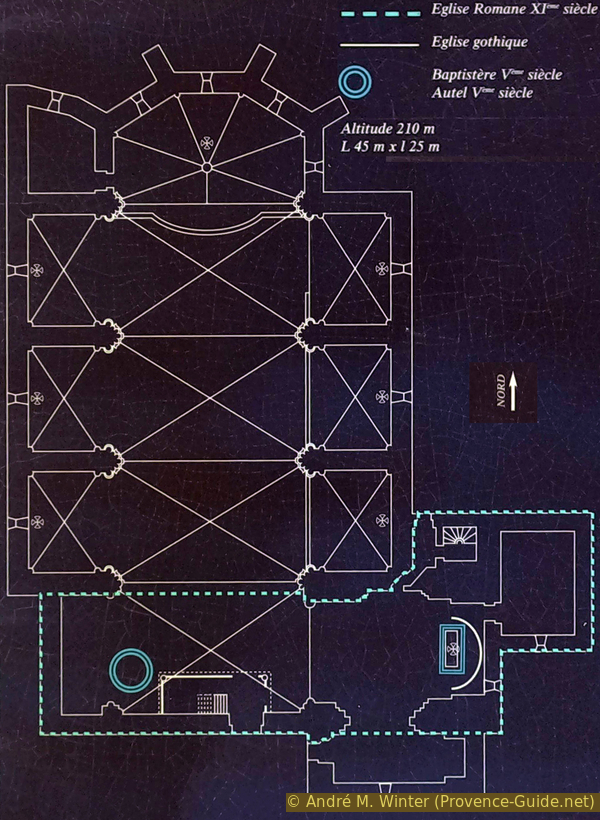
Map of the Church of Saint-Pierre-aux-Liens in Six-Fours
The Romanesque part, oriented east-west, is 25 meters long and 16 meters wide between the aisles. The height is almost 10 meters. It was built of grey-blue limestone from Évenos.
Its large barrel vault gives the whole an impression of calm and perfectly balanced power.
No reproduction is permitted without the written consent of the author. (id6353)
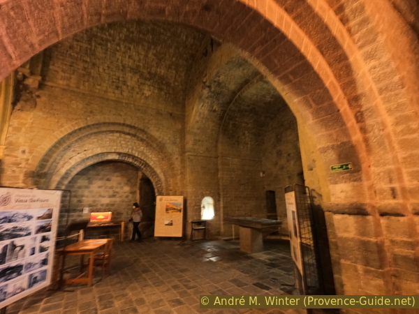
Romanesque vaults of the Collegiate Church of St. Pierre
The church bears the Romanesque style in its architecture: dark, massive, in the shape of a Latin cross with two slightly trapezoidal chapels with narrow and curved stained glass windows.
No reproduction is permitted without the written consent of the author. (id6352)
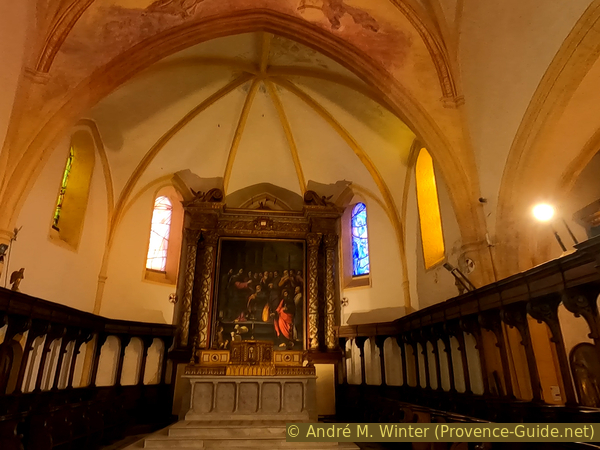
St. Pierre collegiate choir
Access by public transport
The Fort of Six-Fours and the Church are situated on a green hill between Six-Fours-les-Plages and La Seyne. The most useful bus line is number 70 of Réseau Mistral (only french). It departs from Toulon train station and also stops at La Seyne Six Fours train station. From here head south of the station and turn left, cross the tracks and continue straight until you get to La Gare bus stop.
Get off at the Pont du Brusc stop, go ahead to the roundabout and turn right here up the Chemin du Grand Chrestian.
The other terminus of line 70 is Plage de Bonne Grâce between Six-Fours and Sanary. From here, get off at the Gabois stop, go ahead to the roundabout and turn left up Chemin du Grand Chrestian.
The Chemin du Grand Chrestian climbs in a straight line. When it turns left to go down, continue straight on a set of stairs between two driveways. At the next intersection, turn right onto Chemin de la Garrigue. We reach one of the hairpin bends of the Montée du Fort where we continue to climb. At the next crossroads straight ahead to the church.
This access has a height difference of 170 meters and the ascent takes about 30 minutes.
Access by car
La Seyne and Six-Fours are confusingly constructed. The main axis of the D559 runs between the beaches of Six-Fours to the west and the town of La Seyne to the east. Several roundabouts line this axis. The Montée du Fort street is signposted for Collégiale St. Pierre and Fort de Six-Fours. It goes uphill to the military fortress and the church.
The car park lays under the military fort
No reproduction is permitted without the written consent of the author. (id6349)
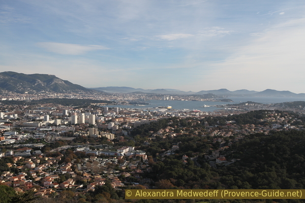
View of the Rade de Toulon bay from the Collégiale St. Pierre
The Fort of Six-Fours
At the end of the 19th century, the Navy acquired the old fortified village of Six-Fours, completely leveling it and building the fort from 1875. Today it is a communications center for the French Navy and serves as the command center for the nuclear-armed Air Force.
Access and photos are prohibited.
No reproduction is permitted without the written consent of the author. (id6355)
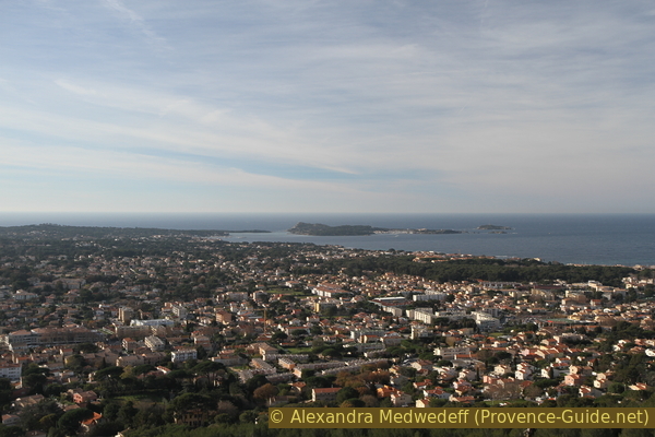
Six-Fours and Îles des Embiez islands
View from the hexagonal tower
Passing the fortress and descending to the first bend in the road, one comes to a ruined tower. From here you can also see well to the south and south-west.
For those who came up on foot: descend along the road to find the ascent path in the third hairpin bend.
No reproduction is permitted without the written consent of the author. (id6356)
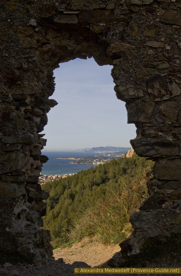
Hole in the ruined hexagonal tower under the Fort of Six-Fours
No reproduction is permitted without the written consent of the author. (id6354)
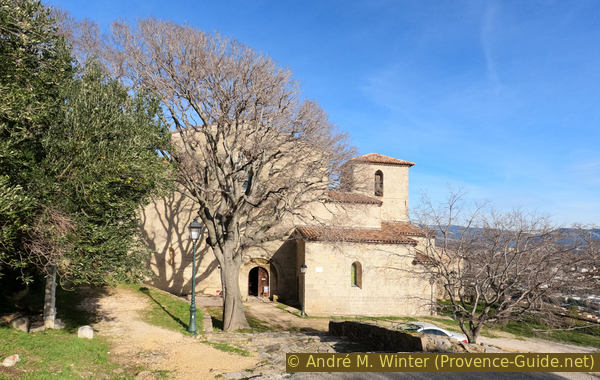
Saint-Pierre-aux-Liens church in Six-Fours-les-Plages